This item has been sold, but you can get on the Waitlist to be notified if another example becomes available.
1959 Brewer Pictorial Map of Colorado
CentennialScenicMap-brewer-1959$125.00

Title
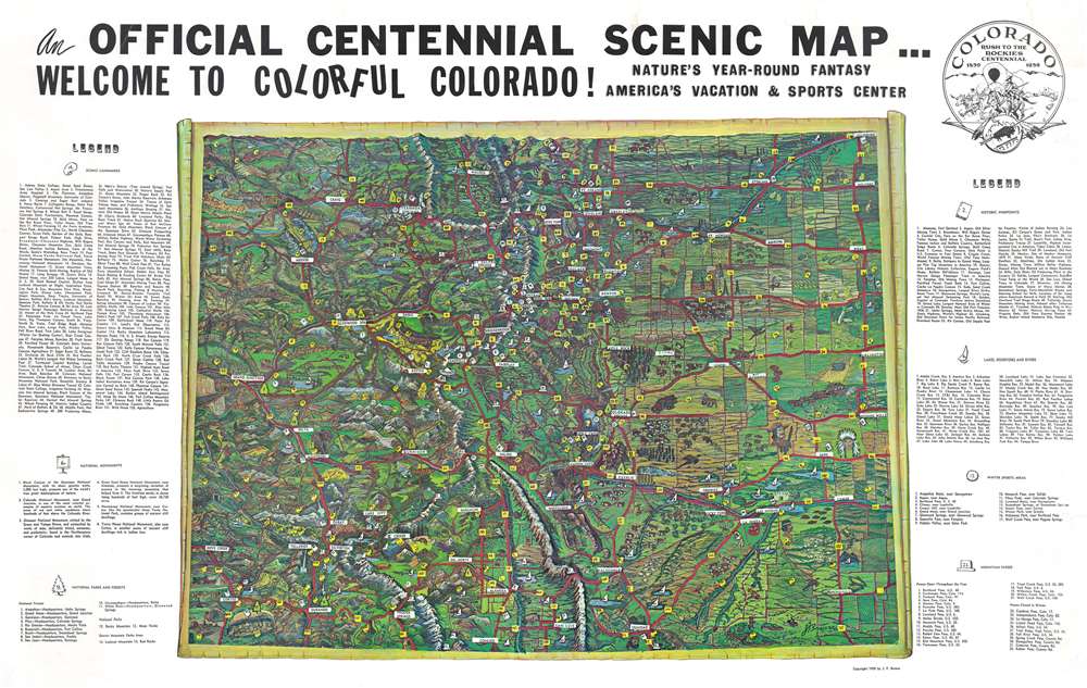
An Official Centennial Scenic Map...Welcome to Colorful Colorado! Nature's Year-Round Fantasy. America's Vacation and Sports Center.
1959 (dated) 21.25 x 34 in (53.975 x 86.36 cm) 1 : 1067800
1959 (dated) 21.25 x 34 in (53.975 x 86.36 cm) 1 : 1067800
Description
This is a 1959 J.F. Brewer pictorial map of Colorado celebrating the centennial of the Pike's Peak Gold Rush. Spectacularly illustrated, Brewer evokes Colorado's stunning landscape. He blends all the colors found around the state to breathe life into the work. Aspects of Colorado's history, including oil derricks, mines, and frontier forts are juxtaposed with more contemporary creations, like national parks and forests, and even the Royal Gorge Bridge. Extensive numerical indexes are situated on the left and right. Noted scenic landmarks, ski areas, mountain passes, historic sites, and national forests, monuments, and parks.
The Pike's Peak Gold Rush
The Pike's Peak Gold Rush, also known as the Colorado Gold Rush, was a major gold rush in the western United States that began in July 1858. Using the phrase 'Pike's Peak or Bust', as many as 100,000 people flocked to the region, hoping to strike it rich. Ironically, the gold region was eighty miles north of Pike's Peak, but that mountain was a famous landmark in the territory and became spiritual focal point. The rush lasted roughly until the formation of the Colorado Territory in 1861. 1.25 million ounces of gold was extracted in Colorado by 1865. The discovery of this quantity of gold also influenced Congress to establish the Denver Mint.Publication History and Census
This map was created and published by J.F. Brewer in 1959. We note a single cataloged example. It appears in OCLC and is part of the collection at the Denver Public Library.Condition
Very good. Closed margin tears professionally repaired on verso. Closed tear extending one-quarter (1/4) inch into printed area professionally repaired on verso. Exhibits slight dampstaining in upper right corner just barely effecting printed image.
References
OCLC 16743631.