This item has been sold, but you can get on the Waitlist to be notified if another example becomes available, or purchase a digital scan.
1851 Tallis and Rapkin Map of Central America
CentralAmerica-tallis-1851$100.00

Title
Central America.
1851 (undated) 10.5 x 13 in (26.67 x 33.02 cm) 1 : 3801600
1851 (undated) 10.5 x 13 in (26.67 x 33.02 cm) 1 : 3801600
Description
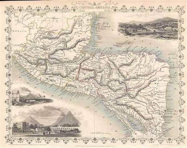
This is a highly decorative 1851 map of Central America by John Tallis and John Rapkin. The map depicts from southern Mexico and the Yucatan peninsula south to extreme northern Costa Rica. Mexico, Belize (Belise), Guatemala, Honduras, El Salvador (Salvador), Nicaragua, and Costa Rica are labeled, as well as both the Pacific and Atlantic Oceans and numerous islands along the Atlantic coast. Lake Nicaragua, the largest lake in Central America, is depicted. Three beautiful vignettes are included. Two of the vignettes, located in the lower left corner, depict the volcano of Izalco (Isalco), which is in El Salvador and the Great Square of the Antigua in Guatemala. The vignette in the upper right corner presents a scene from Belize (Belise). The vignette illustrates a scene in a bay, troubled by rough seas. Several boats, including a row boat with two people in it, and four sail boats, are in the bay making their way toward the safety of the harbor. Two large sailing ships are already moored along the coastline, which is very lush and several buildings are depicted. The map is surrounded by a vine motif border.
The map was engraved by John Rapkin and the illustrations were drawn by Henry Winkles and engraved by G.R. Manwaring for John Tallis's 1851 Illustrated Atlas.
The map was engraved by John Rapkin and the illustrations were drawn by Henry Winkles and engraved by G.R. Manwaring for John Tallis's 1851 Illustrated Atlas.
Cartographer
John Tallis and Company (1838 - 1851) published views, maps, and atlases in London from roughly 1838 to 1851. Their principal works, expanding upon the earlier maps of John Cary and Aaron Arrowsmith, include an 1838 collection of London Street Views and the 1849 Illustrated Atlas of the World. The firm’s primary engraver was John Rapkin, whose name and decorative vignettes appear on most Tallis maps. Due to the embellishments typical of Rapkin's work, many regard Tallis maps as the last bastion of English decorative cartography in the 19th century. Although most Tallis maps were originally issued uncolored, it was not uncommon for 19th century libraries to commission colorists to "complete" the atlas. The London Printing and Publishing Company of London and New York bought the rights for many Tallis maps in 1850 and continued issuing his Illustrated Atlas of the World until the mid-1850s. Specific Tallis maps later appeared in innumerable mid to late-19th century publications as illustrations and appendices. More by this mapmaker...
Source
Tallis, J., The Illustrated Atlas, And Modern History Of The World Geographical, Political, Commercial & Statistical, 1851.
Condition
Very good. Blank on verso.
References
Rumsey 0466.073. OCLC 699498757.