This item has been sold, but you can get on the Waitlist to be notified if another example becomes available, or purchase a digital scan.
1851 Black Map of Greater Germany (Germany, Holland, Belgium, Bohemia, Austria)
CentralEurope-black-1849$50.00

Title
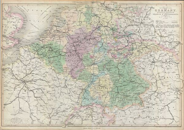
Map of Central Europe embracing Germany, Holland, Belgium, France, Switzerland; showing the Roads, Canals, and Railways.
1849 (dated) 17.25 x 24.25 in (43.815 x 61.595 cm)
1849 (dated) 17.25 x 24.25 in (43.815 x 61.595 cm)
Description
A fine example of Adam and Charles Black's 1851 map of central europe. The map covers from Hamburg to Lake Geneva. Includes the modern day countries of Germany, Netherlands, Belgium, France, Poland, the Czech Republic and Austria.
This map is made in the year following the european Revolutions of 1848. These liberal uprising swept all though europe, except Russia and the United Kingdom. Germany was particularly affected by the March Revolution of 1848. These Revolutions were nationalist pro-German, pan-German, declarations of discontent with the archaic autocratic political structure that dated to the 39 original German states established under the Holy Roman empire. The years following the violent suppression of the March Revolution saw a vast middle class exodus from the German states to the United States, leading to 'Germantown USA,' and popular interest among Americans in the Fatherland.
Throughout, the map identifies various cities, towns, rivers, lakes, roadways and an assortment of additional topographical details. Map is hand colored in pink, green, blue and yellow pastels to define boundaries. The map is engraved by W. Hughes and issued as plate no. 20 in Black's General Atlas.
Cartographer
Charles and Adam Black (fl. 1807 - present) were map and book publishers based in Edinburgh. Charles and his uncle, Adam, both of Edinburgh, Scotland, founded their publishing firm in 1807. They published a series of maps and atlases throughout the 19th century. In addition to an array of atlases, the Black firm is known for their editions of the Encyclopedia Britannica (1817 - 1826) and the first publishing of Sir Walter Scott's novels in 1854. In 1889 the A. & C. Black publishing house moved to London where it remains in operation to this day. More by this mapmaker...
Source
Black, A. and C., General Atlas Of The World, 1849.
Condition
Very good. Original centerfold. Slight wear on edges. Verso repair on centerfold. Overall toning.
References
Rumsey 2305.027 (1854 edition). Philips (atlases) 4334.