This item has been sold, but you can get on the Waitlist to be notified if another example becomes available, or purchase a digital scan.
1849 Black Map of Greater Germany (Germany, Holland, Belgium, Bohemia, Austria)
CentralEurope-black-1851$50.00

Title
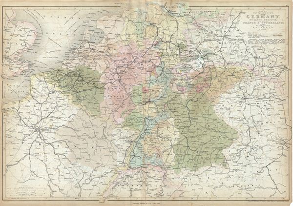
Map of Central Europe embracing Germany, Holland, Belgium, France, Switzerland; showing the Roads, Canals, and Railways.
1849 (dated) 17.5 x 24.5 in (44.45 x 62.23 cm)
1849 (dated) 17.5 x 24.5 in (44.45 x 62.23 cm)
Description
This is a fine example of Adam and Charles Black's 1851 map of central europe. The map covers from Hamburg to Lake Geneva, including the modern day countries of Germany, Netherlands, Belgium, France, Poland, the Czech Republic and Austria.
This map was made in the years following the european Revolutions of 1848. These liberal uprising swept all though europe, except Russia and the United Kingdom. Germany was particularly affected by the March Revolution of 1848. These Revolutions were nationalist pro-German, pan-German, declarations of discontent with the archaic autocratic political structure that dated to the 39 original German states established under the Holy Roman empire. The years following the violent suppression of the March Revolution saw a vast middle class exodus from the German states to the United States, leading to 'Germantown USA,' and popular interest among Americans in the Fatherland.
Throughout, the map identifies various cities, towns, rivers, lakes, roadways and an assortment of additional topographical details. This map was engraved by W. Hughes and issued as plate no. XX in the 1851 edition of Black's General Atlas of the World.
CartographerS
Charles and Adam Black (fl. 1807 - present) were map and book publishers based in Edinburgh. Charles and his uncle, Adam, both of Edinburgh, Scotland, founded their publishing firm in 1807. They published a series of maps and atlases throughout the 19th century. In addition to an array of atlases, the Black firm is known for their editions of the Encyclopedia Britannica (1817 - 1826) and the first publishing of Sir Walter Scott's novels in 1854. In 1889 the A. & C. Black publishing house moved to London where it remains in operation to this day. More by this mapmaker...
William Hughes (c. 1818 - May 21, 1876) was a cartographer, engraver, lithographer, printer, and publisher active in London during the middle part of the 19th century. Hughes enjoyed and long and varied cartographic career. He was elected a Fellow of the Royal Geographical Society in 1838 and, from about 1840, taught geography and mapmaking at St. Johns College for Civil Engineers. He later taught the same at both Queens College and Kings College, London. For a time he was employed as a map librarian for the British Museum. Hughes began engraving maps around 1839 and worked with most of the prominent British map and atlas publishers of his era, including but not limited to Charles Knight, A. and C. Black, George Philip, William Cassell, and others. Learn More...
Source
Black, A. and C., General Atlas Of The World, (Edinburgh) 1851.
Condition
Good. Minor overall toning. Blank on verso. Minor foxing and offsetting. Verso repair on original centerfold and near top margin. Large stain over part of France and Saxony.
References
Rumsey 2305.027 (1854 edition). Philips (atlases) 4334.