This item has been sold, but you can get on the Waitlist to be notified if another example becomes available, or purchase a digital scan.
1869 Map of Central Park, New York City
CentralParkGuide-mcny-1869$150.00

Title
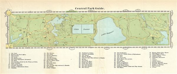
Central Park Guide.
1869 (undated) 7.5 x 16.5 in (19.05 x 41.91 cm) 1 : 10800
1869 (undated) 7.5 x 16.5 in (19.05 x 41.91 cm) 1 : 10800
Description
A rare hand-colored map of New York City's Central Park prepared and printed for inclusion in the 1869 edition of Valentine's Manual of the Corporation of the City of New York. It depicts the park as a whole and includes pathways, lakes, buildings, individual trees, rocks, and elevation measurements. The streets and avenues surrounding the park are labeled as are the various landmarks of Central Park: the Knoll, The Ramble, the Mall, and some 55 others.
This extraordinary map reveals Central Park as conceived by the Landscape Architects, and indeed 'artists,' Vaux and Olmsted. Vaux and Olmsted were awarded the task of designing Central Park in 1853 by the City Common Council. Olmsted's vision drove the overall design while Vaux concentrated his attentions on bridges, buildings, and other structures within the park. The creation of Central Park, which was to consist of some 800 acres of public forest, pathways, promenades, lakes, bridges, and meadows, was a seminal moment in civic urban design. The park itself was designed as a whole with every tree, pond, and bench meticulously planned. Olmsted wrote: 'Every foot of the parks surface, every tree and bush, as well as every arch, roadway, and walk and been placed where it is for a purpose.' Historian Gloria Deak writes,There was a staggering amount of work to be done to transform the area into a blend of pastoral and woodland scenery. This involved the design and construction of roadways, tunnels, bridges, arches, stairways, fountains, benches, lamp posts, gates, fences and innumerable other artifacts. It also involved the supervision of an army of about five thousand laborers…Olmsted, to whom most of the credit goes, insisted on seeing the multidimensional project as a single work of art, which he was mandated to create. For this purpose, he ventured to assume to himself the title of 'artist.'Today, because of Vaux and Olmsted's efforts, New York Yorkers, ourselves included, have the privilege of enjoying what is, perhaps, the finest example of a planned urban public recreation area in the world.
This extraordinary map reveals Central Park as conceived by the Landscape Architects, and indeed 'artists,' Vaux and Olmsted. Vaux and Olmsted were awarded the task of designing Central Park in 1853 by the City Common Council. Olmsted's vision drove the overall design while Vaux concentrated his attentions on bridges, buildings, and other structures within the park. The creation of Central Park, which was to consist of some 800 acres of public forest, pathways, promenades, lakes, bridges, and meadows, was a seminal moment in civic urban design. The park itself was designed as a whole with every tree, pond, and bench meticulously planned. Olmsted wrote: 'Every foot of the parks surface, every tree and bush, as well as every arch, roadway, and walk and been placed where it is for a purpose.' Historian Gloria Deak writes,
Cartographer
David T. (Thomas) Valentine (1801 - 1869) served as the Clerk of the Common Council of New York City. He edited and published a series of New York City almanacs and fact books entitled Manual of the Corporation of The City of New York. Valentine's Manual, as it came to be called, included facts about the City of New York, City Council information, city history, and reported on the progress of public works such as Central Park. The production of this annual manual was the responsibility of the Clerk of the City of New York, a position held at different times by D. Valentine and by Joseph Shannon (fl. c. 1850 - 1869), who also produced a similar manual. Valentine used his manual to reproduce some of the rarest and most important maps of New York City ever created. More by this mapmaker...
Condition
Very good. Minor wear and verso repair along original fold lines. Some toning and spotting.
References
Deak, Gloria Gilda, Picturing America: 1497-1899. Vol. 1. Princeton, New Jersey: Princeton University Press, 1988. pp. 535-536; Peters, Harry T. America on Stone. U.S.: Doubleday, Doran, 1931. pp. 350-356. (Sarony, Major & Knapp).