This item has been sold, but you can get on the Waitlist to be notified if another example becomes available, or purchase a digital scan.
1869 Appleton View of the Terrace and Lake in Central Park, New York City
CentralParkLake-appleton-1869$125.00

Title
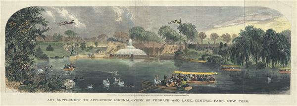
Art Supplement to Appleton's Journal, View of Terrace and Lake, Central Park, New York.
1869 (dated) 10 x 28 in (25.4 x 71.12 cm)
1869 (dated) 10 x 28 in (25.4 x 71.12 cm)
Description
This is a charming 1869 view of the Bethesda Terrace and Lake in Central Park, issued by D. Appleton. The Bethesda Terrace is located roughly at 72nd streets in the heart of New York City's Central Park. The view beautifully depicts the Terrace from a south facing perspective over 'the Lake' towards the Bethesda Fountain. It is important to realize that this part of the park was merely planned, not completed, when this view was made. The central sculpture, 'Angel of the Waters' by Emma Stebbins, was not completed until 1873, and is missing from this view. The arched double staircase behind the fountain was designed by Jacob Wrey Mould. Vaux and Olmsted envisioned the terrace as a meeting place in the heart of the park. Today it is one of the most picturesque parts of the park and a popular hangout for artists and musicians.
Vaux and Olmsted were awarded the task of designing Central Park in 1853 by the City Common Council. Olmsted's vision drove the overall design while Vaux concentrated his attentions on bridges, buildings, and other structures within the park. The creation of Central Park, which was to consist of some 800 acres of public forest, pathways, promenades, lakes, bridges, and meadows, was a seminal moment in civic urban design. The park itself was designed as a whole with every tree, pond, and bench meticulously planned. Olmsted wrote: 'Every foot of the parks surface, every tree and bush, as well as every arch, roadway, and walk and been placed where it is for a purpose.'
Historian Gloria Deak writes,
This view was 'Entered, according to Act of Congress, in the 1869 by D. Appleton and Co., in the Clerk's Office of the District Court of the United States, for the Southern District of New York and was issued as an art supplement to Appletons' Journal.
Vaux and Olmsted were awarded the task of designing Central Park in 1853 by the City Common Council. Olmsted's vision drove the overall design while Vaux concentrated his attentions on bridges, buildings, and other structures within the park. The creation of Central Park, which was to consist of some 800 acres of public forest, pathways, promenades, lakes, bridges, and meadows, was a seminal moment in civic urban design. The park itself was designed as a whole with every tree, pond, and bench meticulously planned. Olmsted wrote: 'Every foot of the parks surface, every tree and bush, as well as every arch, roadway, and walk and been placed where it is for a purpose.'
Historian Gloria Deak writes,
'There was a staggering amount of work to be done to transform the area into a blend of pastoral and woodland scenery. This involved the design and construction of roadways, tunnels, bridges, arches, stairways, fountains, benches, lamp posts, gates, fences and innumerable other artifacts. It also involved the supervision of an army of about five thousand laborers…Olmsted, to whom most of the credit goes, insisted on seeing the multidimensional project as a single work of art, which he was mandated to create. For this purpose, he ventured to assume to himself the title of 'artist'Today, because of Vaux and Olmsted's efforts, New York Yorkers, ourselves included, have the privilege of enjoying what is, perhaps, the finest example of a planned urban public recreation area in the world.
This view was 'Entered, according to Act of Congress, in the 1869 by D. Appleton and Co., in the Clerk's Office of the District Court of the United States, for the Southern District of New York and was issued as an art supplement to Appletons' Journal.
Cartographer
D. Appleton (fl. 1830 - 1873) was a New York based map publisher operating in the middle part of the 19th century. His most common publications were school geography texts published under his own name or the name of his associate S. S. Cornell. He also published a series of pocket maps relating to the Civil War and a few lesser known wall maps. More by this mapmaker...
Source
Appleton, D., Appletons' Journal (New York), 1870.
Condition
Very good. Minor wear and creasing over original fold lines. Professionally flattened and backed with archival tissue.