This item has been sold, but you can get on the Waitlist to be notified if another example becomes available, or purchase a digital scan.
1865 War Dept. Map of Central Virginia Illustrating General Grant's Campaigns
CentralVirginia-wardept-1865$375.00

Title
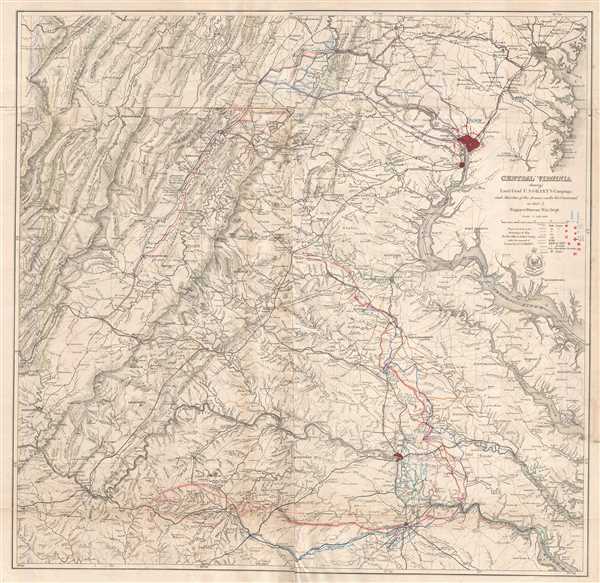
Central Virginia Showing Lieut. Gen'l U.S. Grant's Campaign and Marches of the Armies under his Command in 1864-5.
1865 (dated) 31.5 x 32.5 in (80.01 x 82.55 cm) 1 : 350000
1865 (dated) 31.5 x 32.5 in (80.01 x 82.55 cm) 1 : 350000
Description
This is a separate issue 1865 United States War Department map of Lieutenant General Ulysses S. Grant's campaigns in Virginia in 1864 and 1865. Including Washington, D.C., Alexandria, Baltimore, Richmond, and Petersburg, the map depicts the region from Martinsburg, Maryland to Dinwiddie Court House, Virginia and from Lexington and Franklin, Virginia to Yorktown and Heathsville, Virginia. Created by order of the Secretary of War for the officers of the U.S. Army under the command of General Grant, troop movements throughout the region are traced, including those of the Nineteenth, Second, Fifth, Sixth, Ninth, Tenth, Eighteenth, Twenty-fourth, and Twenty-fifth Corps, along with General Philip Sheridan's cavalry.
The Overland Campaign and the End of the American Civil War
Illustrating General Grant's movements following his nomination by President Lincoln to the position of General-in-Chief of the United States Army, the Overland Campaign is depicted in detail. From the crossing of the Rapidan River on May 4, 1864, each of the battles fought in the campaign are labeled in blue ink by date; most are located near the town or site that gives the battle its name, although some are not easily recognizable. These battles include the Battle of the Wilderness, the Battle of Spotsylvania Court House, the Battle of North Anna, and the Battle of Cold Harbor. Each battle saw Grant try to push his army between that of General Robert E. Lee and the Confederate capital, Richmond. Grant hoped that by separating Lee from Richmond, both would wither, and the war would be won. Lee, however, masterfully parried each of Grant's moves to the southeast, which led to the aforementioned series of battles culminating in the Siege of Petersburg.
The siege lasted over nine months and was eventually broken after Lee abandoned the city on March 25, 1865, which immediately caused the evacuation of Richmond. Lee and his army fled to the west, hoping to regroup with General Joseph E. Johnston's army in North Carolina. Grant and the Army of the Potomac, however, were in hot pursuit. General Philip Sheridan's cavalry caught Lee's army and blocked its retreat, forcing Lee to stand and fight one last battle, at Appomattox Court House, in the hope of breaking free of the encirclement and continuing the fight further south. Even so, Grant's force outnumbered Lee's, and, realizing that he was cut off, Lee chose to surrender his army, effectively ending the American Civil War. Lee's surrender at Appomattox is noted here, in red ink, in the lower left quadrant.
A highly detailed map, myriad locations throughout the region are labeled, including cities, towns, and villages. Rivers and streams are also labeled, along with other physical features. Civil War notations are not limited to the Overland Campaign and subsequent events, as the Battles of Bull Run , Fredericksburg, and other are noted, though not always by name or by date.
This map was prepared by order of the Secretary of War and created by the Engineer Bureau of the War Department in 1865. This map is extremely rare on the market as we have been able to locate only a handful of other examples that have ever been available. It is present in institutional collections.
Condition
Very good. Even overall toning. Repaired tear extending four inches along bottom fold professionally repaired on verso. Blank on verso.
References
Stephenson, R. W., Civil War Maps; an Annotated List of Maps and Atlases in Map Collections of the Library of Congress, 514. Rumsey 3854.000. OCLC 50720745.