This item has been sold, but you can get on the Waitlist to be notified if another example becomes available, or purchase a digital scan.
1764 Bellin Map of Charleston, South Carolina
Charleston-bellin-1764$325.00

Title
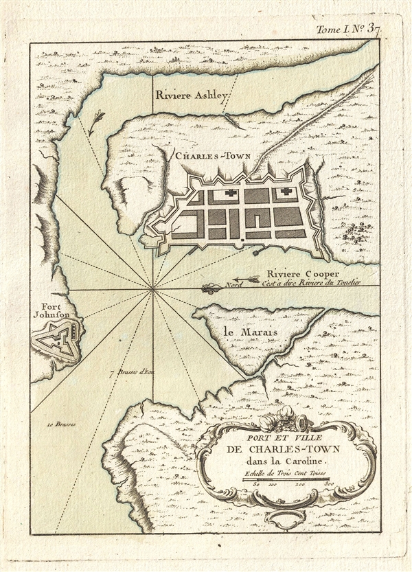
Port et Ville de Charles-Town dans la Caroline.
1764 (undated) 9.5 x 6.5 in (24.13 x 16.51 cm) 1 : 16000
1764 (undated) 9.5 x 6.5 in (24.13 x 16.51 cm) 1 : 16000
Description
One of the earliest obtainable maps of Charleston, this is Jacques Nicholas Bellin's 1764 Port et Ville de Charles-Town dans la Caroline. Oriented to the west, this fine early map details the convergence of the Cooper and Ashley Rivers. The town of Charleston is clearly laid down on the west bank of the Cooper River. Charleston's design follows the fortifications as designed by William De Brahm. Often called 'De Braham's Folly' the fortifications, of which only a few are illustrated here, were audaciously sophisticated and, had they been enacted would have transformed the peninsula of Charleston into the most sophisticated military enceinte in British North America. As it happened fortifications were only partially completed between 1755 and 1757. Across the Ashley River we can see Fort Johnson. Across the Cooper River Bellin identifies Le Marais, what is today Hog Island. This map was issued to accompany the 1764 edition of Bellin's Petit Atlas Maritime.
Cartographer
Jacques-Nicolas Bellin (1703 - March 21, 1772) was one of the most important cartographers of the 18th century. With a career spanning some 50 years, Bellin is best understood as geographe de cabinet and transitional mapmaker spanning the gap between 18th and early-19th century cartographic styles. His long career as Hydrographer and Ingénieur Hydrographe at the French Dépôt des cartes et plans de la Marine resulted in hundreds of high quality nautical charts of practically everywhere in the world. A true child of the Enlightenment Era, Bellin's work focuses on function and accuracy tending in the process to be less decorative than the earlier 17th and 18th century cartographic work. Unlike many of his contemporaries, Bellin was always careful to cite his references and his scholarly corpus consists of over 1400 articles on geography prepared for Diderot's Encyclopedie. Bellin, despite his extraordinary success, may not have enjoyed his work, which is described as "long, unpleasant, and hard." In addition to numerous maps and charts published during his lifetime, many of Bellin's maps were updated (or not) and published posthumously. He was succeeded as Ingénieur Hydrographe by his student, also a prolific and influential cartographer, Rigobert Bonne. More by this mapmaker...
Source
Bellin, J. N., Petite Atlas Maritime, Vol. 1, (Paris) 1764.
Bellin's Petit Atlas Maritime was a five volume atlas of all parts of the world published in Paris in 1764. The atlas is a combination of fresh material and previous issued Bellin maps. The breakdown of volumes is as follows: Volume I: North America and the Caribbean (102 Maps), Volume II: South America (89 maps), Volume III: Asia and Africa (127 maps), Volume IV: Europe (130 maps), and Volume V: France (132 maps), for a total of 580 maps and plans. This important atlas marked a major transition in European nautical mapping. It's significance is most accentuated by comparison to Bellin's other great atlas, L’Hydrographie Française, a large format work much akin to Dutch nautical atlases of the previous century. The Petit Atlas Maritime, on the other hand, was issued in a more compact format that allow for a diverse wealth of individual maps. Stylistically, it had more in common with European road atlases than with other nautical atlases of the period. As the largest collection of plans of harbors and nautical maps available at the time of publication, the Petite Atlas Maritime work proved popular with navigators and armchair adventurers alike. Its universal appeal gave rise to new convention in maritime mapping. The atlas was sponsored by the Duc de Choiseul. J. Arrivet is listed as engraver on the chart index pages, but there is a great likelihood he also engraved the maps and plans.
Condition
Very good. Pressmark. Blank on verso. Wide margins.
References
Rumsey 6903.045.