This item has been sold, but you can get on the Waitlist to be notified if another example becomes available, or purchase a digital scan.
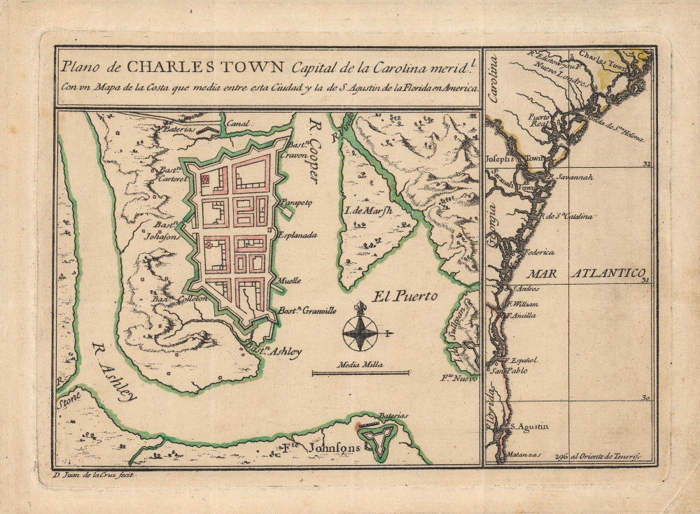
1753 Juan de la Cruz Map of Charleston and Charleston Harbor, South Carolina
Charleston-juandelacruz-1753$4,250.00

Title
Plano de Charles Town capital de la Carolina Medl. con un mapa de la costa que media entre esta ciudad y la de S. Agustin de la Florida en America.
1753 (undated) 6.5 x 9 in (16.51 x 22.86 cm) 1 : 66400
1753 (undated) 6.5 x 9 in (16.51 x 22.86 cm) 1 : 66400
Description
This is Juan de la Cruz's important and rare c. 1753 plan of Charleston, South Carolina. It is one of the earliest printed maps of Charleston, and perhaps the earliest specific printed map of Charleston. It updates the city plan included, via inset, on the unobtainable 1711 Edward Crisp map. As such, it reflects the precarity of the settlement just 30 years after its founding, as a distant colonial outpost, heavily fortified against anticipated attacks.
The map at right covers the coast from Charleston to St. Augustin and Matanzas in Florida. The close proximity of the rival Spanish and English colonies guaranteed that these waters and coasts would be contested, explaining the proliferation of forts (though some of these in reality were hardly worthy of the name).
Still, Juan de la Cruz modified Crisp's map in important ways, most notably shifting the orientation from west to north, elaborating the surrounding countryside, and modifying the structures inside the walls somewhat. These facts suggest that de la Cruz was primarily inspired by Crisp's map but included additional information, likely from written accounts, to 'update' the map. Similarly, de la Cruz has shifted the orientation and significantly improved upon the secondary map of the coastline that appeared in 'A compleat description…,' drawing on improved maps that would have become available in the intervening years. The inclusion of certain features, such as (Fort) Matanzas, built 1742 and Savannah, Georgia, founded 1733, supports this interpretation, but also underscores just how current the map was.
A Closer Look
The sheet contains two maps, a larger one at left of Charleston and a tall, narrow map at right of the Atlantic coast. In the former, Charleston is surrounded by fortified walls, bastions, and batteries, a reminder of the seaborne and landward threats to the settlement. At bottom, Fort Johnson protects the harbor and the approach to the settlement. The 'New Fort' on Sullivan's Island at right is likely the uncompleted fort which became the site of a battle early in the American Revolutionary War (1775 - 1783), later renamed Fort Moultrie after the American commander in that fight.The map at right covers the coast from Charleston to St. Augustin and Matanzas in Florida. The close proximity of the rival Spanish and English colonies guaranteed that these waters and coasts would be contested, explaining the proliferation of forts (though some of these in reality were hardly worthy of the name).
Cartographic Influences
The present map is most likely based on the 'Crisp Map' of Charleston, published c. 1711 as part of a large sheet containing multiple maps titled 'A compleat description of the province of Carolina in 3 parts.' Most examples of the Crisp Map in circulation today are in fact an early 19th century reimagination. The present map much more closely resembles Crisp's 1711 map, which was the earliest known map to depict the first city walls of Charleston.Still, Juan de la Cruz modified Crisp's map in important ways, most notably shifting the orientation from west to north, elaborating the surrounding countryside, and modifying the structures inside the walls somewhat. These facts suggest that de la Cruz was primarily inspired by Crisp's map but included additional information, likely from written accounts, to 'update' the map. Similarly, de la Cruz has shifted the orientation and significantly improved upon the secondary map of the coastline that appeared in 'A compleat description…,' drawing on improved maps that would have become available in the intervening years. The inclusion of certain features, such as (Fort) Matanzas, built 1742 and Savannah, Georgia, founded 1733, supports this interpretation, but also underscores just how current the map was.
Publication History and Census
This map was drawn by one Juan de la Cruz and published in the mid-18th century. Existing catalog listings note the maker as Juan de la Cruz Cano y Olmedilla, but this would be very early in his career, suggesting the possibility of a different cartographer. The map may have appeared in Diego Davin's Cartas edificantes y curiosas escritas de las Missiones Estrangeras..., a partial translation of the French Jesuit periodical Lettres edifiantes et curieuses, ecrites des missions etrangeres, par quelques missionaires de la Compagnie de Jesus published in 1753. It is only listed among the holdings of the University of South Carolina and the Charleston Library Society. No market history.Condition
Very good. Original fold lines visible. Tape residue on verso towards edge.
References
OCLC 17924696.


