This item has been sold, but you can get on the Waitlist to be notified if another example becomes available, or purchase a digital scan.
1936 George Annand Pictorial Map of Manhattan, New York City
ChartManhattan-annand-1936$175.00

Title
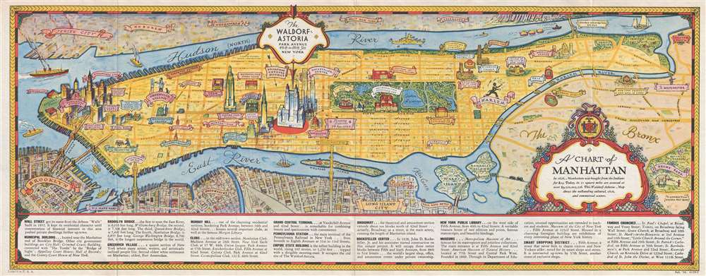
A Chart of Manhattan.
1936 (dated) 9 x 22.5 in (22.86 x 57.15 cm) 1 : 40000
1936 (dated) 9 x 22.5 in (22.86 x 57.15 cm) 1 : 40000
Description
This is a 1936 George Annand pictorial map of the borough of Manhattan in New York City. The map depicts the region from Battery Park and New York Harbor to the Bronx and from New Jersey to Brooklyn and Queens. Originally published by the Waldorf Astoria Hotel, the Waldorf, located on Park Avenue between 49th and 50th Streets, is of course the map's focal point and is illustrated in profile. Other Manhattan landmarks are also shown in profile, including the Empire State Building, the Chrysler Building, the Metropolitan Museum of Art, the Museum of Natural History and Grant's Tomb. Central Park, complete with the Croton Reservoir and the Central Park Zoo, are also highlighted, along with Riverside Park, Inwood Hill Park, Washington Square, and Battery Park. The Williamsburg, Manhattan, Brooklyn, and George Washington Bridges are also illustrated. Yankee Stadium and the 'Bronx Park' where the New York Botanical Garden and the Bronx Zoo are located, are also illustrated in the Bronx. Only the major streets in Manhattan are illustrated and labeled, along with several neighborhoods, including the Financial District, Greenwich Village, Murray Hill, the Theatre District, Chelsea, and Harlem. Astoria and Long Island City are identified in Queens, with Greenpoint the only neighborhood identified in Brooklyn. The U.S. Navy Yard is also noted along the East River, and what appears to be a battleship is heading north up the Hudson River. Information about locations throughout Manhattan is situated along the bottom border and includes notes about the museums, the New York Public Library, Broadway, and Rockefeller Center, along with others.
This map was created by George Annand and published by the Waldorf-Astoria Hotel in 1936.
This map was created by George Annand and published by the Waldorf-Astoria Hotel in 1936.
Cartographer
George Annand (June 9, 1890 - September, 1980) was an American graphic artist and cartographer active in New York during the middle part of the 20th century. Annand was born in Croswell, Michigan, the sun of a Scottish immigrant doctor who immigrated to the United States via Canada. He received his early education at a one-room schoolhouse in Croswell before he and his parents relocated to Detroit. It was in Detroit that Annand was first introduced to the arts, enrolling in Art School. Later, as a young man, Annand move to New York City, where he continued his artistic studies at the Art Students League. In 1920 he married a childhood friend, Elizabeth Sinclair, who had been widowed during World War I. He adopted Elizabeth's two children and she and Annand shortly thereafter became pregnant with a third child. With a family to support and another 'bun in the oven' Annand turned to the booming New York advertising industry, taking work with the National Biscuit Company (NABISCO). He did well at NABISCO painting, as he liked to joke 'Fig Newtons in their native habitat.' He also took freelance work designing illustrated book covers. One of his first such jobs was illustrating a cover for C. E. Montague's Right off the Map. Naturally, given the nature of the work, the cover featured a map incorporating pictorial elements with aspects of baroque era cartography - Annand's first pictorial map. The Wall Street Crash of 1929 hit Annand's interests hard and he lost his job a Nabisco. Refusing WPA work for reasons of personal pride, Annand managed to get by on odd illustration contracts for various companies including publishers like Doubleday, Doran, and Charles Scribner, as well as pictorial map work for the Waldorf Astoria Hotel, General Foods, Sinclair Oil, and more. His cartographic work eventually drew the attention of the Chicago based map publishing giant Rand McNally, who commissioned him to produce two of their popular 'Romance Maps.' During and after World War II business began to pick up again and Annand produced a huge corpus of pictorial maps. His style combined decorative elements from 16th century Dutch decorative cartography, fine calligraphy, and more contemporary pictorial work. He wanted his maps are noteworthy for their clarity and the sense of space they convey. Annand was, according to Stephen Horsby in Picturing America: The Golden Age of Pictorial Maps, 'a cartographer's cartographer.' Annand continued to produce pictorial maps until forced to sop due to cataract surgery in 1970. He died 10 years later in 1980, at 90 years old. More by this mapmaker...
Condition
Very good. Even overall toning. Light wear along original fold lines. Text on verso.
References
Rumsey 8874.002.