This item has been sold, but you can get on the Waitlist to be notified if another example becomes available, or purchase a digital scan.
1659 Du Val Map of the Pilgrimage of Santiago de Compostela
CheminStJacques-duval-1659$4,750.00

Title
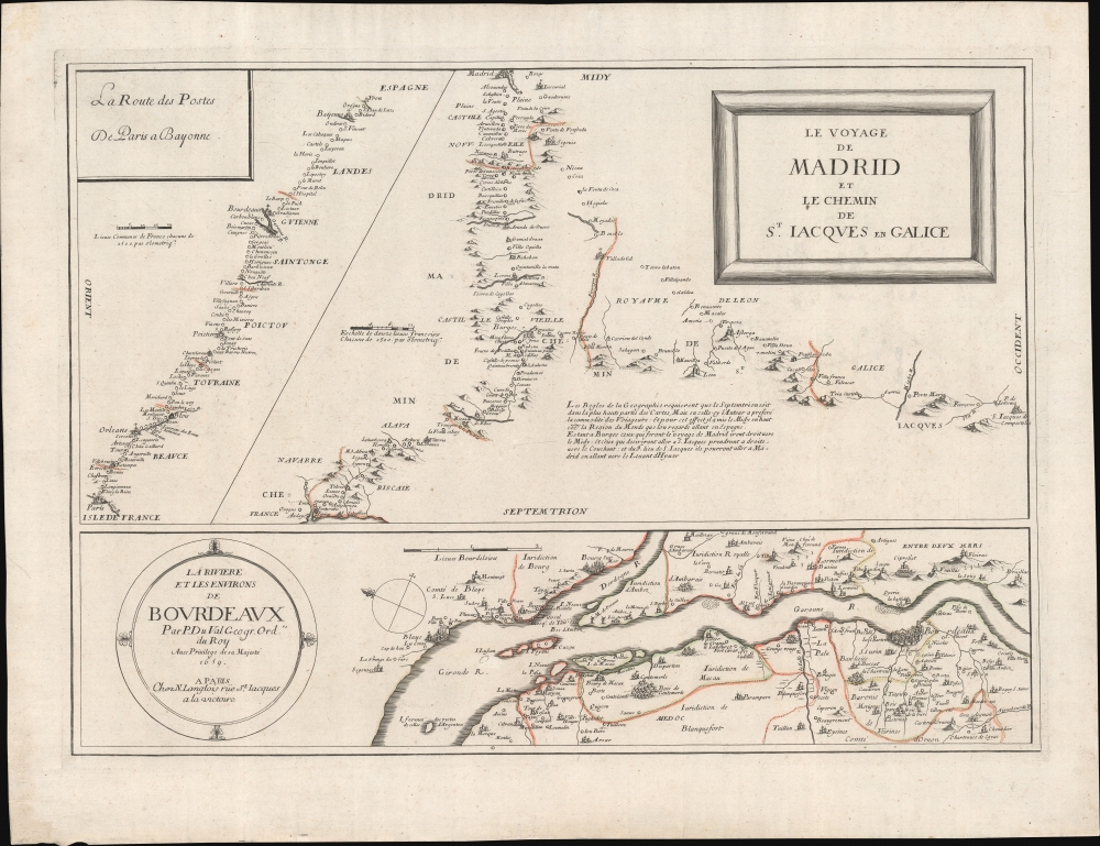
Le Voyage de Madrid et La Chemin de S. Iacques en Galice. / La Riviere et les Environs de Bovrdeavx. / La Route des Postes de Paris a Bayonne.
1659 (dated) 17 x 22.5 in (43.18 x 57.15 cm)
1659 (dated) 17 x 22.5 in (43.18 x 57.15 cm)
Description
Of the utmost importance and rarity, this is the only map to illustrate the pilgrimage route to Santiago de Compostela (Chemin St. Jacques / Way of St. James) to appear during its period of greatest significance. This map was issued in 1659 by Piere Du Val and N. Langlois. It follows closely on the November 7, 1659 signing Treaty of the Pyrenees, which sealed a peace between France and Spain, ending the Franco-Spanish War (1635 - 1659) and opening the pilgrimage routes to French devotees for the first time in nearly 30 years.
A Closer Look
The map offers three maps on a single sheet - all closely related to the Pilgrimage to Santiago de Compostela.- The first and largest illustrates routes from Madrid (Camino de Madrid) and Navarre to Compostela (Camino Francés).
- The second, along the bottom, details the vicinity of Bordeaux, France - a major launching point for French pilgrims en route to the Camino Vasco.
- The third, in the upper left, follows the post routes from Paris, France, through Bordeaux, to the St. Jean de Luz / Irun border with Spain - the origin point of the Camino Vasco.
The Rules of Geography require the North to be in the highest part of the Maps, but in this the Author has preferred the convenience of Travelers: we look at going to Spain. Being in Burgos, those who make the trip from Madrid will go right to the Midy [south]: And those who wish to go to S. Iacques will take a right, towards the West: and from the 9th place of S. Iacques they can go to Madrid by going towards the Levant d'Hyuer.
Les Regles de l Geographie requierent que le Septentrion soit dans la plus haute partie des Cartes, Mais en celle-ci l'Auteur a prefere la commodite des Voiageurs: Et pour cet effect il a mis le Midi en haut coc la Region du Monde que l'on regarde allant en Espagne. Estant a Burgos ceux qui feront le voyage de Madrid iront droituers le Midy: Et ceus qui desireront aller a S. Iacques prendront a droit, vers la Couchant : et du 9 lieu de S. Iacques ils pourront aller a Madrid en allant vers le Levant d'Hyuer.
The Pilgrimage of Santiago de Compostela
The pilgrimage route to Santiago de Compostela, also known as the Chemin St. Jacques in French and the Way of Saint James in English, is a late mediaeval pilgrimage route running from various points around Europe to the cathedral of Santiago de Compostela, believed to be the resting place of the relics of St. James the Elder, the first martyred apostle. It is considered one of the three great Catholic pilgrimages, following Jerusalem and Rome. Like these other pilgrimage destinations, Compostela, located in the northwesternmost part of Spain, lay far from Europe's most populous Christian lands, and the route to get there was both long and arduous. Pilgrims typically traveled by foot, wearing distinctive garb to mark themselves: cape, wide brimmed hat, and a scallop shell. They relied heavily on the charity of strangers as well as refuges established by the church to assist them. The route to Compostela reached its height in the 15th century, when Ottoman conquests closed the Holy Land to most Europeans. Over the subsequent centuries, the Compostela pilgrimage waxed and waned in popularity as the constant inter-European wars opened and closed borders. Although largely forgotten in the early 20th century, the routes to Compostela are again crowded with pilgrims and form, in aggregate, Europe's most popular long-distance trek.Publication History and Census
This map was drawn by Pierre du Val and published by N. Langlois in 1659. We are aware of a variant edition bearing the imprint of Jaques Langlet, published in the same year. Gaspard Bailleul published a third edition around 1700. Exceedingly rare, we are aware of only two other known examples: Bibliothèque nationale de France (BnF) and the Bibliotheksverbund Bayern. No history on the private market.CartographerS
Jacques Lagniet (1620 - April 10, 1675) was a French engraver, caricaturist, publisher, and dealer in prints and maps based in Paris. He was best known for middle-market prints focusing on everyday life and lore, as well as socio-critical satire. He was most active from 1647 to 1660 from office at rue St-Martin, parish of St-Nicolas-des-Champs and later near For-l'Évêque, on the Quai de la Mégisserie. He was survived by a daughter, Françoise Perronne Lagniet, who married the engraver, Pierre Picart. More by this mapmaker...
Pierre Du Val (May 19, 1619 - September 29, 1683) was a French cartographer and publisher active in Paris during the middle part of the 17th century. He was born Abbeville, Picardie, France, where his father, also Pierre, was a merchant, consul, and alderman. His mother was Marie Sanson, sister of Nicolas Sanson d'Abbeville (1600-1667), the leading French cartographer of his day. Du Val and probably apprenticed in Sanson's workshops. Afterwards, in Paris, he studied geography under Jean-Baptiste Gault, who later became the Bishop of Marseilles. He counseled M. Henri of Savoye, abbot of St. Sorlin, and M. Gilles Bouraut, bishop of Aire and later Evreux, in matters of science and geography. Du Val became Geographe ordinaire to Louis XIV in 1650. His first atlas, the 1654 Cartes Geographiques Methodiquement Divisees, contained few of his own maps and was mostly compiled from reissues of maps by other cartographers. His early work focused on atlases and geographical treatises, but later, he turned his attentions to large separate issue, often multi-sheet maps. After his death in 1683, his widow, Marie Desmaretz, continued his business at least until 1684, after which it passed to his daughters (either Marie-Angelique or Michelle), who published until at least 1688. He is the elder brother of Placide de Sainte Hélène (1648 - 1734), Placidium Augustinum, an Augustine monk and geographer. Learn More...
Condition
Very good.
References
Bibliothèque nationale de France, FRBNF40600602. Bibliotheksverbund Bayern.