This item has been sold, but you can get on the Waitlist to be notified if another example becomes available, or purchase a digital scan.
1908 Rand McNally City Plan or Map of Chicago, Illinois
Chicago-randmcnally-1908$125.00

Title
Rand McNally and Co.'s New Street Number Guide Map of Chicago.
1908 (dated) 35 x 30.5 in (88.9 x 77.47 cm) 1 : 25344
1908 (dated) 35 x 30.5 in (88.9 x 77.47 cm) 1 : 25344
Description
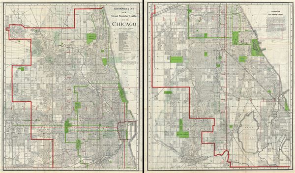
This is an uncommon 1908 pocket map or city plan of Chicago, Illinois by Rand McNally and Company. The Rand McNally Company issued this enormous pocked map to illustrate their home city in incredible detail. The map is printed on two sides of a single sheet of paper. The recto (image above left), details northern Chicago from 33rd street northwards. This section of Chicago includes central Chicago, 'The Loop,' Lincoln Park, the beginnings of the Chicago Park System, and the magnificent Mile. The verso (image above right), details Chicago south of 34th Street, including the southern tier of the Park System, Jackson park (Field Museum), the Midway, Lake Calumet and Wolf Lake.
Selected as a railway hub for most of the American Midwest, Chicago underwent a boom period and was the focus of the world's attention in 1893 during the Chicago World's Fair, or as it is better known, the Columbian Exposition. The map identifies Jackson Park, the location of the fair. It also illustrates the Chicago Park System. The 'Park System,' designed by Olmsted prodigy William Le Baron Jenny in 1871, refers to a network of parks and garden boulevards intended to embrace the city in arms of foliage. Many of these parks and boulevards remain today.
This highly detailed map identifies piers, parks, cemeteries, street addresses, railroads, and an assortment of other topographical features. Individual streets and buildings are identified. Issued and copyrighted by the Rand McNally Company in 1908.
Cartographer
Rand, McNally and Co. (fl. 1856 - present) is an American publisher of maps, atlases and globes. The company was founded in 1856 when William H. Rand, a native of Quincy, Massachusetts, opened a print shop in Chicago. Rand hired the recent Irish immigrant Andrew McNally to assist in the shop giving him a wage of 9 USD per week. The duo landed several important contracts, including the Tribune's (later renamed the Chicago Tribune) printing operation. In 1872, Rand McNally produced its first map, a railroad guide, using a new cost effective printing technique known as wax process engraving. As Chicago developed as a railway hub, the Rand firm, now incorporated as Rand McNally, began producing a wide array of railroad maps and guides. Over time, the firm expanded into atlases, globes, educational material, and general literature. By embracing the wax engraving process, Rand McNally was able to dominate the map and atlas market, pushing more traditional American lithographic publishers like Colton, Johnson, and Mitchell out of business. Eventually Rand McNally opened an annex office in New York City headed by Caleb S. Hammond, whose name is today synonymous with maps and atlases, and who later started his own map company, C. S. Hammond & Co. Both firms remain in business. More by this mapmaker...
Condition
Very good. Minor wear along original fold lines. Printed on both sides. Image above represents two sides of a single sheet of paper.