This item has been sold, but you can get on the Waitlist to be notified if another example becomes available, or purchase a digital scan.
1910 Rand McNally Map of Chicago, Illinois
Chicago-randmcnaly-1910$112.50

Title
New Street Number Guide Map of Chicago.
1910 (dated) 34 x 29 in (86.36 x 73.66 cm) 1 : 25344
1910 (dated) 34 x 29 in (86.36 x 73.66 cm) 1 : 25344
Description
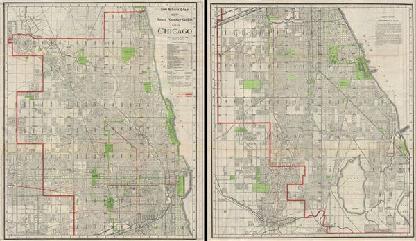
An uncommon 1910 map of Chicago, Illinois by Rand McNally and Company. The Rand McNally Company issued this enormous pocket map to illustrate their home city in incredible detail. The map is printed on two sides of a single sheet of paper. The top side, show above left, details northern Chicago from 33rd street northwards. This section of Chicago includes central Chicago, 'The Loop,' Lincoln Park, the beginnings of the Chicago Park System, and the Magnificent Mile. The southern side of the map, above right, details Chicago south of 33rd Street, including the southern tier of the Park System, Jackson Park (Field Museum), the Midway, Lake Calumet, and Wolf Lake.
Cartographer
Rand, McNally and Co. (fl. 1856 - present) is an American publisher of maps, atlases and globes. The company was founded in 1856 when William H. Rand, a native of Quincy, Massachusetts, opened a print shop in Chicago. Rand hired the recent Irish immigrant Andrew McNally to assist in the shop giving him a wage of 9 USD per week. The duo landed several important contracts, including the Tribune's (later renamed the Chicago Tribune) printing operation. In 1872, Rand McNally produced its first map, a railroad guide, using a new cost effective printing technique known as wax process engraving. As Chicago developed as a railway hub, the Rand firm, now incorporated as Rand McNally, began producing a wide array of railroad maps and guides. Over time, the firm expanded into atlases, globes, educational material, and general literature. By embracing the wax engraving process, Rand McNally was able to dominate the map and atlas market, pushing more traditional American lithographic publishers like Colton, Johnson, and Mitchell out of business. Eventually Rand McNally opened an annex office in New York City headed by Caleb S. Hammond, whose name is today synonymous with maps and atlases, and who later started his own map company, C. S. Hammond & Co. Both firms remain in business. More by this mapmaker...
Condition
Very good. Minor wear on original fold lines. Printed on both sides - images above represent both sides of a single sheet of paper.