This item has been sold, but you can get on the Waitlist to be notified if another example becomes available, or purchase a digital scan.
1890 Rand McNally Map or Plan of Chicago, Illinois
ChicagoStreet-randmcnally-1893$60.00

Title
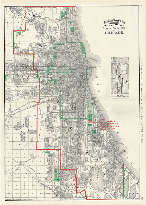
Street Guide Map of Chicago.
1890 (dated) 27 x 20 in (68.58 x 50.8 cm) 1 : 57000
1890 (dated) 27 x 20 in (68.58 x 50.8 cm) 1 : 57000
Description
A fine decorative map of Chicago issued in 1890 by Rand McNally and Company. This excellent map covers Chicago from Church Road in the north to Wolf Lane in the south, and from the suburb of Cicero and Lyons eastward to Lake Michigan. An inset map of the business portion of Chicago showing railroad depots in included along the right border.
Selected as a railway hub for most of the American Midwest, Chicago was undergoing a boom period and would soon draw the world's attention as the site for the 1893 Chicago World's Fair, or as it is better known, the Columbian exposition. The map identifies Jackson Park, the location selected for the fair. It also illustrates the Chicago Park System. The 'Park System,' designed by Olmsted prodigy William Le Baron Jenny in 1871, refers to a network of parks and garden boulevards intended to embrace the city in arms of foliage. Many of these parks and boulevards remain today.
This highly detailed map notes parks, piers, lakes, cemeteries, railroads, railway stations, and an assortment of other topographical details. Individual streets and buildings are identified. This map was issued as plate nos. 214 and 215 in the 1893 edition of Rand McNally and Company's Indexed Atlas of the World- possibly the finest atlas Rand McNally ever issued.
Cartographer
Rand, McNally and Co. (fl. 1856 - present) is an American publisher of maps, atlases and globes. The company was founded in 1856 when William H. Rand, a native of Quincy, Massachusetts, opened a print shop in Chicago. Rand hired the recent Irish immigrant Andrew McNally to assist in the shop giving him a wage of 9 USD per week. The duo landed several important contracts, including the Tribune's (later renamed the Chicago Tribune) printing operation. In 1872, Rand McNally produced its first map, a railroad guide, using a new cost effective printing technique known as wax process engraving. As Chicago developed as a railway hub, the Rand firm, now incorporated as Rand McNally, began producing a wide array of railroad maps and guides. Over time, the firm expanded into atlases, globes, educational material, and general literature. By embracing the wax engraving process, Rand McNally was able to dominate the map and atlas market, pushing more traditional American lithographic publishers like Colton, Johnson, and Mitchell out of business. Eventually Rand McNally opened an annex office in New York City headed by Caleb S. Hammond, whose name is today synonymous with maps and atlases, and who later started his own map company, C. S. Hammond & Co. Both firms remain in business. More by this mapmaker...
Source
Rand McNally & Co., Rand, McNally & Co's Indexed Atlas of the World, (Chicago) 1893.
Condition
Very good. Original centerfold exhibits minor wear. Text on verso.
References
Rumsey 3565.111 (1897 edition).