This item has been sold, but you can get on the Waitlist to be notified if another example becomes available, or purchase a digital scan.
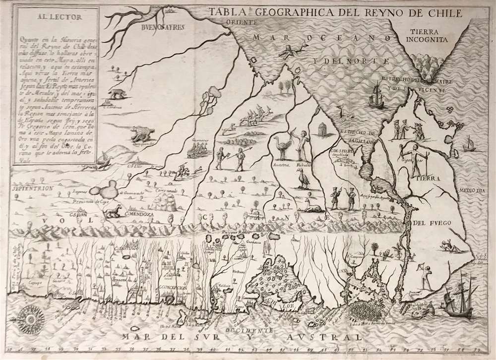
1728 Ovalle Map of Chile and Patagonia
Chile-ovalle-1728$4,250.00

Title
Tabla Geographica del Reyno de Chile.
1728 (undated) 12 x 17.25 in (30.48 x 43.815 cm) 1 : 8400000
1728 (undated) 12 x 17.25 in (30.48 x 43.815 cm) 1 : 8400000
Description
This is an extremely rare Spanish edition of Alonso de Ovalle's map of Chile - arguably the most important early map of Chile, as it is the first printed map of the region produced by someone who actually lived there. it was published to illustrate Ovalle's Historia relacion del Reyno de Chile, the first history of that country. This Spanish edition of the map is significantly rarer than the Italian edition of the same year - we see no separate examples of the map in institutional collections.
Richly Detailed
In detail, the map far surpasses any other map of Chile produced contemporaneously or prior. Its scope is broad: it extends from the Atlantic to the Pacific, and includes Tierra del Fuego as well as Drake's Island south of Cape Horn. It is rich in place names, and shows mines, missions, cities, towns volcanoes and rivers. It marks the course of the River Bio Bio as the boundary between Spanish and Araucanian territory (sharply relevant for Ovalle's history, which dwelt on the Araucanian wars.) Lawrence Wroth in Imago Mundi (vol 14) hailed the map as 'one of the most informative American maps of its period.'Visually Engaging
The map is beautifully engraved, accompanying the detailed geographical information with animals, native figures (with and without tails!) and an evocative pictorial presentations of the volcanic mountains along the Pacific Coast. The oceans are sailed by ships, prowled by monsters, and embellished with a fine compass rose.Publication History and Census
This map is rare. There are no copies of this separate map in OCLC, and only a handful of copies have come on the market.Cartographer
Alonso de Ovalle Pastene (July 27, 1603 - May 11, 1651) was a Chilean born historian, educator and Jesuit, known for producing Historia relacion del Reyno de Chile, the first history of Chile. He was born in Santiago, Chile, son of Francisco Rodríguez del Manzano Ovalle and María Pastene Lantadilla Astudillo. Alonso lived and worked for most of his life in Chile, but resided in Rome from 1642 to 1650, where he had his work published. It included arguably the most important early map of Chile, the first printed map of the region produced by someone who actually lived there. He returned to South America, dying in Lima in 1651. More by this mapmaker...
Source
Ovalle, Alonso Historica relacion del Reyno de Chile y de las missiones y ministerios que exercita en el la Compañía de Jesus Spain, 1728
Condition
Very good condition. Few faint stains and one mend, else excellent.
References
No copies in OCLC.