1908 Lagos / Simonetti Map of Franciscan Missions in Chile
ChileMissions-lagos-1908$950.00


Title
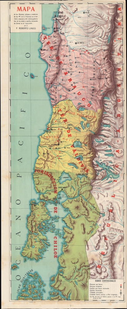
Mapa de las misiones antiguas y modernas de los de los PP. de San Francisco en el territorio araucano y del sistema gubernativo de los indios y capillas misionales de Chiloé en el siglo XVIII.
1908 (undated) 35.5 x 13.75 in (90.17 x 34.925 cm) 1 : 975000
1908 (undated) 35.5 x 13.75 in (90.17 x 34.925 cm) 1 : 975000
Description
A 1908 map of Chile, reflecting the vertical geography of the country, drawn by U. Simonetti for Roberto Lagos' book Historia de las Misiones del Colegio de Chillán. It details the locations of Franciscan missions in the Araucanía region in the 18th century when the missionaries acted as intermediaries between an encroaching Spanish colonial system and recalcitrant indigenous peoples.
A Closer Look
Covering a region stretching from Chillán to the Chiloé islands and inland to the Andes and the modern-day border with Argentina, the map color-shades Spanish colonial territories while also indicating dominant local indigenous groups of the 18th century, all of which fall under the wider category of Mapuche. Unsurprisingly, groups closer to the heart of Spanish rule further north, such as the Picunche, were by the 18th century more integrated with Spanish culture and rule, with a large mestizo population becoming predominant over time, while groups further to the south retained more of their indigenous culture and religion. Former and current (that is, 1908) Franciscan missions and chapels are noted throughout, along with cities, settlements, and geographic features. The Franciscans were especially active in the islands of Chiloé, having established several dozen missions and chapels in the 18th century.Historical Context
When Spanish conquistadors set out to conquer the Araucanía region in central Chile, the indigenous Mapuche people (an umbrella term for several related groups) successfully resisted, beginning an intermittent conflict that would last nearly 300 years (the Mapuche already had a deserved reputation for fierceness, fighting off Inca encroachments on their land). Although Spain had gained nominal control over Araucanía, for much of the colonial period, the region served as a buffer region between the Spanish and Mapuche, though Spain did establish several tenuous forts and settlements (there were three major uprisings and several other attempted uprisings and local incidents in the 19th century). Catholic missionaries arrived soon after the conquistadors and were somewhat more welcomed by Mapuche. Nonetheless, there were differences by locality, time period, and the religious order (the Jesuits were flexible on matters of doctrine, the Franciscans and Dominicans less so). Although they made limited headway in terms of conversion, the Franciscans pushed for reforms to Spanish colonial administration, such as the methods of the Indian labor system (slavery). Mapuche resistance to outside rule in Araucanía continued through the Chilean War of Independence and until the forcible 'pacification' of the region in the 1860s - 1880s, followed by an even more extreme effort against the Mapuche in Patagonia, which has been labeled by some historians as a genocide.Publication History and Census
This map was drawn by U. Simonetti (about whom we can find no information), printed by Impresa generale di affissioni e pubblicità in Rome, and prepared by Roberto Lagos and appeared in his 1908 book Historia de las Misiones del Colegio de Chillán. Though Lagos' entire book (OCLC 24598006) is well-represented in institutional collections, the map is not independently cataloged in the OCLC and is scarce to the market.Cartographer
Roberto Lagos Baeza (1860 - 1928) was a Franciscan missionary, historian, and archivist. He spent much of his career organizing and cataloging the archives of the Franciscan provinces in Chile, namely the 'colleges' of Chillán and Castro, resulting in 88 volumes of archival material. In the process, Lagos undertook research for his encyclopedia 1908 work Historia de las Misiones del Colegio de Chillán. More by this mapmaker...
Condition
Very good. Light wear along original folds. Light soiling.
References
OCLC 24598006.