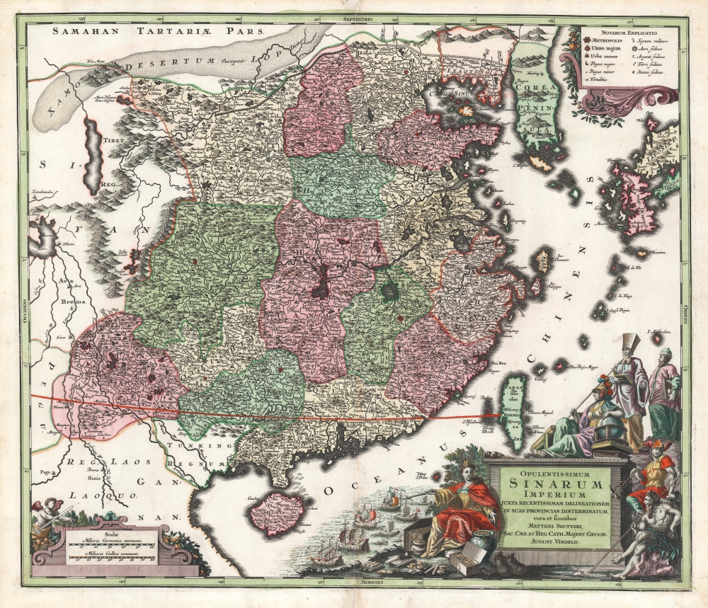
1736 Seutter Map of China and Korea
China-seutter-1736$1,500.00

Title
Opulentissimum Sinarum imperium juxta recentissimam delineationem in suas provincias disterminatum, cura et sumtibus Matthaei Seutteri, Sac. Caes. et Reg. Cath. Majest. Geogr. August. Vindelic.
1736 (undated) 19.5 x 22.5 in (49.53 x 57.15 cm) 1 : 150000
1736 (undated) 19.5 x 22.5 in (49.53 x 57.15 cm) 1 : 150000
Description
A striking example of Matthias Seutter's 1732 map of China and Korea, also showing Formosa (Taiwan), and western Japan. It is considered one of the more attractive maps of China to appear in Europe in the first half of the 18th century.
A Closer Look
The map is ultimately derived from the Jansson / Van Loon map of China, possibly through the intermediary of the Schenk imprint of that earlier map. Seutter's map differs from the Van Loon most dramatically in its inclusion of the western part of the Japanese Islands, which are excluded from its precursor. The map also extends further south than the Van Loon, affording a view of the Lancang river (the upper reaches of the Mekong) reaching into upper Laos.An Evocative, Exotic Cartouche
Apart from the above inclusions, the main benefit of the increased scope of the map is to allow more space in the Oceanus Chinensis for the map's massive, grand cartouche. The map's title (and those of Seutter himself) are inscribed on a great plinth. Classical figures gaze upon the map spread before them: these represent a Chinese official and a Jesuit scholar, both are in the company of Athena (wisdom and war), Mercury (commerce and wealth), and Neptune (the sea). On the other side of the cartouche, Europa - resplendent in silks - faces the reader and gestures both at the treasures piled about her feet, and the fleet of ships that brought them.Publication History and Census
This map was engraved as early as 1732 by Matthias Seutter for inclusion in his several atlases. Although undated, it can have been issued no earlier, as it bears his title of Imperial Geographer. The map does not include Seutter's Privilegio, which was added to editions in and after 1740. We see nineteen examples of this map in institutional collections.Cartographer
Matthäus Seutter (1678 - 1757) was one of the most important and prolific German map publishers of the 18th century. Seutter was born the son of a goldsmith but apprenticed as a brewer. Apparently uninspired by the beer business, Seutter abandoned his apprenticeship and moved to Nuremberg where he apprenticed as an engraver under the tutelage of the prominent J. B. Homann. Sometime in the early 1700s Seutter left Homann to return to Augsburg, where he worked for the prominent art publisher Jeremiad Wolff (1663 - 1724), for whom he engraved maps and other prints. Sometime around 1717 he established his own independent cartographic publishing firm in Augsburg. Though he struggled in the early years of his independence, Seutter's engraving skill and commitment to diversified map production eventually attracted a substantial following. Most of Seutter's maps are heavily based upon, if not copies of, earlier work done by the Homann and De L'Isle firms. Nonetheless, by 1731/32 Seutter was one of the most prolific publishers of his time and was honored by the German Emperor Karl VI who gave him the title of Imperial Geographer, after which most subsequent maps included the Avec Privilege designation. Seutter continued to publish until his death, at the height of his career, in 1757. Seutter had two engraver sons, Georg Matthäus Seutter (1710 - 173?) and Albrecht Carl Seutter (1722 - 1762). Georg Matthäus quit the business and relocated to Woehrdt in 1729 (and probably died shortly thereafter), leaving the family inheritance to his wastrel brother Albrecht Carl Seutter, who did little to advance the firm until in own death in 1762. Following Albrecht's death, the firm was divided between the established Johann Michael Probst (1727 - 1776) firm and the emerging firm of Tobias Conrad Lotter. Lotter, Matthäus Seutter's son-in-law, was a master engraver and worked tirelessly on behalf of the Suetter firm. It is Lotter, who would eventually become one of the most prominent cartographers of his day, and his descendants, who are generally regarded as the true successors to Matthäus Seutter. (Ritter, M. Seutter, Probst and Lotter: An Eighteenth-Century Map Publishing House in Germany., "Imago Mundi", Vol. 53, (2001), pp. 130-135.) More by this mapmaker...
Source
Seutter, M., Grosser Atlas, (Augsburg) c. 1730.
Condition
Very good. Small marginal mend not impacting image. Original color, refreshed.
References
OCLC 159823404.