This item has been sold, but you can get on the Waitlist to be notified if another example becomes available, or purchase a digital scan.
1851 Black Map of China
China2-black-1851$75.00

Title
China.
1851 (undated) 12.5 x 16.5 in (31.75 x 41.91 cm) 1 : 8550000
1851 (undated) 12.5 x 16.5 in (31.75 x 41.91 cm) 1 : 8550000
Description
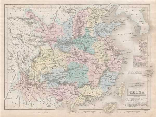
This is an 1851 Adam and Charles Black map of China. The map depicts China from Chinese Tartary to Hainan and from Assam in India to Korea (Corea), inclusive of Formosa or Taiwan. Four inset maps detail Amoy, Hong Kong, ZhouShan and Hainan. The Great Wall of China is identified. Taiwan or Formosa is mapped vaguely, representing the poor knowledge of the region prior to the Japanese invasion and subsequent survey work in 1895. Both Hong Kong and Macao are identified.
At this point in history, this region was dominated by China's last Imperial Dynasty, the Qing. As this map went to press, in 1851, the region was about to dissolve into one of the bloodiest wars in human history, the Taiping Rebellion against the Qing, which lasted from 1851 until 1862 and cost more than 20 million lives. Around the same time, the Second Opium War or the Arrow War, a conflagration which lasted from 1856 until 1860, resulted in the concession of Tientsin and Hong Kong by the Chinese to the British.
Myriad cities, towns, rivers, mountain passes and an assortment of additional topographical details are identified throughout. Provinces are color coded, allowing for easy differentiation. This map was engraved by W. Hughes and issued as plate no. 55 in the 1851 edition of Black's General Atlas.
Cartographer
Charles and Adam Black (fl. 1807 - present) were map and book publishers based in Edinburgh. Charles and his uncle, Adam, both of Edinburgh, Scotland, founded their publishing firm in 1807. They published a series of maps and atlases throughout the 19th century. In addition to an array of atlases, the Black firm is known for their editions of the Encyclopedia Britannica (1817 - 1826) and the first publishing of Sir Walter Scott's novels in 1854. In 1889 the A. & C. Black publishing house moved to London where it remains in operation to this day. More by this mapmaker...
Source
Black, A. and C., General Atlas Of The World, (Edinburgh) 1851.
Condition
Very good. Blank on verso. Original platemark visible.
References
Rumsey 2305.065 (1854 edition). Philips (atlases) 4334.