1738 Emanuel Bowen Map of China and Korea
ChinaKorea-bowenanville-1738$3,500.00

Title
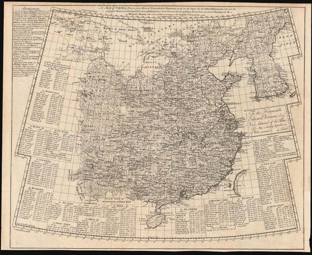
A Map of China, drawn from those of the particular provinces made on the spot by the Jesuit missionaries...
1738 (undated) 18.25 x 22 in (46.355 x 55.88 cm) 1 : 7500000
1738 (undated) 18.25 x 22 in (46.355 x 55.88 cm) 1 : 7500000
Description
This is Emanuel Bowen's rare 1738 map of China and Korea, derived from the geography of Jean Baptiste Bourguignon d'Anville. It is not a direct copy of D'Anville's maps but rather is a distillation of Chinese provincial maps included in Du Halde's 1737 Nouvel atlas de la Chine, which Bowen reproduced in the 1738 English edition of that work. Via D'Anville, this is one of the best 18th-century maps of China originating from Chinese sources.
Roots in the Kanxi Atlas
D'Anville's maps were themselves extremely faithful copies of the maps found in the 'Jesuit Atlas' or the 'Kangxi Atlas,' produced between 1708 and 1718 on behalf of the Qing Emperor with the assistance of French Jesuits. The atlas, Huangyu Quanlan Tu / 皇輿全覽圖 [Overview Maps of the Imperial Territories], was never available for public sale but had been produced in three printed editions in China for official consultation. It is supposed that French Jesuit Pierre Jartoux (1669 - 1720) managed to secret a copy to Paris, where it was given to Du Halde for 1735 publication in France. It contained a general map of China and Korea, a general map of China alone, thirty-nine regional maps of Chinese provinces, and a further map showing Bering's explorations of the Asian north. In short order, an English edition was published by Edward Cave in 1738, its maps engraved by Emanuel Bowen. While the provincial maps are close copies of D'Anville's, the general maps produced by Bowen did not duplicate those of the French edition. In terms of their projection and their scope, they are unique works. Cave's translation of Du Halde was produced in a single edition, with the result that its maps - particularly this one - are rare.A Closer Look
Bowen's map covers the Qing Empire and Joseon Korea, from Hainan Island in the south to the Gobi Desert in the north. The western limits reach Burma (Pegu) and the modern Bayingolin Mongol Autonomous Prefecture. To the east, Taiwan is shown with an undefined east coast. The map's eastern limit includes parts of the Sea of Japan and what is now part of the Russian Federation. Japan is not included. Bowen's work includes considerably more detail than the D'Anville general maps, drawing heavily on the provincial maps. The strictures of scale prevent the inclusion of many placenames, particularly in the Korean peninsula, where numerous towns are marked but unnamed. The difficulty of including legible placenames is somewhat ameliorated by the inclusion of fifteen tables providing the 'Principal Latitudes observed and Longitudes determined geometrically whereon this Map is grounded'. The map includes explanations of the conventions of English orthography used in the transliterations of Chinese names. A brief description of the Chinese/Jesuit efforts in surveying the country is also included.Publication History and Census
This map was composed and engraved by Emanuel Bowen in 1737 for inclusion in Edward Cave's 1738 A Description of the Empire of China. There is one recorded state of the map, the book having been published in a single edition. We are aware of a single institutional copy of the separate map in the collection of the National Library of Australia, and the map is scarce on the market.CartographerS
Jean Baptiste Bourguignon d'Anville (1697 - 1782) was perhaps the most important and prolific cartographer of the 18th century. D'Anville's passion for cartography manifested during his school years when he amused himself by composing maps for Latin texts. There is a preserved manuscript dating to 1712, Graecia Vetus, which may be his earliest surviving map - he was only 15 when he drew it. He would retain an interest in the cartography of antiquity throughout his long career and published numerous atlases to focusing on the ancient world. At twenty-two D'Anville, sponsored by the Duke of Orleans, was appointed Geographer to the King of France. As both a cartographer and a geographer, he instituted a reform in the general practice of cartography. Unlike most period cartographers, D'Anville did not rely exclusively on earlier maps to inform his work, rather he based his maps on intense study and research. His maps were thus the most accurate and comprehensive of his period - truly the first modern maps. Thomas Basset and Philip Porter write: "It was because of D'Anville's resolve to depict only those features which could be proven to be true that his maps are often said to represent a scientific reformation in cartography." (The Journal of African History, Vol. 32, No. 3 (1991), pp. 367-413). In 1754, when D'Anville turned 57 and had reached the height of his career, he was elected to the Academie des Inscriptions. Later, at 76, following the death of Philippe Buache, D'Anville was appointed to both of the coveted positions Buache held: Premier Geographe du Roi, and Adjoint-Geographer of the Academie des Sciences. During his long career D'Anville published some 211 maps as well as 78 treatises on geography. D'Anville's vast reference library, consisting of over 9000 volumes, was acquired by the French government in 1779 and became the basis of the Depot Geographique - though D'Anville retained physical possession his death in 1782. Remarkably almost all of D'Anville's maps were produced by his own hand. His published maps, most of which were engraved by Guillaume de la Haye, are known to be near exact reproductions of D'Anville' manuscripts. The borders as well as the decorative cartouche work present on many of his maps were produced by his brother Hubert-Francois Bourguignon Gravelot. The work of D'Anville thus marked a transitional point in the history of cartography and opened the way to the maps of English cartographers Cary, Thomson and Pinkerton in the early 19th century. More by this mapmaker...
Emanuel Bowen (1694 - May 8, 1767) had the high distinction to be named Royal Mapmaker to both to King George II of England and Louis XV of France. Bowen was born in Talley, Carmarthen, Wales, to a distinguished but not noble family. He apprenticed to Charles Price, Merchant Taylor, from 1709. He was admitted to the Merchant Taylors Livery Company on October 3, 1716, but had been active in London from about 1714. A early as 1726 he was noted as one of the leading London engravers. Bowen is highly regarded for producing some of the largest, most detailed, most accurate and most attractive maps of his era. He is known to have worked with most British cartographic figures of the period including Herman Moll and John Owen. Among his multiple apprentices, the most notable were Thomas Kitchin, Thomas Jeffreys, and John Lodge. Another apprentice, John Oakman (1748 - 1793) who had an affair with and eventually married, Bowen's daughter. Other Bowen apprentices include Thomas Buss, John Pryer, Samuel Lyne, his son Thomas Bowen, and William Fowler. Despite achieving peer respect, renown, and royal patronage, Bowen, like many cartographers, died in poverty. Upon Emanuel Bowen's death, his cartographic work was taken over by his son, Thomas Bowen (1733 - 1790) who also died in poverty. Learn More...
Source
D'Anville, Jean Baptiste Bourguignon, A description of the Empire of China, (London: Gardner) 1738.
Condition
Very good. Margin reinstated at insertion point. Else excellent.
References
OCLC 965614664.