This item has been sold, but you can get on the Waitlist to be notified if another example becomes available, or purchase a digital scan.
1832 Lapie Map of the Chinese Empire, Korea, and Japan
Chinois-lapie-1829$112.50

Title
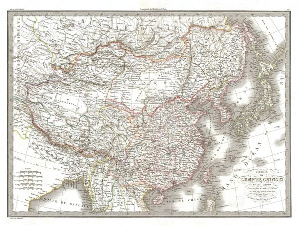
Carte de l'Empire Chinois et du Japon.
1832 (dated) 16.5 x 22 in (41.91 x 55.88 cm)
1832 (dated) 16.5 x 22 in (41.91 x 55.88 cm)
Description
A fine first edition example of M. Lapie's 1832 map of the Chinese empire and Japan. The map covers all of China, Korea, and Japan from Asiatic Russia to India and the Sea of China and from Independent Tartary to the Pacific Ocean, just a few years prior to the Opium Wars. As this map was printed, the weakening Qing, China's last imperial dynasty, dominated the region. Following the Napoleonic Wars of 1815, trade between China and europe increased dramatically, leading to hostility between the Qing regime and the european governments. Increased demand for Chinese goods in europe and a distinct lack of interest in european goods in China led to a trade imbalance that began to deplete european raw materials. european merchants consequently introduced opium to china, ultimately leading to the Opium Wars of 1839.
This map is also exceptionally interesting for its treatment of the Sea of Korea (Mer de Corea) and the Sea of Japan (Mer de Japon). Today both names are used to refer to the body of water between Korea and Japan. There is considerable academic dispute between the two nations over the proper name. Lapie curiously uses both names, defining the sea between Korea and Japan as the Sea of Japan and the sea between Korea and Taiwan (Formosa) as the Sea of Korea.
This map was engraved by Armand Joseph Lallemand as plate no. 36 in the first edition of M. Lapie's important Atlas Universel. This map, like all maps from the Atlas Universel features an embossed stamp from the Lapie firm.
CartographerS
Pierre M. Lapie (fl. 1779 - 1850) and his son Alexandre Emile Lapie (fl. 1809 - 1850) were French cartographers and engravers active in the early part of the 19th century. The Lapies were commissioned officers in the French army holding the ranks of Colonel and Capitan, respectively. Alexander enjoyed the title of "First Geographer to the King", and this title appears on several of his atlases. Both father and son were exceptional engravers and fastidious cartographers. Working separately and jointly they published four important atlases, an 1811 Atlas of the French Empire (Alexander), the 1812 Atlas Classique et Universel (Pierre), the Atlas Universel de Geographie Ancienne et Modern (joint issue), and the 1848 Atlas Militaire (Alexander). They also issued many smaller maps and independent issues. All of these are products of exceptional beauty and detail. Despite producing many beautiful maps and atlases, the work of the Lapie family remains largely underappreciated by most modern collectors and map historians. The later 19th century cartographer A. H. Dufour claimed to be a student of Lapie, though it is unclear if he was referring to the father or the son. The work of the Lapie firm, with its precise engraving and informational density, strongly influenced the mid-19th century German commercial map publishers whose maps would eventually dominate the continental market. More by this mapmaker...
Armand Joseph Lallemand (c. 1810 - 1871) was an engraver and map publisher based in Paris during the mid-19th century. Most of Lallemand's work focused on landscapes and building vies, though he did take part in a few cartographic ventures, including the production of an atlas with Alexandre Emile Lapie and several tourist pocket maps of Paris. Learn More...
Source
Lapie, M., Atlas Universel de Geographie. Ancienne et Moderne, precede d'un Abrege de Geographic Physique et Historique…, 1829. (Rumsey identifies this as the first edition of Lapie's Atlas Universel. In all known examples, the title page is dated 1829 while the maps are dated variously to 1833 - suggesting that the first issue of this atlas was 1833, not 1829.)
Condition
Very good. Original platemark visible. Blank on verso. Original centerfold.
References
Rumsey 2174.036. Phillips (Atlases) 754, 765.