1881 Urban Planning Map of Cienfuegos, Cuba
CienfuegosCuba-unknown-1881$650.00

Title
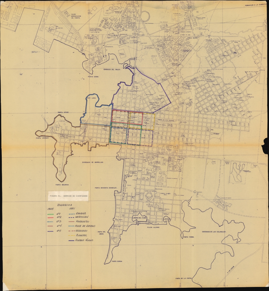
Figura 31. Barrios de Cienfuegos.
1881 (dated) 25.5 x 23.75 in (64.77 x 60.325 cm)
1881 (dated) 25.5 x 23.75 in (64.77 x 60.325 cm)
Description
This is an 1881 diazo neighborhood map of Cienfuegos, Cuba, once called 'La Perla del Sur' and cited by UNESCO as the best extant example of early 19th-century Spanish Enlightenment urban planning. The map depicts the peak of the city's urban expansion in the late 19th century, in the wake of the Guerra de los Diez Años (1868 - 1878).
A Closer Look
The map compares the 'barrios' of Cienfuegos in 1845 and 1881, highlighting changes in hand-colored manuscript. Planned expansions are evident throughout, including new roads, industrial zones, and residential neighborhoods are ghosted in. Even the city cemetery is scheduled for significant expansion. The map's medium, a diazo or white print, indicates that it represents an extremely small-run architectural and civil engineering plans, making it clear that this map was never intended for commercial distribution.Cienfuegos
Cienfuegos was founded in 1819 by French settlers under the Spanish crown. The city quickly became a hub for sugar and coffee plantations, driving its economic growth. Cienfuegos' architecture and urban planning, influenced by its French origins, displayed a unique blend of European and Caribbean styles, setting it apart from other Cuban cities. The city's architecture took on a neoclassical style in the late 19th century, reflecting its economic prosperity. The natural deep-water bay facilitated thriving maritime trade, further enhancing its economic significance. The latter part of the century saw Cienfuegos engulfed in the struggles for Cuban independence, marked by political upheavals and conflicts such as the Guerra de los Diez Años (1868 - 1878) and the Spanish-American War (1898). Today, Cienfeugos has become one of Cuba's leading industrial centers. Despite the challenges of a repressive communist regime, including economic and political constraints, Cienfuegos continues to thrive as a unique blend of historical legacy and Cuban modernity.Diazo Print or Whiteprint
The diazo print (whiteprint or diazo for short) is a photo reproductive technique best understood as a reverse cyanotype or blueprint. The process yields distinctive blue lines on white paper. Like cyanotypes, the diazo process gained popularity in architecture circles, where it was a simple and effective way to duplicate documents in the field. The earliest diazotypes appeared around 1880 and were adopted for military and field cartographic use from about 1895. The diazo process was commercialized in 1923, when the German firm, Kalle and Company, developed Ozalid, a patented diazo paper that made diazotyping even easier. By the 1950s, it supplemented cyanotypes as the reprographic technique of choice for technical drawings.Publication History and Census
This is the only known surviving example of this important urban planning map.Condition
Average. Overall toning, especially on old fold lines. Edge loss, right center.