This item has been sold, but you can get on the Waitlist to be notified if another example becomes available, or purchase a digital scan.
1877 Gray Map of Cincinnati
Cincinati-gray-1877$75.00

Title
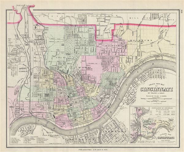
Gray's New Map of Cincinnati.
1877 (dated) 12.5 x 15 in (31.75 x 38.1 cm) 1 : 24000
1877 (dated) 12.5 x 15 in (31.75 x 38.1 cm) 1 : 24000
Description
A fine 1877 map of Cincinnati, Ohio by O. W. Gray and Sons. It covers the city from Fairmount to Columbia south across the Ohio River to Covington in Kentucky. The map is extremely detailed, showing individual buildings, major and minor streets, railroads, cemeteries, parks, and several other landmarks. Various topographical features are also included. A reference key in included in the bottom left quadrant. An inset featuring the outline map of Cincinnati is included in the lower right quadrant. This map is copyrighted and issued by O.W. Gray and Sons, Philadelphia in 1877.
Cartographer
Ormando Wyllis Gray (March 3, 1829 – July 6, 1912) was a mid to late 19th century map publisher with offices in New York City, Philadelphia, PA, and Danielsonville, Connecticut. Born in Townshend, Vermont, he attended Norwich College where he studied civil engineering and became a civil engineer and surveyor. Gray's first commercial atlas was an 1869 survey of Windhamd and Toland counties, Connecticut. His most important work seems to have been done in conjunction with other, more prominent map publishers, including Henry Walling and G.W. and C.B. Colton. Gray is best known for his state and county atlases, though did, with his sons, also independently issue at least two national atlases in the late 1870s. He retired from the map publishing business in 1890. He died at home in Bernardston, Massachusetts. He married Roxcena L. Arnold in 1851, with whom he had three daughters and one son. More by this mapmaker...
Condition
Very good. Partial map on verso.