This item has been sold, but you can get on the Waitlist to be notified if another example becomes available, or purchase a digital scan.
1875 Kenny Map of Cincinnati, Ohio
CincinnatiSuburbs-kenny-1875$137.50

Title
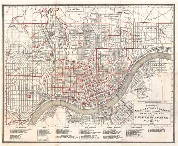
New Map of Cincinnati and Suburbs.
1875 (dated) 15 x 18.5 in (38.1 x 46.99 cm) 1 : 25000
1875 (dated) 15 x 18.5 in (38.1 x 46.99 cm) 1 : 25000
Description
This is an 1875 D.J. Kenny map of Cincinnati, Ohio and its suburbs. The map is oriented to the north, with the Ohio River dominated the lower portion of the map, acting as the border between Ohio and Kentucky. The map is incredibly detailed, labeling streets, utilities, railroads, and other parts of the city. At the bottom of the map, a list of 55 points of interest is included, which lists the rail road depots, hotels, theaters, parks, gardens, libraries, hospitals, public and private institutions, as well as charities. John A. Roebling's suspension bridge is also labeled on the map (suspension bridge), which was opened in 1866, and spans the Ohio River between Cincinnati, Ohio and Covington, Kentucky. John A. Roebling was also the architect of the Brooklyn Bridge and the similarity between the two bridges is significant. A pattern of half-mile wide concentric circles is overlaid on the map, centered on downtown Cincinnati. The city wards are also numbered. This is a wonderful map of Cincinnati and would make a great addition to any collection. This map was prepared expressly by Strobridge and Co. for Illustrated Cincinnati by D.J. Kenny.
Source
Kenny, D., Illustrated Cincinnati (Cincinnati: R. Clarke), 1875.
Condition
Very good. Backed on archival tissue. Some wear and toning on original fold lines.
References
OCLC 69914479.