
1971 Smedley Map of Citrus County, Florida

This item has been sold.
Smedley's Road and Sectional Map Citrus County Florida.
From Citrus Trees to a Commuter Community.
From Citrus Trees to a Commuter Community.
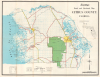
This is an unrecorded 1971 J. M. Smedley sectional map of Citrus County, Florida. It depicts the county at a time when it was growing rapidly, changing from a sparsely populated rural area to an exurban community for nearby cities, particularly Tampa.A Closer Look
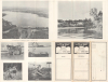
This colorful map covers the entire county with survey lines while also tracing highways and major roads, indicating towns, and noting waterways and state park/forest land. Islands, keys, and bays are also recorded along the coast. Photographs of the county's landscape and wildlife appear on the verso. The county's name comes from its once-thriving citrus industry, though it is no longer a major producer of citrus, having never recovered from the 'Great Freeze' of 1894 - 1895.The Florida Cross-State Canal
At top-left, the Florida Cross-State Canal is indicated. This long-discussed and ambitious project was never completed, despite gaining significant headwinds in the 1940s - 1960s. Environmental concerns led to lawsuits that challenged the project, and in 1971, the same year as this map's publication, President Richard Nixon signed an executive order halting the project. Afterward, the federal government transferred ownership of the lands along the intended canal route to the State of Florida, which designated it the Cross Florida Greenway State Recreation and Conservation Area, renamed in 1998 after Marjorie Harris Carr, the conservationist who led opposition to the canal.Citrus County
Located some 65 miles north of Tampa and a similar distance to the west of Orlando (when measured from the county seat of Inverness), Citrus County has seen significant growth in recent decades as suburbs of both cities have expanded outwards. Although still rather rural or exurban today, the population of the county increased from less than 10,000 in 1960 to nearly 120,000 in 2000 and has continued to grow since, to over 150,000 today. This growth was greatly aided by the construction of highways, including Interstate-71, which does not traverse Citrus County but runs to its east along a route roughly parallel to U.S. Route 41, at right here.Publication History and Census
This map was prepared by the map publishing firm J. M. Smedley in 1971. It is not recorded among the holdings of any institution. A handful of Smedley maps of other Florida counties are held in institutional collections, such as a 1970 map of Seminole County at the Tampa Bay History Center's Touchton Map Library.Cartographer
Joseph Melton Smedley, Sr. (June 7, 1902 - July 12, 1973) was a Florida-based atlas and map publisher active in the Postwar period. Smedley was born in Florida and spent most of his life in his home state, though the full details of his biography are difficult to discern. The 1930 Federal Census shows him and his wife Mina living in Atlanta, Georgia, while his World War II draft card places him in Columbia, South Carolina working at a radio station. Spotty records list him as a wage worker or traveling salesman, but in the Postwar period, Smedley and his family settled in Daytona Beach, Florida. He maintained a business in DeLand, which issued a variety of city and county maps, plat maps, and land ownership atlases of cities and counties throughout Florida. Although his firm's output ranges from c. 1954 - 1971, it was most active in the mid-late 1960s. Further Details...
Condition
Very good. Slight wear on old fold lines.
References
cf. Tampa Bay History Center, Touchton Map Library, #2017.062.012.