
1939 Taylor Pictorial View of Treasure Island, San Francisco (Golden Gate Int'l Expo)

This item has been sold.
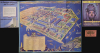
A Cartograph of Treasure Island in San Francisco Bay Golden Gate International Exposition.
'Pageant' on the Eve of the WWII.
'Pageant' on the Eve of the WWII.
This is Ruth Taylor's colorful 1939 pictorial view of Treasure Island in San Francisco Bay, site of the 1939-1940 Golden Gate International Exposition. An extravaganza of Art Deco glamour and a celebration of diverse cultures, the Exposition nevertheless signaled an ephemeral era of optimistic cosmopolitanism before the global descent into World War II (1939-1945).A Closer Look
The northeast-oriented view illustrates the grounds of the Golden Gate International Exposition, including part of San Francisco in the foreground. Illustrations of airplanes, whales, boats, and other whimsical sea animals appear in the water around Treasure Island. A key in the lower left locates buildings, statues, courts, and pavilions. The verso includes an index and detailed plans of routes and group areas.The Golden Gate International Exposition
The Golden Gate International Exposition was a World's Fair held to celebrate the two new bridges of San Francisco - the San Francisco-Oakland Bay Bridge and the Golden Gate Bridge - both completed in the preceding decade. The Exposition featured, among other attractions, the Tower of the Sun (seen here in the center of the view) and a giant statue of 'Pacifica,' the goddess of the Pacific Ocean, highlighting the exposition theme, 'Pageant of the Pacific' (see our PageantPacificSet-covarrubias-1943). Many other sensational, elaborate attractions can be seen here, including the pyramidical 'Portals of the Pacific' and the 'Gayway' amusement avenue, complete with sideshows, a racetrack featuring monkeys driving automobiles, and 'Sally Rand's NDude Ranch,' starring the famous burlesque dancer.During the radio broadcast of the opening ceremony, President Franklin D. Roosevelt said:
Washington is remote from the Pacific. San Francisco stands at the doorway to the sea that roars upon the shores of all these nations, and so to the Golden Gate International Exposition I gladly entrust a solemn duty. May this, America's World's Fair on the Pacific in 1939, truly serve all nations in symbolizing their destinies, one with every other, through the ages to come.Roosevelt was personally invested in the success of the Exposition. Preparations for the event were a massive undertaking that combined local initiative with significant New Deal support. The Exposition required the creation of an entirely new, man-made island on the Yerba Buena shoals, adjacent to Yerba Buena Island (Goat Island), resulting in a low, flat, rectangular-shaped landmass that stands in stark contrast to the hilly landscape of the Bay Area. Much of the heavy construction work - land reclamation, utilities, roads, and building foundations - was carried out under the Works Progress Administration (WPA). Federal funding supplemented state and municipal contributions, allowing for the development of the island's airport facilities, fairgrounds, and monumental art-deco-inspired architecture.
Although the event was well-attended and acclaimed, it did not herald the hoped-for era of Transpacific brotherhood. Instead, like the contemporaneous World's Fair in New York City, it ominously coincided with the outbreak of World War II (1939 - 1945) in Europe. Little more than a year after the Exposition's conclusion, Japan and the United States, the two major powers in the Pacific, were at war. The San Francisco Bay, which already had a significant military presence, became one of the primary hubs of U.S. military production and organization, with Treasure Island itself being turned into a naval base in 1941.
Publication History and Census
This view was created by Ruth Taylor White. It is accompanied by an entry ticket and is bound into the Exposition's Official Guide Book, which includes advertisements, pictures, and important information about the Exposition. The map is cataloged among the holdings of the University of California Berkeley, the University of California Los Angeles, the University of North Texas, the University of Wisconsin Milwaukee, and Yale University, while the entire guidebook (published in at least three editions - two in 1939 and one in 1940) is more widely distributed.Cartographer
Ruth D. Taylor White (March 1896 - 20??), a.k.a. Ruth Taylor Day, was an American pictorial mapmaker, what she liked to call 'carto-graphy'. Ruth was born Oregon to the painter John S. Taylor (1858 - 1927). Her interest in cartographic mapmaking was probably inspired by her sister Della Taylor Hoss (1900 - 1997), also an important pictorial cartographer. One of her first published works was a cover of The Stanford Illustrated Review, where her brother Frank attended university. Frank was an accomplished journalist and writer, and Ruth provided the illustrations for two of his books, popular works about the national parks, ’Oh Ranger!’ A Book About the National Parks and Grand Canyon Country. In the spring of 1930, White traveled to Hawaii, where she received a commission from the Hawaii Tourist Bureau to create pictorial maps of the Hawaiian Islands. Sets of five maps began appearing in 1931, with maps of Kauai, Oahu, Maui, Hawaii, and the island chain as part of the set. These were most likely handed out to visitors by the Bureau. White’s most famous work, a pictorial atlas entitled, Our USA: A Gay Geography was published in 1935 and was filled with ‘cartography’ of each state, which she published with her brother as Ruth Taylor. White is also known for her map of Treasure Island, the site of the Golden Gate International Exposition. A third sister, Bernice Taylor Fitzgerald, was also an artist, but did not make maps. Ruth was still an active artist as late as 1997. There is no record of her death, suggesting she may well be a centenarian. Further Details...
Source
Official Guide Book Golden Gate International Exposition on San Francisco Bay, (San Francisco: The Crocker Company) 1939.
Condition
Excellent.
References
Rumsey 8046.002. OCLC 82916726, 123944401.