
1865 Sander Book and Maps on U.S. Civil War, First Edition

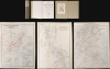
This item has been sold.
Geschichte des vierjährigen bürgerkrieges in den Vereinigten Staaten von Amerika.
Prussian Military Officer's Take on the U.S. Civil War.
Prussian Military Officer's Take on the U.S. Civil War.
This is the first edition of Constantin Sander's account of the 1865 U.S. Civil War. Written for a German audience, Sander's work offers a technical events-driven synthesis of the war with all of the precision and detail one would expect of an academy-trained Prussian officer. Sander's highly technical work became an essential strategic and tactical reference in modern warfare for his fellow Prussian officers, who would go on to defeat both Austria and France in the following years.A Closer Look
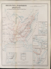
In addition to Sander's near 600 pages of text, the book includes three folding maps.- The first provides an overview of the conflict and is based on Johnson's New Military Map of the United States (previously offered by us in its several editions). It includes insets of the Southern ports of Mobile, Charleston, and Wilmington (North Carolina), as well as comparative maps of the United States (excluding western states and territories) and German states on the same scale, drawn from the Hand-Atlas of Emil von Sydow (1812 - 1873), who, like Sander, was a Prussian military officer and geographer.
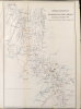
- The second map covers Gen. Sherman's operations in Georgia, also known as the 'March to the Sea,' and is based on a U.S. Coast Survey map.
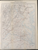
- The third map is also based on a Coast Survey map (also offered by us, EasternVirginia-nicholson-1862), and covers the scene of military campaigns around the Potomac, Shenandoah, and James Rivers, in other words, the main 'seat of the war' around Washington, D.C. and Richmond.
German Interest in the U.S. Civil War
The U.S. Civil War was a topic of keen interest to readers in the German states. For one thing, many German immigrants had come to the U.S. in the preceding years, especially with the failure of the Revolutions of 1848, and over 200,000 German-born troops fought in the Civil War, generally for the Union. The Union also boasted prominent German-born generals like Franz Sigel and Carl Schurz (both 'Forty-Eighters'). Germans were largely opposed to slavery, and German lands were less reliant on Southern cotton than Britain, for instance, so there was little sympathy for the Confederacy. German intellectuals also associated the goal of preserving the Union with their own project of German national unification.A final motivation, the one most directly related to this book's production, was German (and specifically Prussian) military interest in the conflict. Sander was a Prussian artillery officer, and there was a debate among Prussian military minds as to whether rifled artillery made fortifications obsolete. Therefore, Sander's account included extensive technical discussions on the impact of artillery on fixed fortifications. The book was published only one year before Austro-Prussian War (June 14, 1866 - August 23, 1866) and only five years before Franco-Prussian War (1870 - 1871) and served as an important manual on state-of-the-art military technology, tactics, and strategy.
Sander's book was one of the earliest book-length German narratives of the American Civil War (1861 - 1865). In addition to his focus on artillery and fortifications, his account emphasizes operational and tactical history, especially the campaigns of 1863 - 1865 (Gettysburg to the fall of Richmond), while sketching the political origins and the first two war years more briefly. The contemporary military perspective and close focus on battles and commanders make it a distinctly events-driven synthesis for a German audience.
Publication History and Census
This is the first (1865) edition of Constantin Sander's Geschichte des vierjährigen bürgerkrieges in den Vereinigten Staaten von Amerika, published in Frankfurt am Main by J.D. Sauerländer's Verlag. The maps were prepared by Prussian military officers, one surnamed Sohn and the other being Lieutenant von Fragstein II, and were lithographed in Darmstadt by Maximilian Frommann. The bookplate on the inside of the front cover indicates provenance, but is not fully legible; it may be 'Fritsche' or a variant spelling of the same name, a fairly common surname.A substantially expanded second edition of the book appeared with the same publisher in 1876 (edited by Ferdinand Franz Mangold; 792 pp.), reflecting postwar sources and revised judgments, and the book has recently been republished (Fines Mundi, Saarbrücken, 2013/2016) with facsimiles of the 1865 Frankfurt text and maps. A census of this first edition is difficult to establish due to the intermingling of multiple editions and of physical, microform, and digital examples in catalog listings; we note holdings by about a dozen institutions in North America.
Cartographer
Maximilian Joseph Frommann (1813 - 1866) was a lithographer based in Darmstadt, Germany. Little information is available on his life and work. The 1849 edition of the Allgemeines Adreßbuch für den deutschen Buchhandel, den Antiquar-, Colportage-, Kunst- Landkarten- und Musikalien-Handel lists Frommann as going into business in 1835. After his death, his daughter Anna and son-in-law Georg Bünte continued the business as Frommann and Bünte, while his son Friedrich formed his own firm with Friedrich Morian, named Frommann and Morian. Both the original Frommann firm and its successors particularly specialized in publishing chromolithographed playing cards. Further Details...
Condition
8vo. First edition. 587 pp. With three large, multi-folding color lithographed maps. Rebound in contemporary linen with manuscript title. The maps are loose, had have a few minor verso repairs to typical edge and binding point tears repaired on verso. Reinforcement at fold intersections.
References
OCLC 63552927.