This item has been sold, but you can get on the Waitlist to be notified if another example becomes available, or purchase a digital scan.
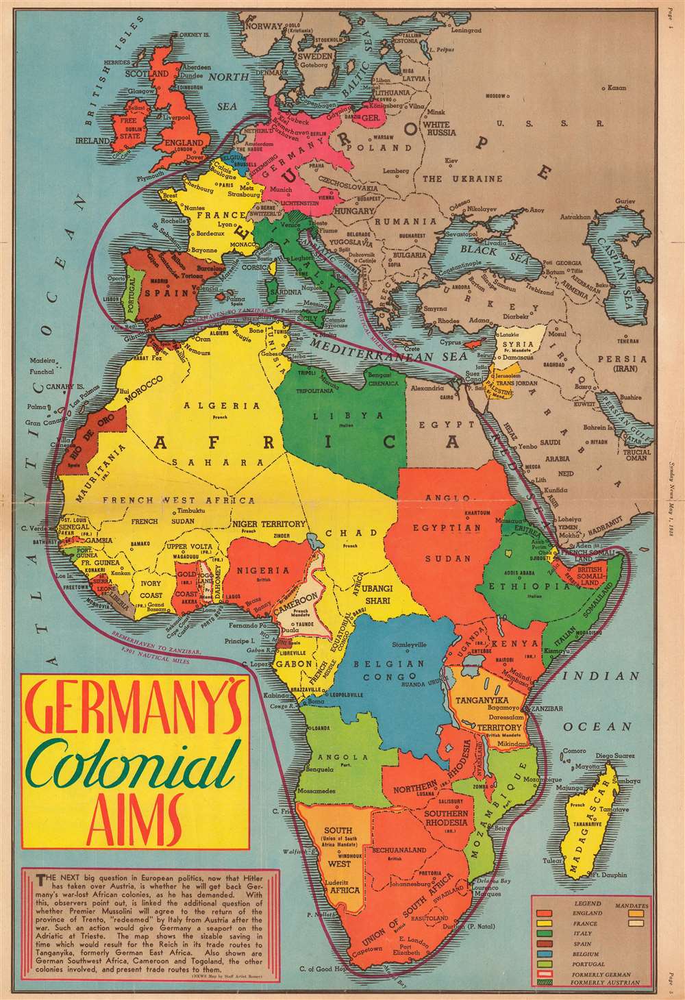
1938 Romer Map of Colonial Africa
ColonialAims-romer-1938$112.50

Title
Germany's Colonial Aims.
1938 (dated) 22 x 15 in (55.88 x 38.1 cm) 1 : 22000000
1938 (dated) 22 x 15 in (55.88 x 38.1 cm) 1 : 22000000
Description
This is a 1938 Jack Romer map of Africa highlighting various world power's colonial possessions throughout the continent only a year before the outbreak of World War II. The map depicts the region from the Atlantic Ocean to the Soviet Union and the Indian Ocean and from Norway to the Cape of Good Hope. Romer uses different colors to differentiate between the colonial holdings of seven different world powers: England, France, Italy, Spain, Belgium, Portugal, and Germany, although Germany lost its African colonies as a result of the Treaty of Versailles which ended World War I.
In Europe, a northeastern portion of Italy, the Tyrol and the portion of the country near Trieste, which had once belonged to Austria, were returned to Italy after the Anschluss, the Nazi German annexation of Austria. Perhaps the most intriguing piece of cartography, however, is the depiction of a 'Greater Germany' after the Anschluss that includes Austria, without labeling Austria, but labeling Vienna. This foreboding geographical inclusion, printed on a map published less than two months after the Anschluss, in hindsight, definitely brings storm clouds down upon this piece. Intriguingly, in the text box in the lower left corner, the newspaper posits the question of how much farther will Hitler and Nazi Germany go before they are sated.
Ephemeral Cartography
Several different short-lived historical events are illustrated here. Beginning in Africa, since that continent is the focus of this map, it is important to note that Italy is in control of Ethiopia and Eretria, the result of the Second Italo-Ethiopian War, and would remain in control of the Ethiopian Empire until the British defeat of the Italian army in the region during the East African Campaign of World War II. Germany's former colonies, Togo, Cameroon, Namibia (South West Africa), and Tanganyika are bordered in thick red lines. These territories became British and French mandates after World War I.In Europe, a northeastern portion of Italy, the Tyrol and the portion of the country near Trieste, which had once belonged to Austria, were returned to Italy after the Anschluss, the Nazi German annexation of Austria. Perhaps the most intriguing piece of cartography, however, is the depiction of a 'Greater Germany' after the Anschluss that includes Austria, without labeling Austria, but labeling Vienna. This foreboding geographical inclusion, printed on a map published less than two months after the Anschluss, in hindsight, definitely brings storm clouds down upon this piece. Intriguingly, in the text box in the lower left corner, the newspaper posits the question of how much farther will Hitler and Nazi Germany go before they are sated.
Publication History and Census
This map was created by Jack Romer and published by the New York Sunday News on May 1, 1938. We have been unable to locate any other catalogued examples.Cartographer
Jack Romer (1898 - April 28, 1967) was a staff artist for the New York Daily News who produced maps and charts for publication in the newspaper. Romer began working for the New York Daily News around 1932 and worked there until his death. More by this mapmaker...
Condition
Good. Wear along original fold lines. Two tears extending one half inch into printed area professionally repaired on verso. Closed margin tears professionally repaired on verso. Verso reinforcement and repairs along centerfold. Area of right margin reinstated. Text and advertisements on verso.