
1943 Linn Westcott Pictorial Map of the Railroads of Colorado


Colorado Railroads.
Pictorial map of Colorado's historic railways.
- Digital Map Information
- Suitable for large format printing
- Full resolution TIFF file
- ICC color profile embedded
- Delivered instantly via download link
Pictorial map of Colorado's historic railways.
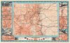
This is a dramatic 1943 Linn H. Westcott / Trains Magazine pictorial map of Colorado highlighting its historic railroads. The map captures Colorado's complex and often confusing railroad history and its influence on westward expansion, mining booms, urbanization, and tourism.A Closer Look - Colorado's Railways
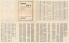
Coverage embraces the state of Colorado with more than 100 railroads mapped and named via an index on the verso. Colorado's impressive topography is strikingly illustrated, and the influence it had on the state's railways is immediately apparent. Among the railroads illustrated are the Denver and Rio Grande Western, the Burlington Route, the Colorado and Southern, the Rock Island, the Union Pacific, the Santa Fe Line, and the Western Pacific Lines. Rail lines are categorized by 'standard' or 'narrow' gauge, as well as by their operational status (currently operating vs. abandoned) and the type of propulsion (electric vs. rack and pinion). The red text identifies rail passes, gorges, whether the routes are curvy or straight, and other important information. Numerous smaller detail maps surround the map and illustrate the region around Leadville, Silverton-Ouray-Telluride, Cumbres Pass, Canon City-Royal Gorge-Florence, Pueblo, Colorado Springs-Manitou-Pikes Peak, and others. Six vignettes also appear around the map. Four of these celebrate the Denver and Rio Grande Western, including the famous 'Hanging Bridge' at the bottom center. One of the remaining two vignettes depicts the Georgetown Loop. An extensive index occupies the verso. It lists over 100 railroads along with cities and towns, mountains, creeks, rivers, and national parks.Publication History and Census
This map was created by Linn H. Westcott for Trains Magazine and was published by Kalmbach Publishing Company. Well-represented in institutional collections.Cartographer
Linn Hanson Westcott (July 13, 1913 - September 8, 1980) was an American railroad enthusiast and model railroader, best known as the influential editor of Model Railroader magazine. Born in Los Angeles, California, Westcott attended Carleton College in Minnesota. Starting with publication of his contest-winning track plan in 1934, Westcott enjoyed 46 years of association with Model Railroader, serving 16 years as Editor (1961-1977), and following that as Editor Emeritus. Westcott made many innovative contributions to nearly every aspect of the hobby, and was creative and forward thinking in layout planning, modeling of equipment, scenery techniques, and electronics and control systems. He traveled widely in the US, making extensive documentation of prototype railroad structures, equipment, and practices. Westcott died in September of 1980 and was survived by his wife, Harriet, two sons, one daughter, and five grandchildren. Further Details...
Condition
Very good. Light wear along original fold lines. Index on verso. Accompanied by original paper sleeve.
References
OCLC 79447959.