This item has been sold, but you can get on the Waitlist to be notified if another example becomes available, or purchase a digital scan.
1859 Bachelder Map, Encampment of the Massachusetts Volunteers
ConcordMA-bachelder-1859$125.00


Title
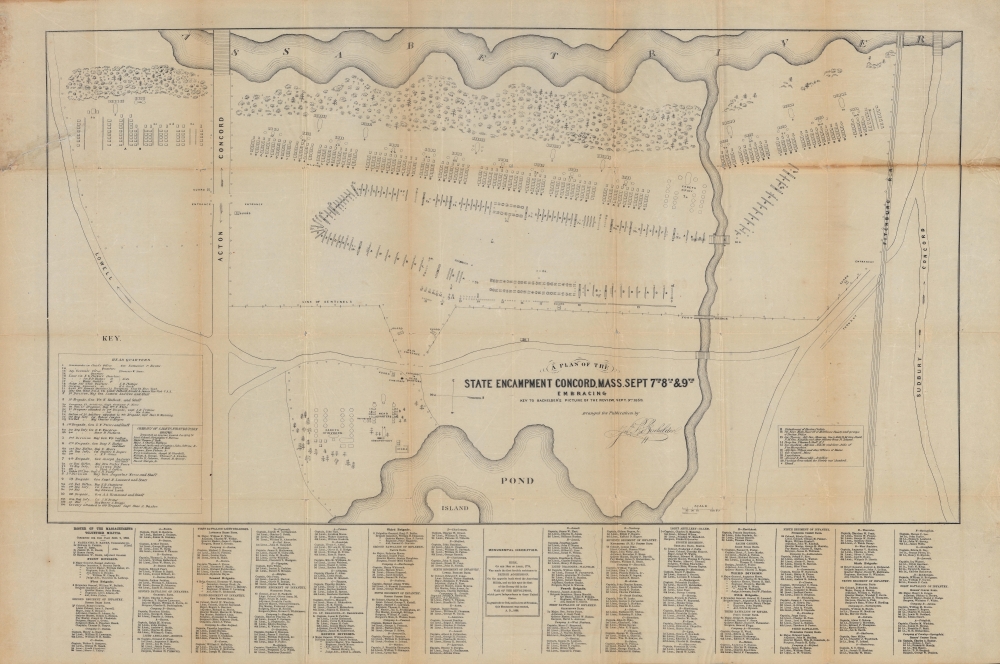
A Plan of the State Encampment Concord. Mass. Sept 7th 8th and 9th, Embracing Key to Bachelder’s Picture of the Review, Sept. 9th. 1859.
1859 (dated) 22 x 30.5 in (55.88 x 77.47 cm) 1 : 1800
1859 (dated) 22 x 30.5 in (55.88 x 77.47 cm) 1 : 1800
Description
A rare map produced in the run-up to the U.S. Civil War, this is an 1859 plan of the camp of the Massachusetts Volunteers in Concord, Massachusetts, published by John Bachelder. Though generally less effective than regular army units, such state militias played an important role in the early months of the Civil War as regular units were organized, outfitted, and trained.
In the years prior to the U.S. Civil War, as tensions around slavery and its expansion boiled over in places like Kansas and Nebraska, states began to more earnestly organize and train militia units. As a stronghold of abolitionism, Massachusetts was on the leading edge of these efforts in the north. State militia units did much of the fighting in the opening phase of the war but fared poorly against trained regulars.
Some of the officers listed here went on to command large armies during the conflict, most notably Nathaniel Banks, who was also the Governor of Massachusetts at the time of this map's publication (he had previously been a U.S. Representative and briefly served as Speaker of the House). Disliked by many contemporaries for his political slipperiness, including on the issue of slavery, as governor of one of the most critical northern states, Banks was nevertheless in a strong position to stake out a leading role in the conflict. Though he had left the governorship by the start of the war, Lincoln chose Banks as one of the first 'political generals,' that is military commanders with little to no wartime experience but with important political clout. Commanding volunteer militia and then regular units, Banks was easily one of the least successful Union commanders of the war and was a regular irritant for Ulysses S. Grant when the latter commanded Union forces in the war's Western Theater. His losses included the disastrous Red River Campaign against a much smaller and poorly equipped Confederate force in the final months of the war. After the war, Banks returned to the U.S. House, where he would spend much of the next thirty years.
A Closer Look
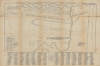
The plan is oriented towards the east with the Assabet River at top and a pond, now Warner's Pond, at bottom, connected by the Washoba Creek. The Fitchburg Railroad, now the Fitchburg Line of the MBTA's Commuter Rail network, runs along the right side of the plan. A detailed schematic displays the location of the camps of various locally raised militia units, whose officers are listed at bottom. Additional units and visitors, including cadets from Boston, officers from New Hampshire and Maine, and a detachment from the Massachusetts state legislature, are also indicated, along with sentinel posts, the band, a stable, an observatory, and other necessary fixtures of a military encampment. A box at bottom-center commemorates the Battle of Concord between Massachusetts militia and British regulars eighty-four years earlier.In the years prior to the U.S. Civil War, as tensions around slavery and its expansion boiled over in places like Kansas and Nebraska, states began to more earnestly organize and train militia units. As a stronghold of abolitionism, Massachusetts was on the leading edge of these efforts in the north. State militia units did much of the fighting in the opening phase of the war but fared poorly against trained regulars.
Some of the officers listed here went on to command large armies during the conflict, most notably Nathaniel Banks, who was also the Governor of Massachusetts at the time of this map's publication (he had previously been a U.S. Representative and briefly served as Speaker of the House). Disliked by many contemporaries for his political slipperiness, including on the issue of slavery, as governor of one of the most critical northern states, Banks was nevertheless in a strong position to stake out a leading role in the conflict. Though he had left the governorship by the start of the war, Lincoln chose Banks as one of the first 'political generals,' that is military commanders with little to no wartime experience but with important political clout. Commanding volunteer militia and then regular units, Banks was easily one of the least successful Union commanders of the war and was a regular irritant for Ulysses S. Grant when the latter commanded Union forces in the war's Western Theater. His losses included the disastrous Red River Campaign against a much smaller and poorly equipped Confederate force in the final months of the war. After the war, Banks returned to the U.S. House, where he would spend much of the next thirty years.
Publication History and Census
This map was prepared and published by John Bachelder in 1859. It was meant to accompany and serve as an index for Bachelder's lithograph 'Review of the Mass. Volunteer Militia: At Concord, Sept. 9, 1859' (OCLC 191909119), held by the Boston Athenaeum and the Library of Congress. Though the present map has an OCLC identifier, it is not noted among the holdings of any institution and is scarce to the market.Cartographer
John Badger Bachelder (September 29, 1825 – December 22, 1894), also spelled Batchelder, was an American portraitist, landscape artist, lithographer, cartographer, and photographer. In his life he was best known as the preeminent expert on the 1863 Battle of Gettysburg, of which he produced the most iconic representation. Bachelder was born in Gilmantown, New Hampshire and was educated at Captain Alden Partridge's Military School in Pembroke. Upon graduating he relocated to Reading, Pennsylvania, where he took a position at the Pennsylvania Military Institute. He became the head of that institution in 1851. In 1852 he was appointed colonel of the Pennsylvania State Militia. Around 1853 Bachelder returned to New Hampshire to pursue a career as an artist, publishing various views of New England towns; 1854 found him living and working in Manchester, and perhaps this is what led him to produce four views of the city - more than any other place he depicted in print. Bachelder's military training influenced his art materially and he developed a lifelong interest in depicting the dynamics of great battles on canvas. When the American Civil War broke out in 1861, Bachelder was working on a view of the Revolutionary War battle of Bunker Hill. From his work on the Bunker Hill view, Bachelder noted how difficult it was to reconstruct a battle long after the events when most major participants had passed on. He saw an opportunity in the outbreak of the Civil War and attached himself to the Union Army of the Potomac in the hopes of being present at a major battle. He was welcomed on the battlefield, where his accurate drawings helped the generals to better understand the conflicts in question. His most significant work his an impressive bird's-eye view of the Battle of Gettysburg. Though not present at the battle, he was there day's after, and claims to have interviewed the commanders of every regiment and battery in the Army of the Potomac, as well as thousands of wounded soldiers on both sides of the conflict. His work was so precise and significant he was commended to President Lincoln and later took a position as Superintendent of Tablets and Legends for the Gettysburg Battlefield Memorial Association. He is responsible for the monuments and battlefield markers, both Union and Confederate, that can still be noted today at Gettysburg. He also organized reunions and battlefield tours. Bachelder died of Pneumonia in Hyde Park, Massachusetts, in 1894. He is interred in his family plot in Nottingham, New Hampshire. More by this mapmaker...
Condition
Average. Wear and discoloration along fold lines with loss at fold intersections. Repaired tears near top at left and right along and near uppermost fold line.
References
OCLC 780709544.