1831 Thrall Pocket Map of Connecticut
Connecticut-thrall-1831$1,000.00

Title
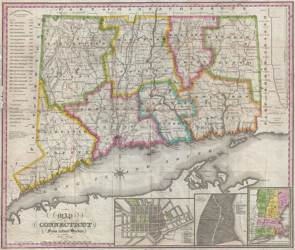
Map of Connecticut from actual Survey.
1831 (dated) 18.5 x 22.5 in (46.99 x 57.15 cm)
1831 (dated) 18.5 x 22.5 in (46.99 x 57.15 cm)
Description
A scarce map, this is Willis Thrall's 1831 pocket map of Connecticut, published in New Haven. It is a fine example of the short-lived but prosperous publishing community once based in Harford and New Haven.
A Closer Look
Thrall's map, which is dated at bottom center, covers Connecticut as well as the adjacent Long Island Sound. Connecticut is divided into eight color-coded counties. Inset plans of New Haven, Hartford, and the New England States occupy the lower right. The upper right features a profile of the Farmington Canal. A list of Connecticut governors in the upper left, starting with John Winthrop (1665), is updated to include John S. Peters (1831).Publication History and Census
According to the Connecticut map historian Edmond Thompson, this map was first engraved by Daggert and issued between 1827 and 1829. This is the second edition, published in 1831 with an update to the list of governors and the names of Thrall and Ely added to the imprint. It was later reissued by different publishers in 1836, 1847, 1854 and 1858. This edition and the virtually unknown first edition are by far the most desirable and found in few collections. It is also noteworthy that this map was published in New Haven, Connecticut.Cartographer
Willis Thrall (1800 - June 20, 1884) was an American businessman and map publisher based in Hartford Connecticut during the early part of the 19th century. His the son of Joel Thrall and Miriam Fitch, both of Both Bolton Connecticut. Thrall published numerous maps and also seems to have opened a tool and rule company in 1844, which he passed on to his son, Edward Thrall, as 'Will Thrall and Son'. No Thrall engravings appear after about 1836, suggesting he gave on on printing, but the tool company seems to have prospered. Thrall's most important print work was published in conjunction with D. W. Kellogg, with whom his family was associated by marriage. Thrall died in June of 1884 and is inferred at Spring Grover Cemetery, Hartford. More by this mapmaker...
Condition
Good. Detached from and missing original binder. Some minor damage just encroaching on the left border were once attached to binder - see image. Backed with archival tissue for stability.
References
Thompson, E., Maps of Connecticut for the Years of the Industrial Revolution 1801-1860, #78.