1878 Migeon Map of the Constantine Province, Algeria
Constantine-migeon-1878$100.00

Title
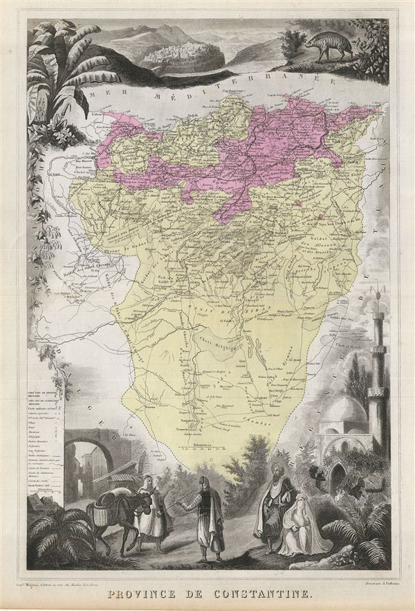
Province de Constantine.
1878 (undated) 18 x 12.5 in (45.72 x 31.75 cm)
1878 (undated) 18 x 12.5 in (45.72 x 31.75 cm)
Description
This is a fine example of J. Migeon's 1878 map of the Algerian Province of Constantine. The Department of Constantine existed from 1848 to 1962 and was one of the three administrative districts of French Algeria. The lower left quadrant contains a legend while the top and bottom of the map includes decorative engravings illustrating the Algerian landscape, the town of Oran, and the activities of the locals.
After being captured by the French in 1830, Algeria became an attractive destination for european immigrants. However the majority indigenous Muslim population was dissatisfied with the French dominated political system. This dissatisfaction would ultimately trigger the Algerian War and lead to Algeria's independence.
Migeon identifies various rivers, mountain passes, lakes and other topographical features are marked. Migeon's Geographie Universelle, published in Paris, is one of the last great decorative atlases of the 19th century. It contains many stylistic elements of early 19th century cartography such as full hand coloring, numerous decorative vignettes, and high quality paper. This map was issued in Migeon's Geographie Universelle.
CartographerS
J. Migeon (fl. c. 1855 - 1899) was a late 19th century map publisher based in Paris, France. At various times Migeon maintained offices at76, Rue de la Harpe, 34 Rue du Chemin des Plantes, and 11 Rue du Moulin Vert, all in Paris. His most prominent publications are the Geographie Universal in 1854 (updated through 1874) and the Nouvel Atlas Illustré de Géographie Universelle in 1891. Little is known of Migeon's life and even his first name is uncertain. More by this mapmaker...
Alexandre Aimé Vuillemin (1812 - 1880) was an engraver, publisher, and editor based in Paris, France in the middle of the 19th century. Despite a prolific publishing career, much of Vuillemin's life is shrouded in mystery. In 1852, he married Josephine Caroline Goret and they had at least one child, Ernestine Adèle Vuillemin, later in the same year. What is known is that his studied under the prominent French Auguste Henri Dufour (1798 - 1865). Vuillemin's most important work his detailed, highly decorative large format Atlas Illustre de Geographie Commerciale et Industrielle. Learn More...
Source
Migeon, J., Geographie Universelle (Paris) 1878.
Condition
Very good. Original centerfold. Blank on verso.