This item has been sold, but you can get on the Waitlist to be notified if another example becomes available, or purchase a digital scan.
1840 S.D.U.K. Map of Constantinople (Istanbul)
Constantinople-sduk-1840$100.00

Title
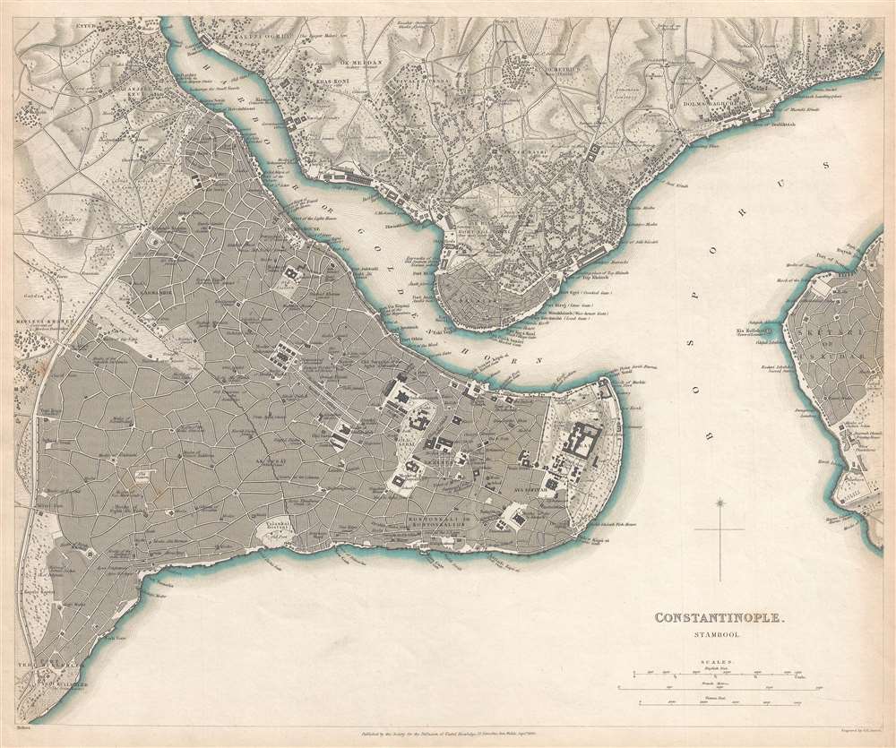
Constantinople. Stambool.
1840 (dated) 13 x 15.5 in (33.02 x 39.37 cm) 1 : 22000
1840 (dated) 13 x 15.5 in (33.02 x 39.37 cm) 1 : 22000
Description
This is an 1840 Society for the Diffusion of Useful Knowledge (S.D.U.K.) city map or plan of Constantinople, today known as Istanbul. Once known as Byzantium, the city was renamed Constantinople after Emperor Constantine the Great. It soon became the capital of the Eastern Roman Empire and then the capital of the Byzantine Empire after the fall of the Roman Empire. At the time of this map's printing, Constantinople was the capital of the Ottoman Empire, but by then its name had been changed to Istanbul. This map centers around the ancient city, depicting the Golden Horn with neighbouring Ghalatah, and Constantinople's Asian part ‘Üskudar. Considerable detail is used, labeling individual streets, markets, mosques, and other buildings.
This map was created for and published by the Society for the Diffusion of Useful Knowledge and engraved by Benjamin Rees Davies in 1840.
This map was created for and published by the Society for the Diffusion of Useful Knowledge and engraved by Benjamin Rees Davies in 1840.
CartographerS
The "Society for the Diffusion of Useful Knowledge" (1826 - 1848) was a Whiggish organization founded in 1828 at the instigation of idealistic British lord Henry Peter Brougham. The admirable goal of the Society was to distribute useful information via a series of publications to the English working and middle classes. It promoted self-education and the egalitarian sharing of all knowledge. While closely tied to the London University and publishing houses on the order of Baldwin and Cradock, Chapman and Hall, and Charles Knight, the Society failed to achieve its many lofty goals in finally closed its doors in 1848. Most likely the failure of the Society resulted from its publications being too expensive for its intended lower to middle class markets and yet not large and fine enough to appeal to the aristocratic market. Nonetheless, it did manage to publish several extraordinary atlases of impressive detail and sophistication. Their most prominent atlas consisted of some 200 separately issued maps initially published by Baldwin and Cradock and sold by subscription from 1829 to 1844. Afterwards, the Society combined the maps into a single world atlas published under the Chapman and Hall imprint. In its day, this atlas was unprecedented in its quality, scope, and cost effectiveness. Today Society, or S.D.U.K. as it is commonly known, maps are among the most impressive examples of mid-19th century English mass market cartographic publishing available. The S.D.U.K. is especially known for its beautiful and accurately detailed city plans. More by this mapmaker...
Benjamin Rees Davies (1789 - December 16, 1872) was an engraver, cartographer, painter, and map publisher active in the early to mid-19th century. Davies was born in Holborn, England, apprenticed as under John Lodge in 1803. He began publishing around 1811 and is known to have compiled many of own maps from original survey work. From approximately 1848 onward Davies published in conjunction with the Stanford Firm. He is also known to have engraved a number of maps for the Dispatch Atlas and the S.D.U.K. Davies was an early adopter of steel plate engraving and used the exceptional hardness of steel to create some of the most delicately engraved and beautifully produced maps of his era. He was quite famous in England for his detailed street plans of London, which he began publishing in 1848. Davies is known to have worked with numerous other cartographers of his period including French, Mexican, and American map makers. Many of his maps and plans continued to be published and updated posthumously well into the 1880s. Learn More...
Condition
Very good. Even overall toning. Blank on verso.
References
Branch, M.C. An atlas of rare city maps, p. 96-97. Rumsey 0890.169.