This item has been sold, but you can get on the Waitlist to be notified if another example becomes available.
1943 Showa 18 East Asian Co-Prosperity Sphere Full Map Set (20 Maps)
CoProsperitySet-showa18-1943-2$900.00

Title
標準大東亞分圖 / Standard Map of the Great East Co-Prosperity Sphere.
1943 (dated) 21 x 29.5 in (53.34 x 74.93 cm)
1943 (dated) 21 x 29.5 in (53.34 x 74.93 cm)
Description
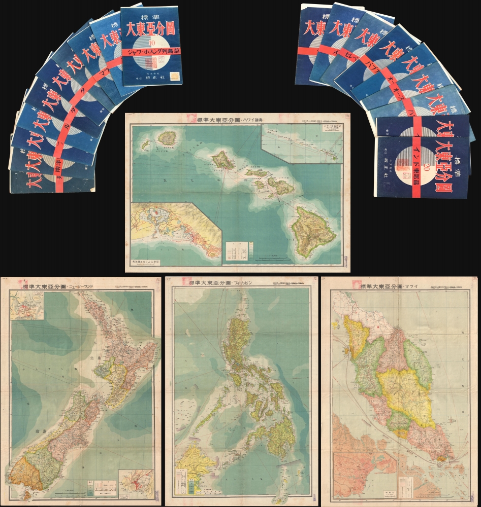
This is an important full set of 20 maps from the 1943 Showa 18 World War II (WWII) Greater East Asian Co-Prosperity Sphere series, by Seitosha (正統社). The maps cover from India to Hawaii and from Japan to Australia, reflecting the Japanese Imperial vision of Pan-Asianism.
The Greater East Asia Co-Prosperity Sphere
The Greater East Asia Co-Prosperity Sphere (大東亜共栄圏) was an imperial concept created and promulgated for occupied Asian populations by the Empire of Japan. The concept was announced by Japanese Foreign Minister Hachirō Arita on June 29, 1940. The Co-Prosperity Sphere was intended as a self-sufficient 'bloc of Asian nations led by the Japanese and free of Western powers.' It covered Southeast Asia, Eastern China, Manchuria, Japan, the East Indies, and parts of Oceania. The idea promoted the cultural and economic unity East Asians, Southeast Asians, and Oceanians with the underpinning assumption that Japan, which had never been conquered and was the only Asian nation to fully modernize, was the 'Light of Asia.'Contents
The set includes:- Co-Prosperity Sphere General Map
- Marshall Islands / Micronesia
- Philippine Islands
- Luzon, Philippines Islands
- Indochina
- Thailand
- Burma
- Malay / Sumatra
- Malay / Singapore
- Java
- Java II
- Borneo
- Celebes
- New Guinea
- Australia
- Western Australia
- New Zealand
- Hawaii
- India
- Northern India
Publication History and Census
The Co-Prosperity Sphere map series was published by Seitosha (正統社) and designed by Ashizawa Keigo (芦沢馨吾). It was distribued by the Japan Publishing and Distribution Company, Ltd. (日本出版配給株式會社). The present example is the second 1943 edition. Maps from this set do appear on the market from time to time, but a complete set is exceedingly rare.CartographerS
Seitosha (正統社; fl. 1930 - 1949) was a Japanese publishing house active in Tokyo during the early to mid-20th century, particularly active during the wartime period of the 1930s and 1940s. Seitosha was known for official government publications, which, during this period, had a nationalistic and military leaning. During World War II, the Japanese government tightly controlled and censored publications, and Seitosha, like many other publishers, had to adhere to these strict regulations. After the war, with the democratization and demilitarization of Japan, many such publishing houses either adapted to the new environment or ceased operations. The fate of Seitosha is unclear, but we see no activity after 1950. More by this mapmaker...
Ashizawa Keigo (芦沢馨吾; fl. c. 1930 - 1949) was a Japanese editor and cartographic illustrator most active during World War II. Most of his known work is associated with the publisher Seitosha (正統社; fl. 1930 - 1949). Learn More...
Japan Publishing Distribution Co., Ltd. (日本出版配給株式會社; May 5, 1941 - March 28, 1949), was a nationalized joint-stock publishing company active during the World War II period in Japan. Established on May 5, 1941 (Showa 16). The government supported firm consolidated more than 200 independent publishers as a national propaganda network. The published under the guidance of the Ministry of Commerce and Industry and the Japan Publication Cultural Association. After the War, from 1946 (Showa 21), the company was returned to private management and renamed Nihon Shuppan Distribution Control Co., Ltd. The constituent firms dispersed shortly afterwards and by 1949 the Japan Publishing Distribution Co., Ltd. Some of the breakaway firms still publish. Learn More...
Condition
Very good. All maps come with original blue paper folders. Some are slightly more faded than others or may have wear and/or verso reinforcement on original fold lines or at fold intersections. Some have pinholes in corners. All bear title stamp and deaccession stamp. All maps measure roughly 21 x 29.5 inches.