This item has been sold, but you can get on the Waitlist to be notified if another example becomes available.
1960 Coral Gables Self Guided Tour Map
CoralGables-guidepublishing-1960$125.00


Title
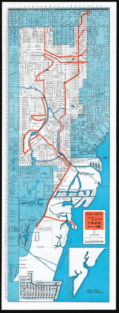
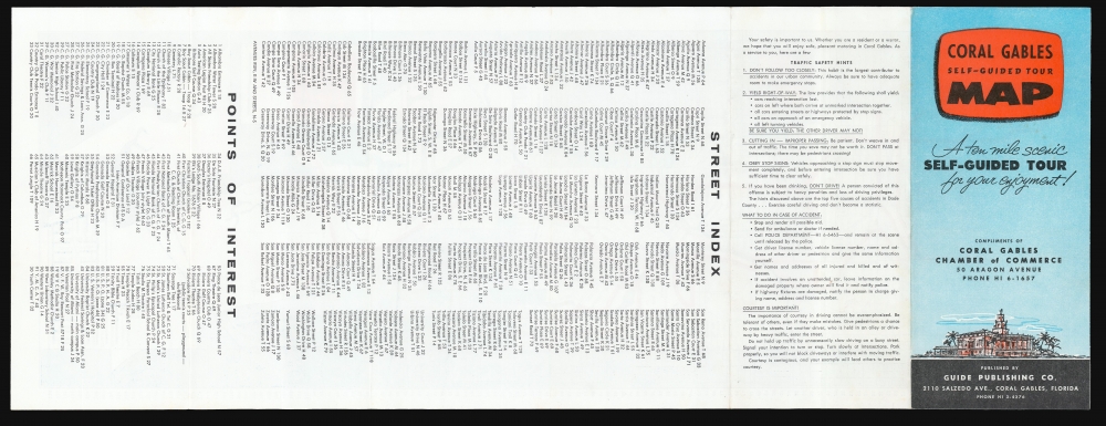
Coral Gables Self-Guided Tour Map: A ten mile scenic Self-Guided Tour for your enjoyment!
1960 (undated) 23 x 8.25 in (58.42 x 20.955 cm) 1 : 23000
1960 (undated) 23 x 8.25 in (58.42 x 20.955 cm) 1 : 23000
Description
This is a c.1960 map of Coral Gables, Florida printed by Guide Publishing and distributed by the Chamber of Commerce. It marks out a 'self-guided' tour through the city from Matheson Hammock Park and Marina, up Old Cutler Road, and then on a loop through town to the University of Miami, Riviera Golf Course and beyond; the northern limit of the map is West Flagler.
Between these two comes Guide Publishing Co. We are aware of two versions of their Coral Gables Self-Guided Tour: seven institutional collections list one of these, subtitled A ten mile scenic self-guided tour of 'the city beautiful.' This differs from ours, which bears instead, A ten mile scenic self-guided tour for your enjoyment'. Typographically, the text relating to 'the city beautiful' appears to be later compared to the text of the present example, suggesting that ours is the earlier. More tellingly, the examples listed in institutions bear a telephone number for the Chamber of Commerce using the modern, seven-digit format. Ours uses the older, five-digit format appearing on the 1950s Larson maps. If the institutional copies' 1962 dating is correct, ours is unlikely to be later than 1961.
Helpful Details
The verso of the map contains a street index and a similar index of 'Points of Interest,' both keyed to the map with coordinates. A distinction between this and the later state of the map (see below) is a set of 'Safety Hints' for visiting drivers to the city: Don't follow too closely! Be sure you yield, the other driver may not! Don't weave in and out of traffic! Obey stop signs!A Rare, Early Issue
The Coral Gables Chamber of Commerce, never lax in promoting the city, commissioned a series of maps on the 'Self-Guided Tour' theme. From 1956 to 1959, that job went to the firm of L.W. Larson. In 1966, we see a map of the same title being published by Avel Map and Advertising.Between these two comes Guide Publishing Co. We are aware of two versions of their Coral Gables Self-Guided Tour: seven institutional collections list one of these, subtitled A ten mile scenic self-guided tour of 'the city beautiful.' This differs from ours, which bears instead, A ten mile scenic self-guided tour for your enjoyment'. Typographically, the text relating to 'the city beautiful' appears to be later compared to the text of the present example, suggesting that ours is the earlier. More tellingly, the examples listed in institutions bear a telephone number for the Chamber of Commerce using the modern, seven-digit format. Ours uses the older, five-digit format appearing on the 1950s Larson maps. If the institutional copies' 1962 dating is correct, ours is unlikely to be later than 1961.
Publication History and Census
This map was published by the Guide Publishing Co. in Coral Gables, as early as 1960. This state of the map is not listed in institutional collections. Seven university collections hold examples of the later 'city beautiful' state of the map.Cartographer
Guide Publishing Co. (fl. 1958-1963) Was an American commercial publisher based in Coral Gables, Florida. They share the name of several publishing firms around the country and it is unclear if there was any relationship between any of them; it may have been a branch of a larger company, or it may have been entirely local. They are known to have produced several maps on behalf of the Coral Gables Chamber of Commerce, including a c. 1960 'Coral Gables Self Guided Tour Map' and, in the late 50s, 'Pocket guide, Greater Miami.' More by this mapmaker...
Condition
Excellent. Original fold lines.
References
cf. OCLC 5493348.