This item has been sold, but you can get on the Waitlist to be notified if another example becomes available, or purchase a digital scan.
1895 Italian Map of the First Sino-Japanese War
Corea-anon-1895$150.00

Title
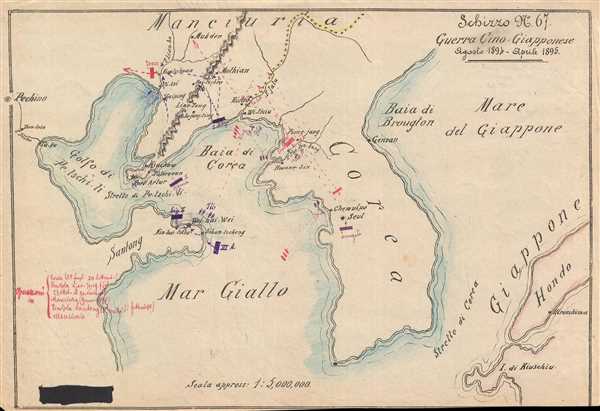
Schizzo No. 67 Guerra Cino - Giapponese Agosto 1894 - Aprile 1895.
1895 (undated) 8 x 12 in (20.32 x 30.48 cm) 1 : 5000000
1895 (undated) 8 x 12 in (20.32 x 30.48 cm) 1 : 5000000
Description
This is an 1895 Italian map of the theater of war during the First Sino-Japanese War. The map centers on the Korean peninsula, which was the main theater of war, and depicts from Beijing (Pechino) to Japan and from Manchuria to the Shandong Peninsula. The map itself appears to be printed, but notations relating to the First Sino-Japanese War are in manuscript. Japanese forces are illustrated in purple ink, while Chinese forces are in red. The major engagements of the war are illustrated using these manuscript notations, including the Port Arthur Massacre and the fall of Wei-Hai-Wei. Following the capture of Wei-Hai-Wei, the Japanese controlled the sea lanes to Beijing, and, although the Chinese did not sue for peace immediately, this battle at Wei-Hai-Wei was the last major engagement of the war. Several locations throughout the region are labeled, including Seoul, Pyongyang, the Yalu River (which today serves as the border between China and North Korea), Port Arthur, and Hiroshima.
Although the map is not signed, this is an incredibly intriguing piece and would make a unique addition to any collection.
Although the map is not signed, this is an incredibly intriguing piece and would make a unique addition to any collection.
Condition
Very good. Blank on verso.