This item has been sold, but you can get on the Waitlist to be notified if another example becomes available, or purchase a digital scan.
1823 Jefferys and Laurie Map of Corsica
Corsica-laurie-1823$275.00

Title
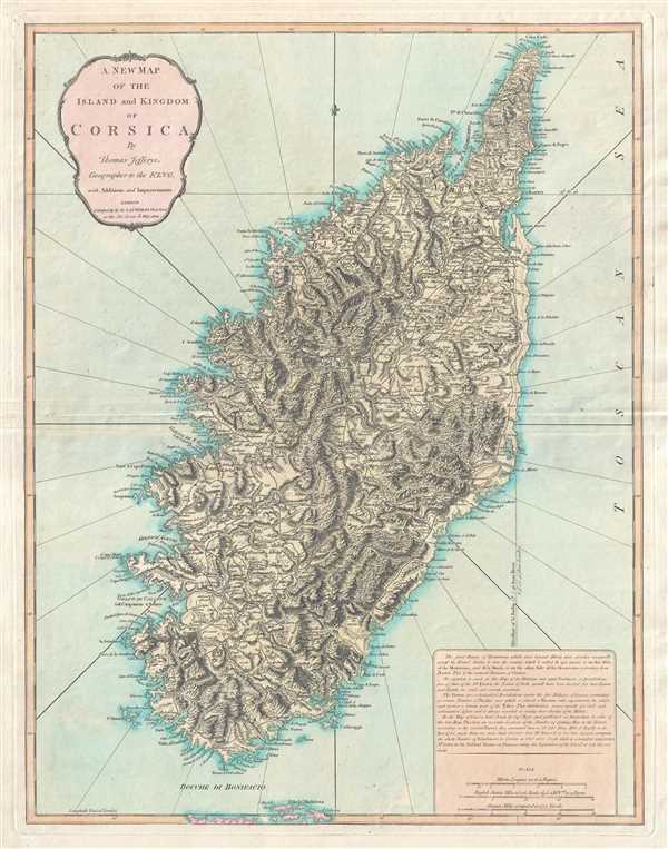
A New Map of the Island and Kingdom of Corsica.
1823 (dated) 25.5 x 19.75 in (64.77 x 50.165 cm) 1 : 300000
1823 (dated) 25.5 x 19.75 in (64.77 x 50.165 cm) 1 : 300000
Description
This is an 1823 Thomas Jefferys and Richard Holmes Laurie map of Corsica. Beautifully engraved, the map depicts the entire island in considerable detail along with the extreme northern region of Sardinia. Myriad cities, towns, and villages are labeled, along with several bays and other coastal areas. Roads are illustrated throughout the island and Corsica's topography is exquisitely rendered. A short description of the physical and political geography of the island, along with three different scales, is situated in the lower right corner.
A Short History of Corsica in the 17th and 18th Centuries
In 1729 the Corsican Revolution for independence from the Republic of Genoa began. After twenty-six years, in 1755, the independent Corsican Republic was proclaimed, though the Genoese did not recognize its independence. In 1767, following the Corsican conquest of Capraia, the Genoese decided to sell the island to France and cede to the French all rights to the island. The French conquered Corsica in 1769, effectively ending the Corsican Republic. In 1789, following the outbreak of the French Revolution, the Corsican nationalist Pasquale Paoli returned home from exile in Britain. Paoli invited British forces to intervene to free Corsica from French rule in 1794 and a joint Anglo-Corsican force drove the French from the island and created an Anglo-Corsican Kingdom. British forces, however, decided to withdraw from Corsica in 1796, after Spain entered the war. With Britain's exit, French rule returned to the island.
This map was created by Thomas Jefferys and published by Richard Holmes Laurie in 1823.
CartographerS
Thomas Jefferys (1695 - November 20, 1771) was one of the most prominent and prolific map publishers and engravers of his day. Jefferys was born in Birmingham and was apprenticed to the engraver Emmanuel Bowen in 1735. Later, in the 1740s he engraved several maps for the popular periodical Gentleman's Magazine. Around 1740 Jefferys was finally able to go into business for himself and in 1746 received an appointment as 'Geographer to Fredrick, Prince of Wales,' which shortly after translated to the position of 'Royal Cartographer to King George III.' Jefferys initially specialized in compiling and re-engraving the works of earlier cartographers into more coherent cartographic wholes. Later, while not salaried position, Jefferys' appointment as 'Royal Cartographer' guaranteed preferential access to the most up to date cartographic material available, allowing him to produce new and updated charts of exceptional accuracy. He his best known for his maps of the Americas, particularly the posthumously published 1775 American Atlas, which included some of the finest and most important late colonial era maps of America ever made. Despite his prolific publishing history, royal appointments, and international publishing fame, Jefferys lived most of his life in dire economic straits. He was bailed out of bankruptcy by Robert Sayer during the production of the American Atlas. In the end, Jefferys died suddenly with very little to his name. Nonetheless, his cartographic legacy survived, and even after his death in 1771, many of his important maps continued to be published and republished by Sayer and Bennet, Conrad Lotter, Georges Louis Le Rouge, Laurie and Whittle, and others. Many attribute some of Jefferys best maps to the colorful and criminally inclined Irish cartographic genius Braddock Mead (John Green, c. 1688 - 1757), who is considered the 'secret behind Jefferys.' Jefferys was succeeded by his son, also Thomas, who had little success as a cartographer and eventually partnered with, then sold his stock and plates to William Faden - Jefferys' true heir. More by this mapmaker...
Richard Holmes Laurie (December 2, 1777 - January 19, 1858) was a British map and chart publisher and seller. Born in London to publisher Robert Laurie and his wife Esther Jouret, R. H. Laurie took over his father's share of the Laurie and Whittle publishing firm upon his father's retirement in 1812 and began trading as Whittle and Laurie. After Whittle died in 1818, Laurie continued the business by himself, trading under the imprint R. H. Laurie. During the 1820s and 1830s, Laurie expanded the nautical chart business until he was overtaken by Admiralty charts. Laurie married Susan Ann Coates on February 6, 1814 and later married Mary Ann Dennison on October 15, 1833. He left his business and all his property in trust for his two surviving daughters (both of whom were minors) with his principal engraver, Alexander George Findlay. Findlay continued the business in Laurie's name after acquiring its equity from his daughters. Learn More...
Condition
Very good. Even overall toning. Verso repair to centerfold separation. Blank on verso.