This item has been sold, but you can get on the Waitlist to be notified if another example becomes available, or purchase a digital scan.
1838 Spanish Nautical Chart or Map of Sardinia, Corsica, Minorca
CorsicaSardinia-direccionhidrografia-1838$550.00

Title
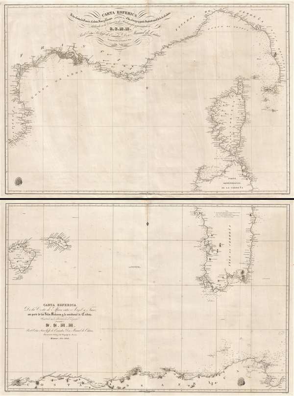
Carta esférica de las costas de Francia, Cerdeña, Luca y Toscana con las yslas de Elba, Córcega y parte septentrional de la de Cerdeña. / Carta Esférica de la Costa de Africa entre Argel y Tunez con parte de las Yslas Baleares y la meridional de Cerdeña.
1838 (dated) 50 x 37 in (127 x 93.98 cm) 1 : 767000
1838 (dated) 50 x 37 in (127 x 93.98 cm) 1 : 767000
Description
This is a rare 1838 two-part Spanish nautical chart of the western Mediterranean in the vicinity of Corsica, Sardinia, and the Balearic Islands. The map covers from Majorca (Mallorca) and Menorca (Minorca) east to Sardinia and Corsica and from the French Rivera to the north Africa coast. Both charts are beautifully engraved with superb coastal detail throughout.
It was issued by the Direccion de Hidrografia, a Spanish naval mapping organization, and first published din 1839. The OCLC recognizes a later updated edition prepared in 1897, but he present offering is the 1838 first edition. Both charts were drawn under the order of Don Manuel de Cañas. The upper chart was engraved by Clemente Noguera and the lower chart by Juan Carrafa. Both charts were drawn by José Espejo with letter engraving by C. Marquerie.
It was issued by the Direccion de Hidrografia, a Spanish naval mapping organization, and first published din 1839. The OCLC recognizes a later updated edition prepared in 1897, but he present offering is the 1838 first edition. Both charts were drawn under the order of Don Manuel de Cañas. The upper chart was engraved by Clemente Noguera and the lower chart by Juan Carrafa. Both charts were drawn by José Espejo with letter engraving by C. Marquerie.
CartographerS
The Direccion Hidrografía (1787 - 1927), also known as the Deposito Hydrografico and the Direction de Hidrografía, was the Spanish equivalent of the British Admiralty or the U.S. Coast Survey. This organization, founded in 1787, was commissioned to collect and produce accurate nautical charts of all waters frequented by Spanish vessels. In essence, it replaced the Casa de la Contratación de las Indias (House of Trade of the Indies), which closed its doors in 1790. Like most such organizations, the Direccion Hidrografía marked a new age in cartography. Rather than simply collect charts created by navigators, explorers, and merchants, the Direccion Hidrografía worked closely with naval and military personnel to mount cartographic and hydrographic expeditions in pursuit of the most accurate hydrographical, astronomical, and geodetic measurements. The Direccion Hidrografía created a massive library of nautical charts that, though not nearly as common as similar nautical charts by the U.S. Coast Survey and British Admiralty, are highly desirable for the beauty of their manufacture as well as their accuracy and detail. The office was originally located on Calle Ballesta, but relocated to 36 Alcala, both in Madrid. After 1908 the Dirección was subsumed into other governmental agencies. In 1927 the Direccion was absorbed into the Institute and Observatory of San Fernando, located in Cadiz. The library of original maps, charts, and journals was transferred to the Naval Museum of Madrid - where it resides to this day. More by this mapmaker...
Clemente Noguera (fl. c. 1809 – 1860) was a Spanish draftsman, naval pilot, and engraver based in Madrid during the middle part of the 19th century. Little is known of Noguera, but he was active as an engraver as early as 1809, when he engraved a plan of Zaragoza, Spain. He was a second lieutenant of the Spanish Navy in 1830. By, 1850, Noguera was a senior draftsman for the Direccion de Hidrografia. Clemente Noguera should not be confused with Juan Noguera, who was also a senior line-engraver at the Direccion de Hidrografia. The two engravers may or may not be related. Clemente was significantly older than Juan, and may have been an older relative. Learn More...
Condition
Very good. Minor wear and toning on original fold lines. Even overall toning. Measurement provided reflects the combined charts, as in the image above.
References
OCLC 913895147 / 556288232.