This item has been sold, but you can get on the Waitlist to be notified if another example becomes available, or purchase a digital scan.
1764 Bellin Map of the Gulf Coast of the United States
CostesLouisianeFloride-bellin-1764$2,400.00

Title
Carte Reduite des Costes de la Louisiane et de la Floride.
1764 (dated) 23.5 x 34.5 in (59.69 x 87.63 cm) 1 : 2500000
1764 (dated) 23.5 x 34.5 in (59.69 x 87.63 cm) 1 : 2500000
Description
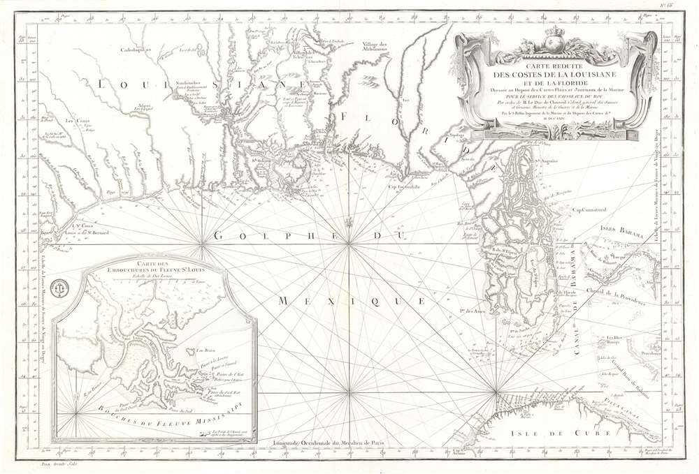
This is a 1764 Jacques-Nicolas Bellin map of the Gulf Coast of the United States featuring an exceptional depiction of Florida as an archipelago. Illustrating the Gulf region from Galveston Bay (Baye St. Louis) to the Bahamas and from the southern United States to Cuba, numerous coastal useful for navigation are incorporated. Coastal islands, capes, bays, and river mouths are all noted, including Mobile Bay, the St. John's River, and the Mississippi Delta. Depth soundings are present where they have been taken. St. Augustine and New Orleans are labeled, as are several coastal forts. Indian villages are identified in the interior, as are rivers and a lead mine in modern-day Texas. Rhumb lines appear throughout, and Dry Tortugas in the Florida Keys and individual islands in the Bahamas are notated. An inset map in the lower left corner illustrates the mouth of the Mississippi River.
Scholars believe that Nairne, like most European visitors, based his geographical knowledge of the interior of Florida primarily upon indigenous sources. In Europe, Guillaume de l'Isle, one of France's most influential Enlightenment cartographers, used Nairne's Florida on his 1718 map Carte de la Louisiane et du Cours du Mississipi. De l'Isle's map secured widespread popularization of Florida-as-archipelago, establishing it as convention for the subsequent century. Between 1711 and 1799, at least seventeen maps from multiple cartographic traditions depict Florida as an archipelago, although not all used the same cartography. Florida's return to peninsular status follows Bernard Romans's 1775 book A Concise History of East and West Florida, although this truth would take decades to become universally accepted.
Florida as an Archipelago
The mapping of Florida as an archipelago originated with Thomas Nairne's now lost Map of South Carolina Shewing the Settlements of the English, French, and Indian Nations from Charles Town to the River Missisipi. Knowledge of Nairne's map survives through of Edward Crisp's 1711 A Compleat Description of the Province of Carolina, in which it is included as an inset reduction. Michele Currie Navakas, in her article 'Island Nation: Mapping Florida, Revising America,' identifies Nairne's slave raid as the source for this map and the archipelago model. In 1702, Nairne and thirty-three Yamasee raided the Floridian interior, capturing thirty-five Florida Indians, who were subsequently sold as slaves in South Carolina. Misinterpreting the complex Florida swamp and river systems, and the enormity of the Everglades, Nairne determined that Florida was not a peninsula, but an archipelago.Scholars believe that Nairne, like most European visitors, based his geographical knowledge of the interior of Florida primarily upon indigenous sources. In Europe, Guillaume de l'Isle, one of France's most influential Enlightenment cartographers, used Nairne's Florida on his 1718 map Carte de la Louisiane et du Cours du Mississipi. De l'Isle's map secured widespread popularization of Florida-as-archipelago, establishing it as convention for the subsequent century. Between 1711 and 1799, at least seventeen maps from multiple cartographic traditions depict Florida as an archipelago, although not all used the same cartography. Florida's return to peninsular status follows Bernard Romans's 1775 book A Concise History of East and West Florida, although this truth would take decades to become universally accepted.
Publication History and Census
This map was created by Jaques-Nicolas Bellin and published by the Dépot des Cartes Plans et Journaux de la Marine in 1764. Although well represented in institutional collections, this map, with its extraordinary depiction of Florida as an archipelago, would be an incredible addition to any collection.CartographerS
Jacques-Nicolas Bellin (1703 - March 21, 1772) was one of the most important cartographers of the 18th century. With a career spanning some 50 years, Bellin is best understood as geographe de cabinet and transitional mapmaker spanning the gap between 18th and early-19th century cartographic styles. His long career as Hydrographer and Ingénieur Hydrographe at the French Dépôt des cartes et plans de la Marine resulted in hundreds of high quality nautical charts of practically everywhere in the world. A true child of the Enlightenment Era, Bellin's work focuses on function and accuracy tending in the process to be less decorative than the earlier 17th and 18th century cartographic work. Unlike many of his contemporaries, Bellin was always careful to cite his references and his scholarly corpus consists of over 1400 articles on geography prepared for Diderot's Encyclopedie. Bellin, despite his extraordinary success, may not have enjoyed his work, which is described as "long, unpleasant, and hard." In addition to numerous maps and charts published during his lifetime, many of Bellin's maps were updated (or not) and published posthumously. He was succeeded as Ingénieur Hydrographe by his student, also a prolific and influential cartographer, Rigobert Bonne. More by this mapmaker...
Dépôt des Cartes et Plans de la Marine (fl. 1720 - present), often called the Dépôt de Marine, was a French hydrographic mapping organization founded in 1720 under Charles-Hercule of Albert de Luynes (1674 - 1734). Much like the U.S. Coast Survey, the British Admiralty, and the Spanish Deposito Hydrografico, the Dépôt was initiated as a storehouse and distribution center of existing nautical and marine charts. Eventually the Dépôt initiated its own mapping activities in an attempt to improve and expand upon existing material. Some of the more prominent cartographers and hydrographers associated with the of Dépôt des Cartes were, Philippe Buache, Jacques-Nicholas Bellin, Giovanni Rizzi-Zannoni, Rigobert Bonne, and Jean Nicolas Buache. Learn More...
Condition
Very good. Even overall toning. Wear along original centerfold. Blank on verso.
References
Touchton Map Library M178. Rumsey 12059.095. OCLC 5447072.