This item has been sold, but you can get on the Waitlist to be notified if another example becomes available, or purchase a digital scan.
1780 Sartine Map of Florida - Revolutionary War
CotesFloride-sartine-1780$750.00

Title
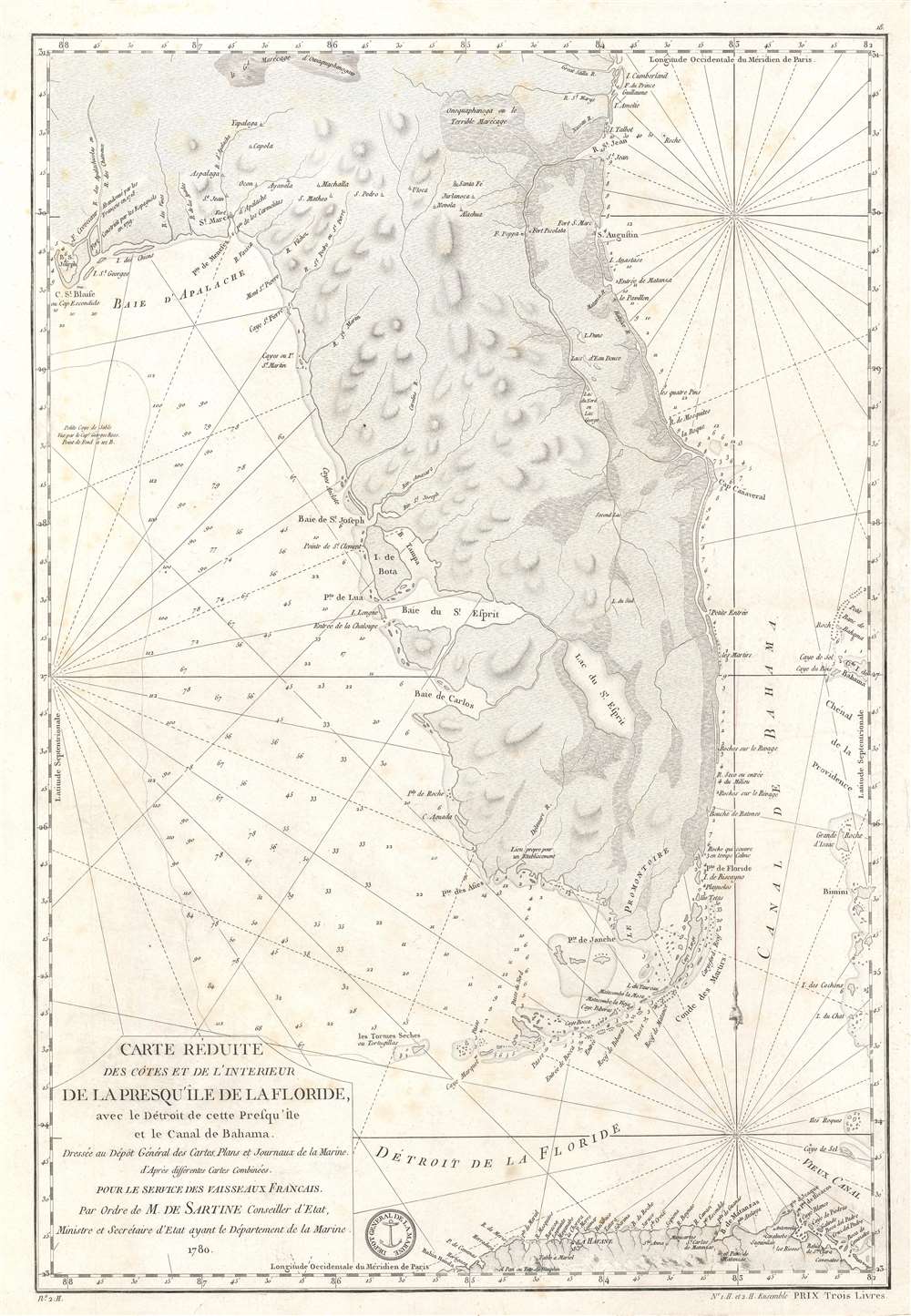
Carte Réduite des Côtes et de l'Interieur de la Presqu'île de la Floride, avec le Détroit de cette Presqu'Île et le Canal de Bahama.
1780 (dated) 24 x 16.5 in (60.96 x 41.91 cm) 1 : 1600000
1780 (dated) 24 x 16.5 in (60.96 x 41.91 cm) 1 : 1600000
Description
This is a 1780 Antoine de Sartine nautical map of Florida, issued for French Naval use during the American Revolutionary War.
A Closer Look
Coverage embraces from Apalachee Bay to the Atlantic Ocean and from Cumberland Island to Havana, Cuba. This chart was issued for use by the French Navy during the American Revolutionary War (1775 - 1783). Depth soundings are indicated along the Atlantic coast and a decent distance from the Gulf coast of Florida. Cays, bays, capes, and rivers are labeled, including the St. John's River, Tampa Bay, Cape Canaveral, and St. Joseph's Bay. Two notations north of Apalachee Bay comment on a fort that was built by the Spanish in 1719, and Fort Crevecoeur, which was apparently abandoned by the French in 1718.Florida During the Revolutionary War
During the American Revolutionary War, Florida, divided into East and West Florida, remained loyal to the British Crown, serving as a stronghold for Loyalists and a base for British military operations in the southern colonies. Spain, allied with the American revolutionaries, sought to regain control of Florida, which it had ceded to Britain in 1763. Spanish forces successfully captured West Florida in 1781, and the Treaty of Paris in 1783 returned both East and West Florida to Spanish control, ending British rule in the region.Publication History
This map was created by Antoine de Sartine and published by the French Dépôt des Cartes et Plans de la Marine in 1780.CartographerS
Antoine de Sartine (July 12, 1729 - September 7, 1801) was a competent, ruthless, and extravagant figure who dominated Paris for nearly 15 years. Formally Antoine Raymond Jean Gualbert Gabriel de Sartine, comte d'Alby, Sartine was born in Barcelona, Spain, the son of French financier Antoine Sartine. Upon the death of his mother, young Antoine was sent to Paris to be educated in Law. Following his studies, Sartine purchased the commission of Criminal Lieutenant of Police and was subsequently ennobled. A favorite of the King, he was soon appointed Lieutenant General of Police in 1759. This effectively made him dominant local power in Paris. Despite his purchased commission, Sartine proved to be a competent and effective city administrator. Paris flourished under his care, he restored public buildings, founded schools, improved finances, and tempered police corruption. He was also head of the French Intelligence organization, at the time the envy of Europe, and reported daily to the King with all of the city's gossip and scandals. This earned him the 1775 commission of Secretary of State for the Navy and the honorific rank of Minister of State. Sartine proceeded to expand and advance the French navy in competition with England. His influence put the French in a position to aid the American Revolutionaries against the British at the close of the Revolutionary War. It was during his tenure as head of the French Navy that Sartine ordered the creation of numerous updated nautical charts. Sartine's expansion of the Navy was reconsidered and deplored for its depletion of the French national treasury. As a result he was dismissed with honors in 1780. Following his dismissal, M. Sartine remained in Paris until the outbreak of the French Revolution. Unpopular with the French citizenry for his work as Police Lieutenant, he wisely fled to his childhood home of Barcelona, Spain. This no doubt saved his life as his son, who chose to stay behind, was shortly thereafter arrested and condemned to execution. Antoine de Sartine died in Tarragona, Spain in 1801. More by this mapmaker...
Dépôt des Cartes et Plans de la Marine (fl. 1720 - present), often called the Dépôt de Marine, was a French hydrographic mapping organization founded in 1720 under Charles-Hercule of Albert de Luynes (1674 - 1734). Much like the U.S. Coast Survey, the British Admiralty, and the Spanish Deposito Hydrografico, the Dépôt was initiated as a storehouse and distribution center of existing nautical and marine charts. Eventually the Dépôt initiated its own mapping activities in an attempt to improve and expand upon existing material. Some of the more prominent cartographers and hydrographers associated with the of Dépôt des Cartes were, Philippe Buache, Jacques-Nicholas Bellin, Giovanni Rizzi-Zannoni, Rigobert Bonne, and Jean Nicolas Buache. Learn More...
Condition
Very good. Even overall toning.
References
Touchton Map Library L2011.070.043. LOC G3930 1780 .F7. OCLC 973333698.