This item has been sold, but you can get on the Waitlist to be notified if another example becomes available, or purchase a digital scan.
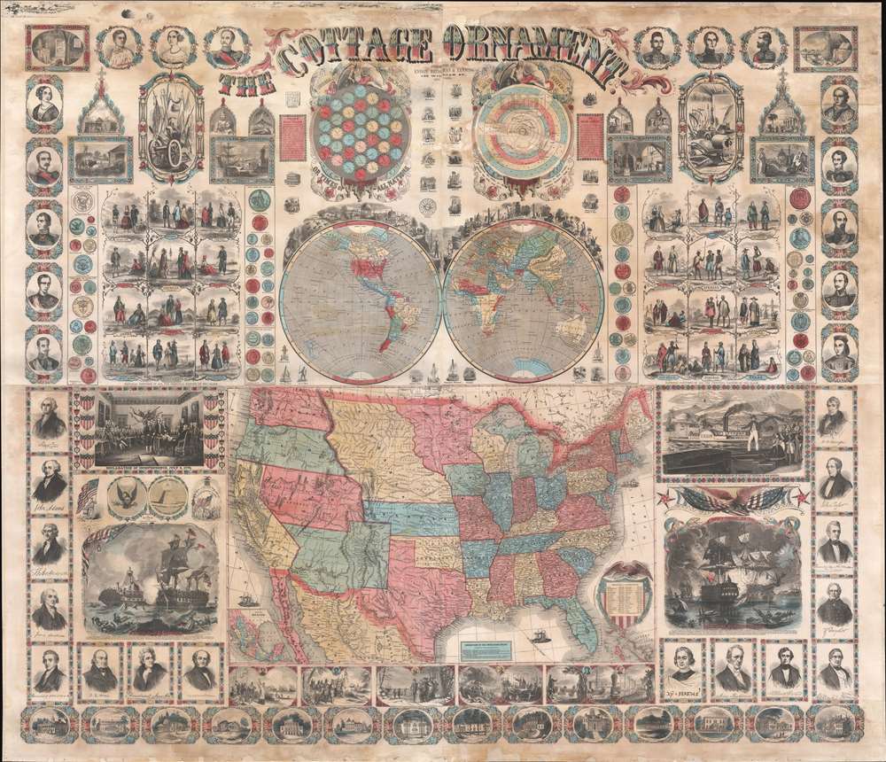
1857 Ensign, Bridgman, Fanning 'Cottage Ornament' Wall Map of the United States
CottageOrnament-ensighbridgeman-1857$3,000.00


Title
The Cottage Ornament.
1857 (undated) 51 x 51 in (129.54 x 129.54 cm) 1 : 14256000
1857 (undated) 51 x 51 in (129.54 x 129.54 cm) 1 : 14256000
Description
An impressive pedagogical tool, this is Ensign, Bridgman and Fanning's 1857 wall map of the United States with a densely informative surround. The complex and dense wall map was designed to address pedagogical issues of the mid-19th century, when the westward expansion and homesteading led to increased rural populations without access to educational infrastructure. It is intended to be a textbook at-a-glance, able teach American history, science, and geography, as well as inspire patriotic optimism. The overall organization and pictorial richness mean the reader need not even be literate to absorb the map's messages.
The Map
A large map of the United States occupies roughly 1/4th of the sheet. It depicts the United States in the heady years of expansion between the Mexican-American War (1846 - 1848) and the American Civil War (1861 - 1865). Nebraska Territory reaches from Kansas to the Canadian border. Washington and Oregon stretch from the Pacific to the Rocky Mountains. Utah likewise reaches from Pyramid Lake to the Rockys. Kansas stretches westward into modern day Colorado, roughly reaching Pikes Peak and South Park. New Mexico Territory reaches from Texas to California and the Colorado River.Pedagogical Surround
In addition to cartographic content, the map features an expansive pedagogical surround incorporating illustrations of the Solar System, Time Zones, American Presidents (and their luxurious estates), national costumes, technological innovations (the compass, electricity, the guillotine, chain shot, and more), natural and architectural wonders, examples of U.S. and foreign coinage, world leaders, and so much more. American patriotism is part of the map's message, with illustrations of the flag and national shields omnipresent, and images celebrating American military, naval, diplomatic, and innovative victories. Other vignettes trace the course of American history and invention from the Arrival of Columbus to the advent of the railroad age. In The Social Life of Maps in America, 1750-1860, Martin Brückner describes it thus,The Cottage Ornament ceases to be a map in the conventional sense; instead of posing as a medium whose message is the distribution of cartographic information, it resembles an exhibition poster or a storyboard akin to the didactic charts used by eighteenth-century street criers hawking their wars or nineteenth-century educators teaching lessons by pointing at pictures.
Rural Audience
The map was promoted heavily, largely in publications like the Wisconsin Farmer and American Agriculturist, underscoring its target audience: rural homesteaders underserved by the traditional educational system. Some of the original promotional text for the map survives, I quote the Wisconsin Farmer and North-Western Cultivator, April 1859,This new, large, and splendid sheet, in map form, is not ready, and is certainly the most attractive chart ever offered to the public. … It is well calculated to ornament every home in city and country, and will be found especially attractive to the family circle of 'little ones,' who will find on it a vast amount of instruction and amusement, by a study of the various objects delineated. Far more is comprehended on this one sheet than was every before given up the same number of square inches … Every home in each town and country of every State in the Union, ought to be supplied at once.
Publication History and Census
This map was compiled and published by the sort-lived partnership of Ensign, Bridgman, and Fanning. The firm, in its multitude of integrations, had the novel approach of engraving visual elements separately, then compiling the plates as a single map - thus allowing individual elements to be reused modularly on various maps. Such is much in evidence here, and while there is certainly plenty of fresh engraving, it also presents an amalgam of imagery drawn from earlier maps associated with Ensign, Thayer, Bridgman, and Fanning. We are aware of only one edition, which is undated, but advertisements for the map appear as early as 1857. The map proved popular, but given its distribution to far-flung rural communities, and schoolroom use it has a very low survival rate. Nonetheless, we recognize examples in a handful of institutions, but the map remains rare on the market.CartographerS
Edward Hooker Ensign (August 18, 1818 - July 10, 1871) was an American map and print publisher based in New York during the middle part of the 19th century. Edward was born in West Hartland, Connecticut. Little is known of Ensign's training but he may have inherited his business from his father, Timothy Ensign (1795 - 1859), who was a map publisher active in New York. Ensign seems to have had a flair for partnerships and variously published with Humphrey Phelps (1799 - 1875), Horace Thayer, Thomas C. Fanning (1805 - 1873) and Erastus C. Bridgman (1817 - 1870), among others. His various imprints include 'Phelps and Ensign' (1841-1844), 'T. and E. H. Ensign' (1844-1848), 'Ensign and Thayer' (1849), 'Ensign, Thayer, and Company' (1850-1851), 'Horace Thayer and Company' (1852), and 'Ensign, Bridgman and Fanning' (1854-1863). It appears that father and son worked together for some time as well, publishing as either 'T. and E. H. Ensign' or 'Ensigns'. At least some of these companies maintained offices in both Buffalo and New York City. More by this mapmaker...
Erastus Clark Bridgman (October 31, 1817 - August 25, 1870) was a New York City based map publisher active in the middle of the 19th century. Bridgman was born in Westhampton, Massachusetts. He was in South Carolina in 1849, where his first child was born, but moved to New York City by 1850. Bridgman was in partnership with Edward H. Ensign (1818 - 1871) and Horace Thayer from 1850 - 1852, publishing under the imprint of 'Ensign, Thayer, and Co.' Later, from 1854 - 1863, the partnership changed to Edward H. Ensign, Thomas C. Fanning (1805 - 1873), and Bridgman, publishing as 'Ensign, Bridgman and Fanning.' After his death, the Bridgman firm was taken over by his son Edward Clark Bridgman (1849 - 19??). Learn More...
Thomas Colt Fanning (August 2, 1805 - November 21, 1873) was a New York based map publisher active in the middle part of the 19th century. Fanning was born in Norwich, Connecticut. As a young man he apprenticed at a drugstore in Rochester, New York. When he reached his maturity, he relocated to Albion, New York, where he opened the town's first drugstore. He sold this business in 1849 to move to Brooklyn and enter the map publishing business. He initially partnered with Humphrey Phelps (1799 - 1875) and Thomas C. Fanning (1805 - 1873), joining the firm of 'Phelps and Fanning' as a junior partner. From 1854 to 1863 he partnered with Edward H. Ensign (1818 - 1871) and Erastus Clark Bridgman (1817 - 1870), publishing as 'Ensign, Bridgman and Fanning.' Learn More...
Condition
Good. Some staining and infill. Full professional restoration.
References
Rumsey 5477.000. Brückner, Martin, THe Social Life of Maps, page 228. OCLC 557781459.