This item has been sold, but you can get on the Waitlist to be notified if another example becomes available, or purchase a digital scan.
1900 St. Louis Southwestern Railroad Map of the Cotton Belt Route (TEXAS)
CottonBeltRoute-ssw-1900$325.00

Title
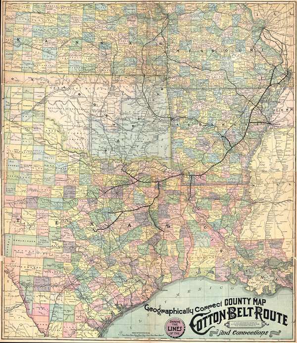
Geographically Correct County Map Showing the Lines of the Cotton Belt Route: St. Louis Southwestern Railway Co., St. Louis Southwestern Railway Co. of Texas, Tyler Southeaster Railway Co., and Connections.
1900 (undated) 34.5 x 30 in (87.63 x 76.2 cm) 1 : 1600000
1900 (undated) 34.5 x 30 in (87.63 x 76.2 cm) 1 : 1600000
Description
This is a c. 1900 St. Louis Southwestern Railway map of what was known as the 'Cotton Belt Route' in the southern United States. The map depicts the central portion of the southern United States including Kansas, Missouri, and southwestern Illinois, Texas, Louisiana, Kansas, Oklahoma, Tennessee, Mississippi, and of Arkansas. The Cotton Belt Route is a former class I railroad operating between St. Louis, Missouri and various cities in Texas, including Fort Worth, Sherman, and Waco. The rail line was active between 1891 and 1992, when the line was decommissioned.
Kansas, Missouri, Arkansas, Louisiana, and Texas are divided into counties, which are shaded different colors for easy identification. Oklahoma is separated in two: the western portion is labeled as Oklahoma, and the eastern portion is labeled as Indian Territory. Illinois, Tennessee, and Mississippi are not depicted in full and are not divided into counties. The map is highly detailed, with myriad cities, towns, and villages labeled. Streams, creeks, and rivers are also illustrated. Oklahoma is divided into the territory controlled by various Native American tribes.
This map was produced by the St. Louis Southwestern Railway Company c. 1900.
Condition
Very good. Backed on archival tissue for stability. Text on verso.