This item has been sold, but you can get on the Waitlist to be notified if another example becomes available, or purchase a digital scan.
1939 Fisher Map of the Border Lakes (Namaka Lake, Crane Lake) Minnesota
CraneNamakan-fisher-1939$75.00

Title
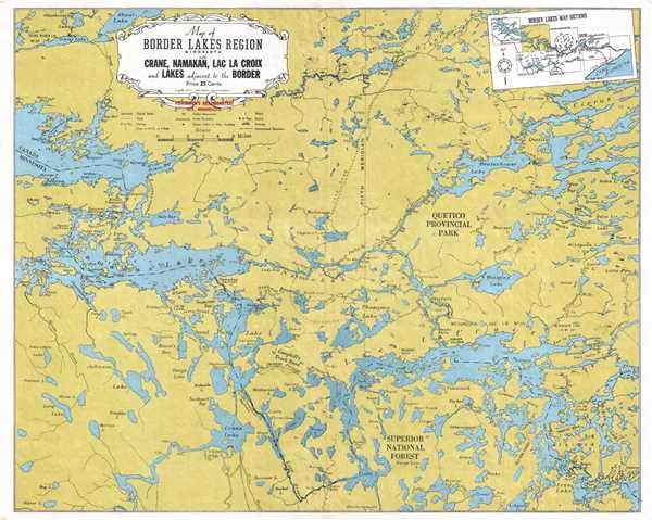
Map of Border Lakes Region Minnesota with Crane, Namakan, Lac La Croix, and Lakes Adjacent to the Border.
1939 (dated) 16 x 20 in (40.64 x 50.8 cm) 1 : 133000
1939 (dated) 16 x 20 in (40.64 x 50.8 cm) 1 : 133000
Description
This is a 1939 W. A. Fisher Company map of the border lakes region of Minnesota of the vicinity around Namaka Lake, Crane Lake, and Lac la Croix. The map depicts from the eastern end of Rainy Lake Rebecca Falls and Curtain Falls and from Shoal Lake to Oyster Lake, Lake Agnes and Iron Lake. Rainy Lake, Namakan Lake, and Lac la Croix are illustrated in detail, with bays, islands, and narrows labeled within each of the lakes. Smaller lakes appear all over the map, most of which are labeled. Swamps are also noted throughout, along with rapids and portages. County Road 42 is labeled, and other gravel roads and trails are illustrated. Surperior National Forest and Quetico Provincial Park are both depicted. A legend containing the different notations utilized on the map appears below the title cartouche and a diagram of the border lakes map sections is located in the upper right corner.
This map was published by the W. A. Fisher Company in 1939, and appears to have been distributed (more likely sold) at Fisherman's Headquarters in Ely, Minnesota.
This map was published by the W. A. Fisher Company in 1939, and appears to have been distributed (more likely sold) at Fisherman's Headquarters in Ely, Minnesota.
Condition
Very good. Blank on verso.