This item has been sold, but you can get on the Waitlist to be notified if another example becomes available, or purchase a digital scan.
1652 Caspar Merian Map of Crete
Crete-merian-1652$850.00

Title
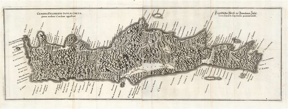
Genuina delineatio insulæ Cretæ, quam moderni Candiam appelant.
1652 (undated) 9 x 27 in (22.86 x 68.58 cm) 1 : 400000
1652 (undated) 9 x 27 in (22.86 x 68.58 cm) 1 : 400000
Description
This is a beautiful example of Caspar Merian's 1652 map of Crete. Of the 16th century maps of Crete, it is among the scarcest and most visually striking.
Source Cartography
Its overall outline hews to the 1612 Francesco Basilicata (???? - c. 1640) model. Basilicata, a military engineer, was sent to Crete in 1609 on behalf of the Venetian Republic to map the colony. His work, compiled in stages between 1609 and 1630, served as the dominant outline of Crete for the remainder of the 17th century. His manuscript represents the results of the last European survey before the Ottoman occupation. The manuscript was subsequently copied and printed in 1651 by Marco Boschini, whose work Merian followed in 1652.Updates and Improvements
Merian, as did Boschini, fills the map with pictorially-represented mountains in a unique visually impactful style. Coastal toponomy has been edited - removing smaller locations for the sake of legibility - with inland features more clearly presented. Towns and lakes are better differentiated than on the Boschini.Political Context
Merian's map was completed during the Cretan War, or the Fifth Ottoman-Venetian War (1645 - 1669). Early on, the Ottoman Empire absorbed most of Crete, but the fortress of Candia held out for 22 years before the final conquest. Thus, the present map focused not on ancient geography (a feature of most maps of Crete of the 16th and early 17th century) but on the contemporaneous situation. It was not until the 18th century that a significant update appeared.Publication History and Census
This map was engraved for inclusion in Merian's 1652 Theatrum Europaeum, and remained without change in subsequent editions of that work. We see only six examples of the separate map in institutional collections. It is rare on the market, with but a single example in catalog records.Cartographer
Caspar Merian (1627 - 1686) was a Swiss-German engraver and publisher, son of Matthäus Merian (1593 - 1650), who along with his brother Matthäus the younger (1621 - 1687) were active producers of maps and views in the 17th century, based in Frankfurt. Primarily the brothers would maintain and add to their father's existing works, the Topographia and Theatrum Europeaum, under the designation Merian Erben (Merian Heirs). More by this mapmaker...
Source
Merian, C. and M. II, Theatri Europaei, (Frankfurt) 1652.
Condition
Excellent. Very faint toning at join of sheets; visible folds. Else fine with a bold strike and generous margins.
References
OCLC 60536945. Zacharakis, C. G., A Catalogue of Printed Maps of Greece 1477-1800 #2288.