This item has been sold, but you can get on the Waitlist to be notified if another example becomes available, or purchase a digital scan.
1775 Jefferys Map of Cuba and the Florida Keys
Cuba-jefferys-1775$1,000.00

Title
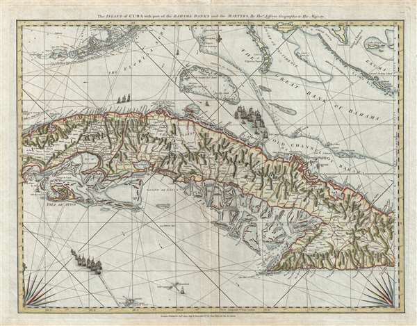
The Island of Cuba with part of the Bahama Bank and the Martyrs.
1775 (undated) 19.5 x 25 in (49.53 x 63.5 cm) 1 : 1430000
1775 (undated) 19.5 x 25 in (49.53 x 63.5 cm) 1 : 1430000
Description
A rare and important 1775 Thomas Jeffreys and Robert Sayer sea chart or nautical map of Cuba, the Florida Keys, and the Grand Bahama Bank. The map's coverage extends from just west of Havana down to the Sierra Maestra, the Cayman Islands (in the lower left), most of the Florida Keys (in the upper left), and the southern part of the Bahamas, including Nassau (upper right). It includes while the vital shipping passage of the Strait of Florida in the upper left quadrant.
Most Authoritative Map of the Region During Piracy Resurgence
This was the finest nautical chart of this region to yet appear, and a particular improvement over Jeffreys's own early chart of the region, the 1762, Map of the isle of Cuba, with the Bahama Islands, Gulf of Florida, and Windward Passage. It remained the most authoritative map of the region throughout the American Revolution until well after the Napoleonic Wars (1803 – 1815). When this chart was most used, from 1775 – 1825 (or so), there was a dramatic resurgence of privateering and piracy in and around the Greater Antilles. During the Seven Years War (1756 - 1763) and the Napoleonic Wars, Spain, England, and the United States all issued Letters of Marque, allowing privateers flying under their nation's flag to seize ships and trade goods flying the flags of enemy nations. This created a huge industry, not only at sea, but on land where confiscated goods were traded. This system crashed to a halt at the end of the Napoleonic Wars when most nations stopped issuing Letters of Marque. Privateers became Pirates until finally brought under control by American naval forces in 1825. This excellent map would have been used by all parties, including pirates, navy ships, and merchantmen.
Mapping the British Takeover of Havana.
The general improvements are derived from the events of the Anglo-Spanish War (1762 - 1763), part of the Seven Years War, wherein England's West India fleet occupied Havana from 1762 to 1764. During the occupation period, the British not only had access to earlier Spanish maps and hydrographic surveys, but also produced their own high-quality surveys of Cuba and the surrounding waters.
An Important British Mapping of the Florida Keys
The cartographer's treatment of the Florida Keys is also significant. At the end the Seven Years War, Cuba was one of the last remaining and most valuable Spanish properties in America, although in 1763 under British occupation. The 1763 Treaty of Paris, which ended the Seven Years' War, ceded Spanish Florida to Britain is exchange for Britain relinquishing all claims to Cuba. This led to several new and excellent surveys of south Florida and the Florida Keys conducted from 1765 to 1771 by William Gerard de Brahm, the Surveyor General of British East Florida. The mapping of the nearby Bahama Banks is based on British naval surveys.
Spanish Treasure Fleet and Shipwreck of the Santiago El Grande
The map illustrates the course of Spanish Treasure Fleet and the fleet itself pictorially. The Treasure Fleet was a naval convoy system which transported wealth and good from Cartagena, Colombia, to Havana, Cuba, to Sevilla, Spain, and vice versa. The system is legendary for the wealth it transported as well as the famous shipwrecks and disasters that it suffered.
The site of one of these wrecks is here identified, near Orange Cay, Bimini, in the Bahamas due east of Miami, Florida. This can only be the Santiago El Grande, which was sunk by a hurricane in 1765, as stated on his map. Supposedly it was transporting one of the largest hauls of gold and silver to have ever wrecked and has ever since been the target of hungry treasure hunters. In 1994, a Canadian treasure hunter claimed to have discovered the wreck, but his 'discovery' was never verified and many claim it to have been be an investment scam. To this day the Santiago El Grande has yet to be definitively discovered and some scholars consider it a 'ghost wreck.'
This map was drawn and engraved by Thomas Jeffreys and published posthumously by Robert Sayer in 1775 as part of Jeffreys's American Atlas. Although this map is a standalone chart, it could, theoretically, be combined with other 16 maps from the American Atlas into a gigantic nautical wall map of the West Indies. We have never seen nor heard of it displayed thus. This map is very rare on the market.
CartographerS
Thomas Jefferys (1695 - November 20, 1771) was one of the most prominent and prolific map publishers and engravers of his day. Jefferys was born in Birmingham and was apprenticed to the engraver Emmanuel Bowen in 1735. Later, in the 1740s he engraved several maps for the popular periodical Gentleman's Magazine. Around 1740 Jefferys was finally able to go into business for himself and in 1746 received an appointment as 'Geographer to Fredrick, Prince of Wales,' which shortly after translated to the position of 'Royal Cartographer to King George III.' Jefferys initially specialized in compiling and re-engraving the works of earlier cartographers into more coherent cartographic wholes. Later, while not salaried position, Jefferys' appointment as 'Royal Cartographer' guaranteed preferential access to the most up to date cartographic material available, allowing him to produce new and updated charts of exceptional accuracy. He his best known for his maps of the Americas, particularly the posthumously published 1775 American Atlas, which included some of the finest and most important late colonial era maps of America ever made. Despite his prolific publishing history, royal appointments, and international publishing fame, Jefferys lived most of his life in dire economic straits. He was bailed out of bankruptcy by Robert Sayer during the production of the American Atlas. In the end, Jefferys died suddenly with very little to his name. Nonetheless, his cartographic legacy survived, and even after his death in 1771, many of his important maps continued to be published and republished by Sayer and Bennet, Conrad Lotter, Georges Louis Le Rouge, Laurie and Whittle, and others. Many attribute some of Jefferys best maps to the colorful and criminally inclined Irish cartographic genius Braddock Mead (John Green, c. 1688 - 1757), who is considered the 'secret behind Jefferys.' Jefferys was succeeded by his son, also Thomas, who had little success as a cartographer and eventually partnered with, then sold his stock and plates to William Faden - Jefferys' true heir. More by this mapmaker...
Robert Sayer (1725 - January 29, 1794) was an important English map publisher and engraver active from the mid to late 18th century. Sayer was born in Sunderland, England, in 1725. He may have clerked as a young man with the Bank of England, but this is unclear. His brother, James Sayer, married Mary Overton, daughter-in-law of John Overton and widow of Philip Overton. Sayer initially worked under Mary Overton, but by December of 1748 was managing the Overton enterprise and gradually took it over, transitioning the plates to his own name. When Thomas Jefferys went bankrupt in 1766, Sayer offered financial assistance to help him stay in business and, in this way, acquired rights to many of the important Jefferys map plates as well as his unpublished research. From about 1774, he began publishing with his apprentice, John Bennett (fl. 1770 - 1784), as Sayer and Bennett, but the partnership was not formalized until 1777. Bennett retired in 1784 following a mental collapse and the imprint reverted to Robert Sayer. From 1790, Sayer added Robert Laurie and James Whittle to his enterprise, renaming the firm Robert Sayer and Company. Ultimately, Laurie and Whittle partnered to take over his firm. Sayer retired to Bath, where, after a long illness, he died. During most of his career, Sayer was based at 53 Fleet Street, London. His work is particularly significant for its publication of many British maps relating to the American Revolutionary War. Unlike many map makers of his generation, Sayer was a good businessman and left a personal fortune and great estate to his son, James Sayer, who never worked in the publishing business. Learn More...
Condition
Very good. Minor wear and margin verso reinforcement along original centerfold. Else clean. Blank on verso.
References
OCLC 855047197. Cueto, E., Cuba in Old Maps, no. 50. Sellers, J. and Van Ee, P., Maps and Charts of North America and the West Indies, no. 1784.