This item has been sold, but you can get on the Waitlist to be notified if another example becomes available, or purchase a digital scan.
1857 Chase Wall Map of Cumberland County, Maine (Portland, Casco Bay)
CumberlandMaine-chase-1857$1,750.00


Title
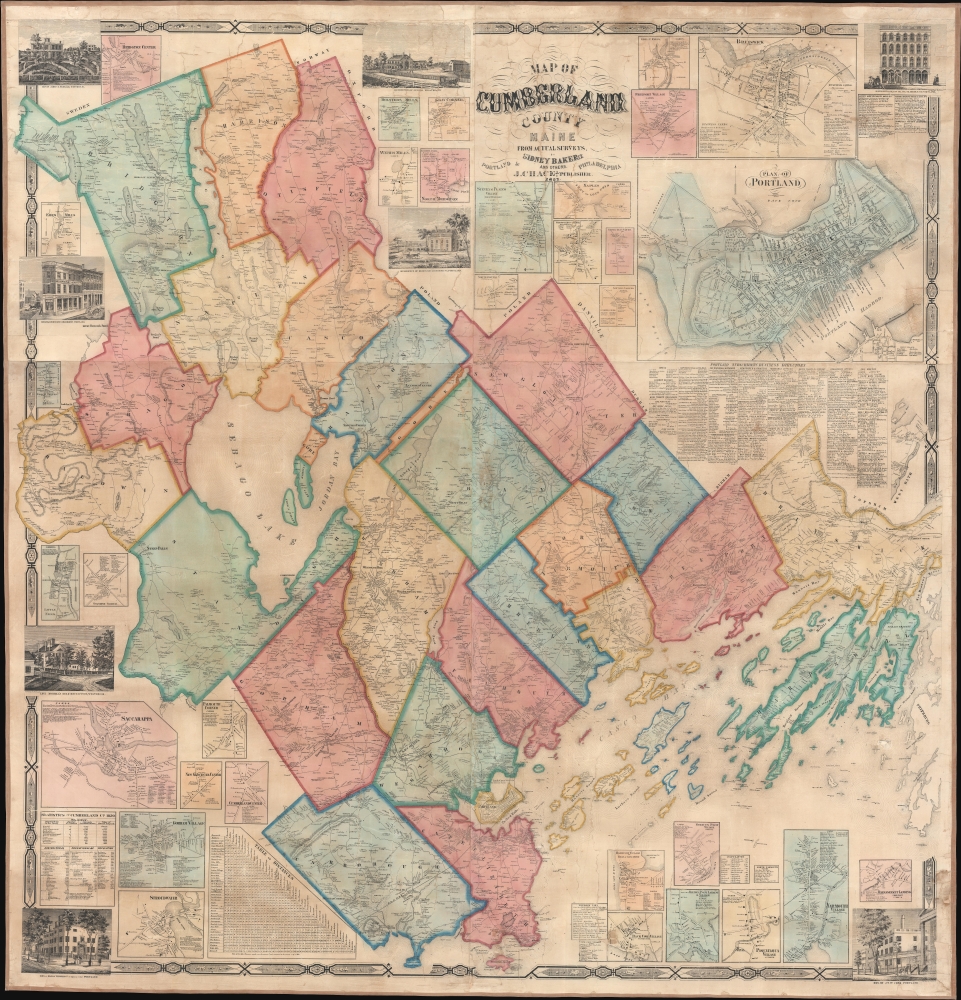
Map of Cumberland County Maine from actual surveys.
1857 (dated) 58 x 60 in (147.32 x 152.4 cm) 1 : 51600
1857 (dated) 58 x 60 in (147.32 x 152.4 cm) 1 : 51600
Description
An attractive 1857 wall map of Cumberland County, Maine, including Portland and Casco Bay.
A Closer Look
The map extends from Bridgton to Casco Bay and from Keazer Pond to Brunswick, with details including individual property owners. Thirty-two inset maps surround the central map of Cumberland County, detailing towns and villages. The most prominent inset, situated in the upper right, details Portland. A list of 'Portland Subscribers' and a local business directory are included below the plan. All the inset maps label private residences, shops, and schools. Eight pictorial vignettes also appear and focus on local businesses that probably paid for the privilege of being so represented, along with a few noteworthy personal estates.Historical Context
In the mid-19th century, Cumberland County, Maine, was characterized by a burgeoning agricultural economy, thriving maritime industry, and growing urban centers. Situated in Maine's Mid-Coast, the county encompassed a diverse landscape of fertile farmland, excellent ports, and inland villages. The county seat, Portland, exploded in size and population as a bustling hub of commerce and culture, serving as a vital center for shipping and trade. Surrounding towns such as Brunswick and Westbrook grew into shipbuilding and industrial centers. Despite occasional challenges such as economic fluctuations and political tensions, Cumberland County epitomized the spirit of progress and opportunity characteristic of the burgeoning American nation in the mid-19th century.Publication History and Census
This map is based upon original surveys conducted by the civil engineer Sidney Baker. It was published in a single edition by Josiah Chace Jr. We note 5 examples cataloged in OCLC: Osher Map Library at the University of Southern Maine, the Maine State Library, the University of Maine at Orono, the Library of Congress, and the Wisconsin Historical Society.Cartographer
Josiah G. Chase (December 6, 1819 - July 17, 1903) was an American civil engineer and mapmaker. Born in Atkinson, Maine, Chase was a civil engineer and surveyor who lived in Cambridge, Massachusetts for most of his professional life. He married Susan E. Chase (her maiden name is not known) (c. 1824 - c. 1902) in 1851. Chase published several maps, including a railroad map of Boston and a map of the street rail routes in suburban Boston. More by this mapmaker...
Condition
Very good. Professionally restored and stabilized with fresh linen backing.
References
OCLC 807284155, 822962913.