This item has been sold, but you can get on the Waitlist to be notified if another example becomes available, or purchase a digital scan.
1700 Gerard Valk Map of the Dauphiné Region, France
Dauphane-valk-1700$187.50

Title
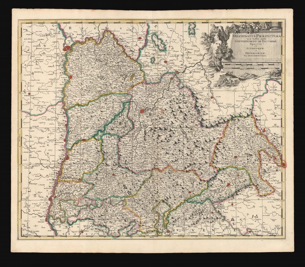
Delphinatus Praefectura quae Gallis audit Gouvernement de Dauphine.
1700 (undated) 19.25 x 23.25 in (48.895 x 59.055 cm) 1 : 460000
1700 (undated) 19.25 x 23.25 in (48.895 x 59.055 cm) 1 : 460000
Description
This is a beautiful c. 1700 map of the Dauphiné region of France, by Dutch cartographer Gerard Valk.
The Dauphiné, known as the playground of Europe's elite, is admired for its stunning natural beauty, distinctive culture, superb cuisine, delightful beaches, and fantastic wines. Isere is known for its production of Bleu du Vercors-Sassenage, a mild cow's milk blue cheese, and Saint-Marcellin, a softer cheese, while Drome is famous for its production of Picodon, a spicy goats-milk cheese. The Hautes Alpes area of France is known for its production of Coteaux and Collines Rhodaniennes wines, and is also famous for its chestnuts.
This area also houses a number of vineyards. Here you will find the AOC Coteaux varois en Provence, which produces a wide variety of reds and whites. The red wines principally use the grenache, cinsaut, mourvedre and syrah grapes. White wines use the clairette, grenache blanc, rolle blanc, Semillon Blanc, and Ugni Blanc.
A Closer Look
It details part of the Rhone-Alpes and Provence-Alpes-Cote d’Azure regions and the departments of Drome, Isere, and Hautes-Alpes, including the cities of Grenoble, Lyon, and reaches as far east as Pignerol (Pinerolo). Here, that city is French territory, at the extreme of the Balliage de Briancon.This part of the Piedmont had been taken by the French during the Thirty Years' War (1618 - 1648). It was supposed to have been returned to Savoy in 1696, according to the Treaty of Turin although that change is not reflected here.A Beautiful Engraving
Although printed at the beginning of the 18th-century, this is engraved in the classic Dutch style of the late 17th-century. The title cartouche in the upper right is elegant, and styled as a garlanded plinth. In the background are mountains, evoking the region's alpine terrain.The Dauphiné, known as the playground of Europe's elite, is admired for its stunning natural beauty, distinctive culture, superb cuisine, delightful beaches, and fantastic wines. Isere is known for its production of Bleu du Vercors-Sassenage, a mild cow's milk blue cheese, and Saint-Marcellin, a softer cheese, while Drome is famous for its production of Picodon, a spicy goats-milk cheese. The Hautes Alpes area of France is known for its production of Coteaux and Collines Rhodaniennes wines, and is also famous for its chestnuts.
This area also houses a number of vineyards. Here you will find the AOC Coteaux varois en Provence, which produces a wide variety of reds and whites. The red wines principally use the grenache, cinsaut, mourvedre and syrah grapes. White wines use the clairette, grenache blanc, rolle blanc, Semillon Blanc, and Ugni Blanc.
Publication History and Census
This map was engraved by Gerard Valk for inclusion in his atlases. It is typically dated 1700 to 1710, corresponding with Valk's atlases, but it is not known when it was actually executed, and may have been as much as 20 years earlier, as Valk's maps were included in composite atlases throughout the latter seventeenth century.Cartographer
Gerard Valk (September 30, 1652 - October 21, 1726) (aka. Valck, Walck, Valcke), was a Dutch engraver, globe maker, and map publisher active in Amsterdam in the latter half of the 17th century and early 18th century. Valk was born in Amsterdam where his father, Leendert Gerritsz, was a silversmith. He studied mathematics, navigation, and cartography under Pieter Maasz Smit. Valk and moved to London in 1673, where he studied engraving under Abraham Blooteling (or Bloteling) (1634 - 1690), whose sister he married, and later worked for the map sellers Christopher Browne and David Loggan. Valke and Blooteling returned to Amsterdam in 1680 and applied for a 15-year privilege, a kind of early copyright, from the States General, which was granted in 1684. In 1687, he established his own firm in Amsterdam in partnership with Petrus (Pieter) Schenk, who had just married his sister, Agata. They published under the imprint of Valk and Schenk. Also, curiously in the same year Valk acquired the home of Jochem Bormeester, also engraver and son-in-law of art dealer Clement De Jonghe. Initially Valk and Schenk focused on maps and atlases, acquiring the map plates of Jodocus Hondius and Jan Jansson in 1694. Later, in 1701 they moved into the former Hendrick Hondius (the younger) offices where they began producing globes. Valk and Schenk soon acquired the reputation of producing the finest globes in the Netherlands, a business on which they held a near monopoly for nearly 50 years. In 1702, Valk joined the Bookseller's Guild of which he was promptly elected head. Around the same time, Gerard introduced his son, Leonard, who was married to Maria Schenk, to the business. Leonard spearheaded the acquisition of the map plates of Frederick de Wit in 1709. Nonetheless, Leonard was nowhere near as sophisticated a cartographer or businessman as his father and ultimately, through neglect, lost much the firm's prestige. After his death, the firm was taken over by his widow Maria. More by this mapmaker...
Source
Valk, G., Nova Totius Geographica Telluris Proiectio, (Amsterdam) 1700.
Condition
Excellent. Light marginal toning, else fine with original outline color.
References
OCLC 159800394.