This item has been sold, but you can get on the Waitlist to be notified if another example becomes available, or purchase a digital scan.
1884 Wellge / Stoner Bird's Eye View Map of De Land, Florida
DeLandFlorida-wellge-1884$1,500.00

Title
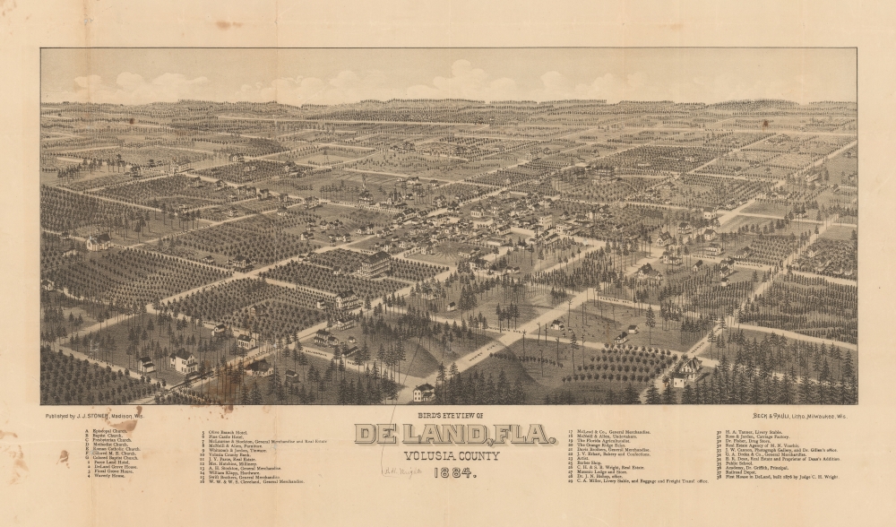
Bird's Eye View of De Land, Fla. Volusia County 1884.
1884 (dated) 13 x 22.5 in (33.02 x 57.15 cm)
1884 (dated) 13 x 22.5 in (33.02 x 57.15 cm)
Description
A very rare 1884 Stoner / Wellge bird's-eye view of DeLand Florida at the height of the first Florida Citrus Boom and the Second Florida Land Boom - which centered around DeLand.The view looks northeast on Deland. Thirty-eight business, offices, hotels, and civic buildings rea named, as well as seven churches. Orange grows are evident throughout, underscoring DeLand's significance as a center of the Citrus Boom.
City views were being produced in the United States as early as the 1830s, but the genre exploded after the American Civil War (1861 - 1865). Bridging the gap between maps and pictures, most 19th century American bird's-eye views presented cities to the public from high vantage points. Some were imagined, but others were drawn from hot-air balloons or nearby hills. The presentation, combining high elevation, commercial interest, and new printing technology, created a uniquely American art form, as described by historian Donald Karshan,
Manuscript Content: Berlin H. Wright
Manuscript content points to the home of B. H. Wright. This can only be Berlin Hart Wright (1851 - 1940). Wright was an astronomer, surveyor, and geologist. He was born in Dundee, New York. He taught briefly at Penn Yan Academy, before developing a deep interest in the Mound Builder cultures of the American mid-west. He studied and surveyed the ruins extensively. From in the 1880s, Wright began wintering in DeLand, Florida, where he built a home and contributed to the surveying and naming of Ponce de Leon springs. After his death, his descendants continued to live in and around DeLand.Second Florida Land Boom
In the second half of the 19th and throughout the early 20th century, Florida experienced a series of land booms and crashes. The first followed the Second Seminole War (1835 - 1842), when the government offered homesteaders who agreed to stay five years 160 acres of free land. The second - represented by the growth of DeLand - follows the arrival of the railroads to central Florida, leading to nearly 15 years of prosperity and economic growth - mostly revolving around the booming citrus industry. New settlements sprang up throughout the northern half of the state, many owned by absentee investors who never personally visited Florida. The boom collapsed in 1894-95 when a series of historical freezes wiped out the citrus harvest. Property depreciation following the freezes allowed Henry Flagler (1830 - 1913) to develop the Florida East Coast Railway. This, and the arrival of the highway system in the 1920s, led to the third Florida land boom from 1920 to the stock market crash of 1929.American Bird's-Eye City Views
The tradition of the bird's-eye city view emerged in the United States in the middle part of the 19th century and coincided with the commercial development of lithographic printing. Before the rise of lithography, the ability to own and display artwork in the home was largely limited to the extremely wealthy, the advent of lithographic printing made it possible for everyone to own visually striking artwork. A robust trade developed in portraits of political leaders, allegorical and religious images, and city views.City views were being produced in the United States as early as the 1830s, but the genre exploded after the American Civil War (1861 - 1865). Bridging the gap between maps and pictures, most 19th century American bird's-eye views presented cities to the public from high vantage points. Some were imagined, but others were drawn from hot-air balloons or nearby hills. The presentation, combining high elevation, commercial interest, and new printing technology, created a uniquely American art form, as described by historian Donald Karshan,
Some print connoisseurs believe that it was only with the advent of the full-blown city-view lithograph that American printmaking reached its first plateau of originality, making a historical contribution to the graphic arts. They cite the differences between the European city-view prints and the expansive American version that reflects a new land and a new attitude toward the land.The vogue for bird's-eye city views lasted from about 1845 to 1920, during which period some 2,400 cities were thus portrayed, some multiple times. Although views were produced in many urban centers, the nexus of view production in the United States was Milwaukee, Wisconsin. The major American viewmakers were Stoner, Wellge, Bailey, Fowler, Hill, Ruger, Koch, Burleigh, Norris, and Morse, among others.
Publication History and Census
This view was published by J. J. Stoner of Madison, Wisconsin in 1888. It was engraved on stone by Henry Wellge and printed by Beck and Pauli, both of Milwaukee. We note examples in the Library of Congress and at the Touchton Map Library, Tampa.CartographerS
Henry Wellge (1850 – 1923) was an American panoramic bird's-eye view publisher, artist, and cartographer active in Milwaukee in the late 19th and early 20th century. Wellge was born in Germany in 1850. His first view, in 1878, was of Chilton Wisconsin, but most of his early work is in association with J. J. Stoner, another prolific view maker. Eventually established his own firm Henry Wellge and Company. Later his published and Norris, Wellge and Company. Ultimately though, most of his work appears under the imprint of the American Publishing Company. He continued to publish views until about 1910 with about 152 views bearing his imprint. Wellge is known for large dramatic views illustrated with emphasis on the horizontal dimension. More by this mapmaker...
Joseph John Stoner (December 21, 1829 - May 1917) was a Madison, Wisconsin based publisher of bird's-eye city views active in the late 19th and early 20th centuries. Stoner was born in Highspire, Pennsylvania and apprenticed as a carver of ornamental chairs before turning to publishing. He partnered with the bookseller Ephraim T. Kellogg of Madison, Wisconsin, for whom he was a traveling agent. His career in views began around 1867 when he met and befriended the bird's-eye view artist Albert Ruger, who was sketching Madison that year. Ruger and Stoner partnered and began publishing city views under the imprint 'Ruger & Stoner.' The partners traveled extensively through the Midwest publishing some 11 city views under their joint imprint - although there may be as many as 62 others unattributed. The partnership partially dissolved in 1872 although they continued to work together on a contractual basis. Stoner subsequently traveled even more extensively, hiring young artists to sketch city views in such wide ranging destinations as Texas, Maine, and Oregon, among others. He produced a total of some 314 views with various artists including: Albert Ruger, Herman Brosius, Thaddeus M. Fowler, Augustus Koch, Albert F. Poole, Henry Wellge, Joseph Warner, and Camille N. Drie (Dry). Stoner died in Berkeley, California in 1917. Learn More...
Beck and Pauli (fl. c. 1878 – 1889) was a Milwaukee, Wisconsin based lithography firm founded in 1878 by Clemens J. Pauli and Adam Beck. The firm published hundreds of lithograph city views for many of the most prominent viewmakers of the period, including Lucien Rinaldo Burleigh, J. J. Stoner, Henry Wellge, Pauli himself, and others. The company was most active in the mid-1880 until about 1889, when the partners went separate ways and closed the company. Learn More...
Condition
Good. Laid on archival tissue. Some wear and slight loss on old fold lines. Stains in lower left quadrant. Manuscript annotation.
References
Library of Congress, G3934.D5A3 1884 .W4. Touchton Map Library, M1405.