This item has been sold, but you can get on the Waitlist to be notified if another example becomes available.
1960 Directorate of Advertising Pictorial Tourist Map of Delhi, India
Delhi-advertising-1960$75.00


Title
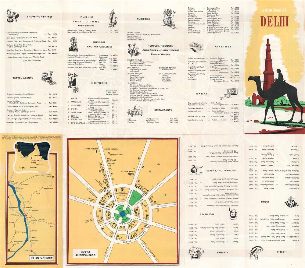
Guide Map of Delhi. Delhi The Capital City.
1960 (undated) 19.25 x 16 in (48.895 x 40.64 cm)
1960 (undated) 19.25 x 16 in (48.895 x 40.64 cm)
Description
This is a c. 1960 Directorate of Advertising and Visual Publicity pictorial tourist map of Delhi, India. Depicting the city inside the Ring Road, pictorial vignettes illustrate monuments and government buildings. Humayun's Tomb, the Lodi Tombs/Gardens, Qutb Minar (Qutub Minar), and Safdar Jang's Tomb appear, along with several others. Pictorial icons mark hotels, banks, cinemas, temples, mosques, and other locations around the city and a key situated in the lower left corner provides the viewer with this information. Neighborhoods throughout Delhi are identified, and major streets are labeled. Railroads to Jaipur, Rohtak, Ambala, Kolkata (Calcutta), and Agra are illustrated and labeled. A map of Connaught Place and of the region surrounding Delhi appear on the verso, along with a location index with telephone numbers.
Publication History and Census
This map was created by the Directorate of Advertising and Visual Publicity of the Ministry of Information and Broadcasting of the Government of India. It was issued by the Tourist Division of the Ministry of Transport and printed by Caxton Press in New Delhi. We note cataloged items bearing the same name in OCLC, but we have been unable to confirm if any of these OCLC entries represent the present map.Condition
Very good. Light wear along original fold lines. Location index and map of Connaught Place on verso.