This item has been sold, but you can get on the Waitlist to be notified if another example becomes available, or purchase a digital scan.
1586 Waghenaer Nautical Chart of Coast of Denmark and Sweden
DenemarkenenSwederyck-waghenaer-1586$1,000.00

Title
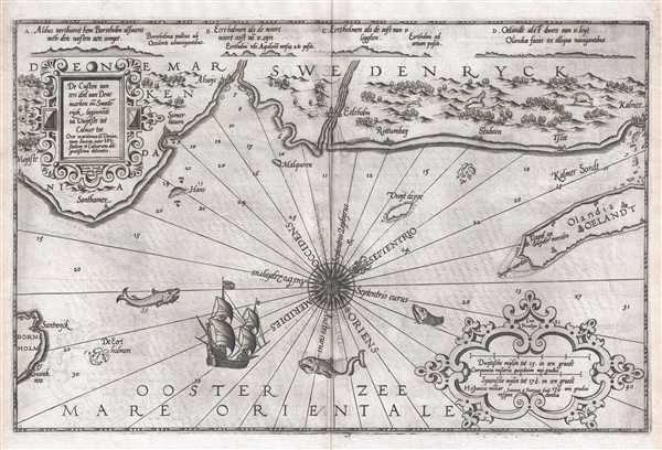
De Custen van een deel van Denemarken en Swederÿck, beginnede va Uuytste tot Calmer Toe…
1586 (undated) 21.25 x 14 in (53.975 x 35.56 cm) 1 : 390000
1586 (undated) 21.25 x 14 in (53.975 x 35.56 cm) 1 : 390000
Description
This 1586 nautical chart or maritime map of Sweden and Denmark along the North Sea was produced by Lucas Janszoon Waghenaer for his 1586 Spieghel Der Zeevaerdt, a chart book of European coastlines. This nautical chart is oriented to the northeast and covers the coast of modern day Sweden from Vuytste and Bornholm (Bornholm) to Kalmar (Kalmer) and Öland (Olandia/Oeland). This chart features an intricate compass rose in the center with eight compass headings labeled as well as two decorative cartouches, one for the chart title and one for the chart scale. Depth soundings are recorded throughout. Shallow water is noted by stippling and a safe harbor is depicted with an anchor at Somerhauen. Sea creatures and a sailing ship are included in the sea. The towns along the coast are depicted realistically so that they could be easily identified while at sea and forests and mountains are drawn in profile. Farm buildings and fields are represented and a boar, goat, and fox are included for gorgeous detailing.
Cartographer
Lucas Janszoon Waghenaer (c. 1533 - 1606) was a Dutch cartographer born in Enkhuizen. He was one of the founding members of the North Holland school of cartography, as well as one of its most famous proponents. The North Holland school played a major role in the early development of Dutch nautical chart-making. More by this mapmaker...
Source
Waghenaer, Lucas Janzoon, Spieghel Der Zeevaerdt
Spieghel Der Zeevaerdt was the first published nautical atlas and became an immediate success. Partially based on Waghenaer's observations as a navigation officer and partially on his vast experience in practical navigation methods, Spieghel Der Zeevaerdt combines text, which is based on traditional 16th century navigation publications, and charts which makes this the world's first published pilot guide. This atlas was printed in folio format, an innovation for the time, and was eventually printed in Dutch, French, English, German, and several other languages. Waghenaer eventually published several other editions of his pilot guides, which were smaller and more practical, particularly with mariners as the large folio editions were difficult to use onboard ship.
Condition
Very good. There is some slight transference.
References
OCLC 819296710