This item has been sold, but you can get on the Waitlist to be notified if another example becomes available, or purchase a digital scan.
1907 Clason Map of Denver, Colorado
Denver-clason-1907$187.50

Title
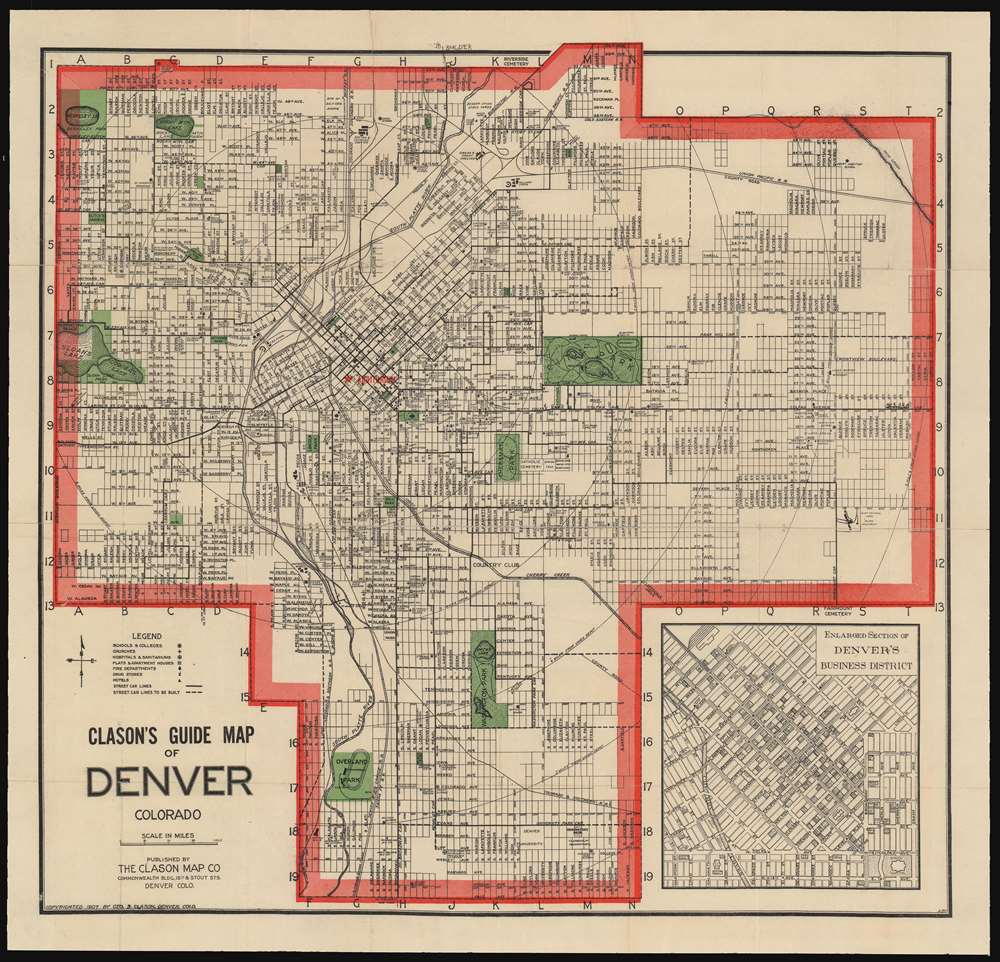
Clason's Guide Map of Denver Colorado.
1907 (dated) 19.25 x 20.25 in (48.895 x 51.435 cm) 1 : 31680
1907 (dated) 19.25 x 20.25 in (48.895 x 51.435 cm) 1 : 31680
Description
An attractive example of George Clason's 1907 guidebook and map of Denver, Colorado. This map covers the growing city from Berkley Lake to Yale Avenue and from Sloans Lake to Yosemite Street. Though the map has not expanded yet to include Aurora (as it would be in later editions) the municipality is marked in manuscript along Colfax Avenue between Ulster and Wabash streets. An inset in the lower right quadrant details the Denver Business District.
’No city in the United States of its size is as well and favorably known as Denver’
The map, in conjunction with the included Clason's 1907 Guide to Denver, was clearly intended to encourage resettlement to a vigorous, inviting city. The map shows the locations of important buildings - not only municipal structures and hospitals and fire stations and the like, but apartment buildings, hotels and even drug stores. The guide glosses quickly over city history, lingering instead on the topics of ‘Denver as a Business Center,’ ‘Denver as a Residence City’ and a description of the city’s ‘Parks.’ The map, too, emphasizes the park system: indeed, more than twenty are identified and highlighted in green.Publication History and Census
Clason’s guide maps appeared in multiple editions, and are found for the most part in 1920s issues. While there is little definitive data available, this is the earliest edition of this map that we have identified either in the trade or in library collections. It is the earliest to be listed in OCLC.Cartographer
George Samuel Clason (November 7, 1874 - 1957) was born in the city of Louisiana, Missouri in 1874. As a young man, Clason studied at the University of Nebraska before joining the United States Army in 1898 to fight in the Spanish American War. After the war, he moved to Denver, Colorado where in 1905 he founded the Clason Map Company, thus starting his lucrative publishing career. Clason initially focused on mining and mineral maps - capitalizing on the Colorado and Nevada mining industry, but quickly transitioned to railroad maps, city maps, and by the 1920s, road maps. As the company expanded, Clason opened a secondary office in Chicago, Illinois - then a rising map publishing center and railroad hub. At least one other satellite office was opened in Los Angeles. Among his many achievements, Clason is credited with producing the first modern road atlas of the United States. In the late 1920s, Clason also published a series of get-rich-quick pamphlets in the form of parables. The most famous of these is The Richest Man in Babylon. This tells the story of Arkad, a citizen of Babylon famed for his great wealth and generosity who shares his wit and wisdom with his fellow Babylonians. In 1949, Clason moved to Napa, California to retire and found a social club for retired gentlemen. More by this mapmaker...
Source
Classon, G., Clason's Guide to Denver with Map, (Denver: Clason Map Company) 1907.
Condition
Good condition. Map has been flattened and backed with archival tissue, few surface mends with minor loss. Comes with original guidebook.
References
OCLC 233971166.